WawonaNews.com - August 2012
Wawona Area Mechanical Thinning
Hazardous Fuels Reduction Project
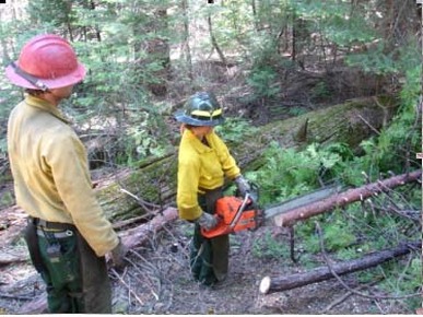
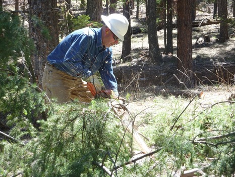
Yosemite Fire Crew 6 is working near Swinging Bridge conducting a hazardous fuel reduction project. They are cutting, piling and mechanically thinning dense vegetation including shade tolerant conifers such as incense cedar, white fir and ponderosa pine. They are also clearing accumulated dead biomass on the forest floor like sticks and logs. You will hear chain saws and see crews cutting trees and piling the brush for burning later in the year when conditions are cool and wet.
Additionally, fire crews are accumulating and will save 3’’ to 10” in diameter cedar stems and logs that will be recycled for historic structure restoration in the park.
This process of fuel reduction is one tool used by the National Park Service to reduce heavy accumulation of fuels, ultimately to prevent larger fires. In turn, this helps preserve natural and cultural resources, and provide for public and firefighter safety. These projects also serve to protect park and community structures and other cultural and natural values at risk from larger unwanted wildland fires in the Wildland Urban Interface areas (WUI).
The project also removes excess ‘ladder’ fuels that can carry fire from the forest floor to the canopy (tops of trees) in the event of an unwanted wildfire. When the project is completed, visitors will notice clearer, more open forest in these areas. This is more typical of what forests in the Sierra Nevada Mountains looked like under a natural, frequent, lightning caused fire regime. The dense forests are the result of fire suppression for over 100 years which increased the potential for catastrophic wildfire in the park.
The Wawona mechanical thinning project is one of four areas of thinning being conducted in the park. El Portal, Foresta and roadside thinning along Wawona Road are other area currently being treated.
Hikers and backpackers and users of the South Fork of the Merced River are welcome to observe the crews. For safety you are urged to stay on the path and do not enter into the forested thinning project area.
For additional Information
Fire Information and Education: [email protected]; (209) 375-9574 or (209) 372-0480.
· Yosemite Fire Management Website: http://www.nps.gov/yose/parkmgmt/current_fire.htm.
Wawona Mechanical Thinning
Yosemite Fire Crew 6 is working near Swinging Bridge conducting a hazardous fuel reduction project. They are cutting, piling and mechanically thinning dense vegetation including shade tolerant conifers such as incense cedar, white fir and ponderosa pine. They are also clearing accumulated dead biomass on the forest floor like sticks and logs. You will hear chain saws and see crews cutting trees and piling the brush for burning later in the year when conditions are cool and wet. Additionally, fire crews are accumulating and will save 3’’ to 10” in diameter cedar stems and logs that will be recycled for historic structure restoration in the park. This process of fuel reduction is one tool used by the National Park Service to reduce heavy accumulation of fuels, ultimately to prevent larger fires. In turn, this helps preserve natural and cultural resources, and provide for public and firefighter safety. These projects also serve to protect park and community structures and other cultural and natural values at risk from larger unwanted wildland fires in the Wildland Urban Interface areas (WUI).
The project also removes excess ‘ladder’ fuels that can carry fire from the forest floor to the canopy (tops of trees) in the event of an unwanted wildfire. When the project is completed, visitors will notice clearer, more open forest in these areas. This is more typical of what forests in the Sierra Nevada Mountains looked like under a natural, frequent, lightning caused fire regime. The dense forests are the result of fire suppression for over 100 years which increased the potential for catastrophic wildfire in the park. The Wawona mechanical thinning project is one of four areas of thinning being conducted in the park. El Portal, Foresta and roadside thinning along Wawona Road are other area currently being treated.
Hikers and backpackers and users of the South Fork of the Merced River are welcome to observe the crews. For safety you are urged to stay on the path and do not enter into the forested thinning project area.
For additional Information
Fire Information and Education: [email protected]; (209) 375-9574 or (209) 372-0480.
Yosemite Fire Management Website: http://www.nps.gov/yose/parkmgmt/current_fire.htm. (G. Wuchner)
__________________________
Taft Toe Prescribed Fire
This prescribed fire has been postponed. A later date will be announced.
For additional Information
Fire Information and Education: [email protected]; (209) 375-9574 or (209) 372-0480. (G. Wuchner)
__________________________
Yosemite Fire - Update #2 – July 26, 2012
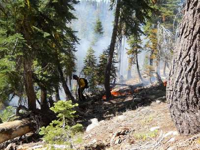
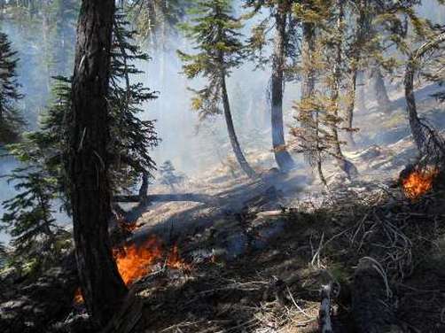
Cascade: (37 46.173 x 119 40.519; 7800’el. Mariposa Co.) This lightning caused fire has been slowly burning since June 16, in Yosemite’s high elevation Wilderness. It started during an afternoon thunderstorm on June 15th. The fire has grown to 109 acres. It is burning in a short needle red fir forest between two upper forks of the Cascade Creek. The fire has slowly smoldered through sparse surface fuels of duff, forest litter and occasionally creating enough heat to ignite brush. The southern perimeter edge is the most active with occasional 6 to 12 inch flame lengths during the hottest part of the day. Currently, the fire poses no threat to trails, park service buildings, infrastructure or roads, cultural or natural resources.
The fire could potentially grow to 1000 acres over the next month due to typical warm and dry weather for this time of year. Firefighters continue to monitor and scout the fire to determine the potential in growth and spread direction. Although the immediate fire area has a history of lightning, there is no recorded recent large fire history. Normally fuels too wet during this time of year to support active fire growth. Due to light winter snowpack this year, fuels at this elevation are now able to support fire spread and allow this natural fire to play a vital role in Yosemite Wilderness. The nearest historic fire to the Cascade Fire suggest that fires at this elevation, in this forest type, creep and smolder for weeks and only make runs during dry windy conditions.
Red fir forests burn about every 30 years. Cascade Fire is burning in an area that has not burned in at least 60-90 years. Because there are no resources threatened at this time or in the near term future, allowing this fire to burn in this area, this year promotes healthy, resilient ecosystem function. If resources are threatened, and/or smoke impacts threaten human health, fire managers will reassess the objectives of this fire.
Though California is hot and dry, which is typical for this time of year and there are few fires burning in our region. Other fires nationally are starting to wind down due to cooler weather and monsoonal flow patterns assisting firefighters in suppression efforts. Resources are available to assist with managing the Cascade Fire. The Cascade Fire meets the park fire management objectives of minimal risk to firefighter and public safety, federal and public property, air quality and Wilderness character.
Light smoke has been visible mainly in the morning hours near Cascade Falls and the community of Foresta. Smoke may become more visible at high locations within the park. Fire managers are working closely with state and local air pollution regulators concerning potential adverse air quality impacts to nearby smoke sensitive areas. Yosemite’s Division of Resources Management and Sciences personnel have installed air quality monitoring equipment within the communities of Lee Vining, Hodgdon Meadow, El Portal and Yosemite Valley. The park’s webcam located at Crane Flat Helibase will capture fire images, which can be viewed at: http://ssgic.cr.usgs.gov/dashboards/WebCam.htm?
For additional Information:
Ø Fire Information Officer Gary Wuchner at: [email protected] (209) 372-0480 or 375-9574.
Ø Yosemite National Park Web page: http://www.nps.gov/yose/parkmgmt/current_fire.htm.
Ø Yosemite Air Quality Web page: http://www.nps.gov/yose/naturescience/aqmonitoring.htm
Ø Yosemite Fire Twitter: http://twitter.com#!/YosemiteFire
Yosemite Fire Facebook: http://www.facebook.com/pages/Yosemite-Wildland-Fire/124632964255395
New mountain communities website

Gina Clugston is the editor of the new www.SierraNewsOnline.com The website provides foothill and mountain communities timely, current events and happenings. Their vision statement: We started with a vision to connect everyone in the Central Sierra/Yosemite area on an interactive website. We have created pages for each one of the communities in Eastern Madera County, and we invite you to fill them with the things that matter to you.
We are a dedicated group of local people who are passionate about providing a platform for everyone who has a story, a cause, an opinion or an idea. Our local businesses, organizations, artists, and events are the focus of what we do, and the heart of who we are.
Our objective is that everyone feels a part of this online community. When something matters to you, we want to share it, and learn more about it. We want you to know that this is where you’ll find your friends and neighbors, and that here, you have a voice.
You are encouraged to share your thoughts, insights, opinions, writings and photos. To send us your story ideas, write articles about your community group, add events to the calendar, and let us know what you would like to see on the website. We are building an online community, and you are the most important part. We want to be your HomePage.
Mountain lion spotted near Chilnualna Falls
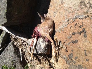
(photo courtesy of Joshua Milberg)
July 25
A mountain lion has been repeatedly spotted by several people just below the upper Chilnualna Falls during the last 24 hours. It is apparently protecting his kill (see photo) nearby.
The carcass of the deer it killed is a few yards from the trail junction, at the top of the Chilnualna Falls trail, where visitors often like to congregate for a picnic or a dip in one the pools along the creek.
Everyone is urged to use caution. Don't hike alone!
VOICES OF YOUTH

Thursday July 26, 2012
at 5:00 PM
Lower Pines Amphitheater, Yosemite Valley
VOICES OF YOUTH
ARC YOSEMITE's 4th Annual Poetry Reading
Join Adventure Risk Challenge in celebrating
VOICES OF YOUTH
Thursday, July 26, 2012
5:00 p.m.
Lower Pines Amphitheater, Yosemite Valley, CA ARC invites you to celebrate a group of extraordinary teens who share their insights on self, family, and community gained during our 40 day summer immersion course.
For more information please email Sarah Cupery Ottley
ARC is a UC Berkeley & UC Merced innovative literacy and leadership program for high school youth, linking wilderness to academics, adventure to leadership, environmental science to literacy and confidence to activism. Our transformative year-round program improves academic skills, exposes youth to a range of natural environments and wilderness experiences, and inspires the confidence they need to envision and accomplish goals, succeed in high school, attend college, and become engaged, empowered citizens.
CLICK TO WATCH A VIDEO OF 2010
Large item pick up
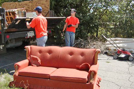
The Mariposa County Public Works will again pick up large items in Wawona on Saturday, September 8, 2012 – the same date as the September WAPOA meeting. The truck will arrive in the Wawona maintenance yard at 9 a.m. that morning and depart at 3 p.m. Large household furnishings, appliances, deck furniture, etc. will be accepted. No hazardous waste or electronics will be accepted. Thanks to Jim Allen for setting this up for Wawona property owners!
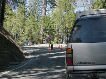
Wawona-Area Road Pavement Preservation (June-September)

Art shows at the Basset Memorial Library
The Bassett Memorial Library is currently hosting two terrific art shows:
Photographs by 11 and 12-year-olds in a focus group visiting Yosemite National Park. These photographs are fresh from their exhibit at the Ansel Adams Gallery in Yosemite Valley and range from close-ups of birds and butterflies to a worm's-eye view of a Giant Sequoia. One picture of the Mist Trail looks like something you'd see in National Geographic.
Pen and Ink Drawings by Joanne Townsend. We all know Joanne, the pretty interpreter from the Pioneer Village and Mariposa Grove Museum, but we didn't know she could draw like that! Detailed drawings of the buildings of the Pioneer History Center rendered with charm and affection - and matted prints are available. These prints or note cards with reproductions of these charming drawings will make great gifts and souvenirs. Joanne has just added a picture of stagecoach driver Burl to the collection.
Taft Toe Prescribed Fire
Yosemite Valley Units: YV-11 and YV-16
Proposed for late July, 2012
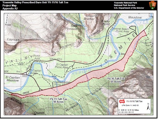
The Taft Toe prescribed fire project includes two units within Yosemite Valley. The 111 acre project is a narrow forested area. The proposed project is approximately 3 miles in length along the South Side Drive of the Valley, and just east of Bridalveil Straight and Sentinel Beach picnic area. Parts of the unit were burned in 1993, 1995 and 1997; some segments have no recorded fire history. It is estimated to take one day to complete this project. Segment boundaries are South Side Drive and the Valley Loop Trail placed to utilize natural and man-made barriers to minimize ground disturbance from hand line construction. The project will be mopped up, patrolled and monitored after the burn.
Smoke will be present. Smoke will be managed by burning during favorable air dispersal conditions, and through notifications and interactions with park employees, visitors and adjacent communities. A burn permit will be received from the Mariposa County Air Pollution Control District prior to ignition. Air quality monitors will be deployed within the Valley and other locations in smoke sensitive areas determined by Yosemite’s air quality manager.
In the absence of fire, shade tolerant trees, such as white fir, and incense cedar, along with forest litter and duff have accumulated to unnatural and unacceptable levels. The purpose of this project is to reduce the accumulation of overabundant small diameter mixed conifer understory tree species, and dead and down woody debris. Additionally, the project, combined with limited mechanical thinning will create more open forest stands, and over time, open past vistas lost due to the over forested areas. A common objective for this project is to use fire as an ecosystem restoration and management tool.
The plan is being reviewed by other park management divisions, including Resources Management and Sciences. The final approval will be made by the park Superintendent. The project is identified in the Yosemite Fire Management and Programmatic Environmental Impact Statement Plan of March 2004.
More updates will be published through the planning process, during the day of ignition and after.
For additional Information
· Fire Information and Education: [email protected]; (209) 375-9574 or (209) 372-0480.
· Yosemite Fire Management Website: http://www.nps.gov/yose/parkmgmt/current_fire.htm.
· Air Quality: http://www.nps.gov/yose/naturescience/aqmonitoring.htm
· Park WEBCAMS: Park http://www.nps.gov/yose/photosmultimedia/webcams.htm
· Facebook: http://www.facebook.com/pages/Yosemite-Wildland-Fire/124632964255395
· Twitter: http://twitter.com/#!/YosemiteFire
