WawonaNews.com - August 2021

Fire Update August 4, 2021
As of August 4th, 2021, Yosemite has had 39 fires started by lightning and 11 human-caused fires for the 2021 calendar year. Fire management has taken on a mix of strategies to suppress, monitor, or maintain these fires throughout Yosemite's naturally fire-adapted ecosystem. On July 31st, lightning storms caused multiple fires, located primarily in the Mather District of Yosemite National Park, along Tioga Road from White Wolf to Aspen Valley, including the Hetch Hetchy area. These 10 fires were all grouped together under one incident name, the Mather Complex. All these fires are being monitored and have a low probability of spread with many natural barriers except for the Tiltill Fire which is being fully suppressed. Additional fires were in the Badger Pass, Glacier Point Road area and near Ostrander Lake.
The other 23 lightning fires not reported in this update have been suppressed, contained, or called natural outs. All fire management actions have adhered to Minimum Impact Suppression Techniques (MIST). This minimizes impacts in the wilderness while allowing the healthy ecological effects of natural fire. Firefighters are routinely monitoring fire behavior on the remaining fires and will continue to engage in management actions as warranted.
Yosemite National Park is a fire-adapted ecosystem. The overall strategy for managing all wildland fires is to provide for the safety of employees and the public and protect and enhance natural and cultural resources.
Mather Complex
Location: Between Aspen Valley and Hetch Hetchy, west of White Wolf.
Number of Fires: 10
Discovery Date: July 31,2021 Size: From .10 to ¼ acres.
Containment: Varies by Fire. Strategy: Confine and Contain/Suppression
Cause: Lightning
Tiltill
Location: North of Hetch Hetchy, Tiltill Valley.
Discovery Date: July 31. 2021 Size: 197 acres
Containment: 5% Strategy: Full Suppression
Cause: Lightning
Mono
Location: Near Ostrander Lake
Discovery Date: July 31. 2021 Size: .10 acres
Containment: 0% Strategy: Monitor
Cause: Lightning
County Line
Location: Near Yosemite Creek Campground Road. 8361 elevation.
Discovery Date: June 28th, 2021 Size: 224 acres
Containment: 100% Strategy: Confine and Contain
Cause: Lightning
Lukens
Location: West of Lukens Lake, North of Tioga Road. 8243 elevation.
Discovery Date: June 28, 2021 Size: 466 acres
Containment: 50% Strategy: Confine and Contain
Cause: Lightning
Stubblefield
Location: Northern end of Yosemite NP, 2000 feet from Pacific Crest Trail (mile marker 982), no threat to trail. 8000 elevation.
Discovery Date: June 28, 2021 Size: 2 acres
Containment: 0% Strategy: Monitor
Cause: Lightning
Wegner
Location: East of Yosemite Creek Picnic Area and east of Tioga Road. 8256 elevation.
Discovery Date: June 28, 2021 Size: .5 acres
Containment: 0% Strategy: Monitor
Cause: Lightning
Half Moon
Location: West of Ten Lakes near Half Moon Meadow. 8256 elevation.
Discovery Date: June 28, 2021 Size: 1.5 acres
Containment: 0% Strategy: Monitor
Cause: Lightning
Yosemite Fires Update 8.4.2021 PDF Printable
Yosemite Fires Map 8.4.2021 PDF Printable
PWR Fire Current Fire Situation (arcgis.com)
-NPS-
- Air Quality: Yosemite Air Quality Page or airnow.gov or airnow.gov/fires
- Trail Closures: https://www.nps.gov/yose/planyourvisit/conditions.htm
- Fire Restrictions: https://www.nps.gov/yose/planyourvisit/firerestrictions.htm
- National Weather Service Yosemite area forecast: www.weather.gov/hanford
- Sign-up for Alerts: go.nps.gov/alert
- Yosemite National Park Fire Information webpage: go.nps.gov/yosefire
- Facebook: @YosemiteFire
- Twitter: @YosemiteFire

Fire Update August 2, 2021
As of August 1st, 2021, Yosemite has had 35 fires started by lightning and 11 human-caused fires for the 2021 calendar year. Fire management has taken on a mix of strategies to suppress, monitor, or maintain these fires throughout Yosemite's naturally fire-adapted ecosystem. On July 31st, lightning storms caused multiple fires, located primarily in the Mather District of Yosemite National Park, along Tioga Road from White Wolf to Aspen Valley, including the Hetch Hetchy area. These 10 fires were all grouped together under one incident name, the Mather Complex. Additional fires were in the Badger Pass area and near Ostrander Lake.
All fires are being monitored and have a low probability of spread with many natural barriers.
The other 19 lightning fires not reported in this update have been suppressed, contained, or called natural outs. All fire management actions have adhered to Minimum Impact Suppression Techniques (MIST). This minimizes impacts in the wilderness while allowing the healthy ecological effects of natural fire. Firefighters are routinely monitoring fire behavior on the remaining fires and will continue to engage in management actions as warranted.
Yosemite National Park is a fire-adapted ecosystem. The overall strategy for managing all wildland fires is to provide for the safety of employees and the public and protect and enhance natural and cultural resources.
Mather Complex
Location: Between Aspen Valley and Hetch Hetchy, west of White Wolf.
Number of Fires: 10
Discovery Date: July 31,2021 Size: From .10 to ¼ acres.
Containment: Varies by Fire. Strategy: Confine and Contain/Suppression
Cause: Lightning
Mono
Location: Near Ostrander Lake
Discovery Date: July 31. 2021 Size: .10 acres
Containment: 0% Strategy: Monitor
Cause: Lightning
County Line
Location: Near Yosemite Creek Campground Road. 8361 elevation.
Discovery Date: June 28th, 2021 Size: 224 acres
Containment: 100% Strategy: Confine and Contain
Cause: Lightning
Lukens
Location: West of Lukens Lake, North of Tioga Road. 8243 elevation.
Discovery Date: June 28, 2021 Size: 466 acres
Containment: 50% Strategy: Confine and Contain
Cause: Lightning
Stubblefield
Location: Northern end of Yosemite NP, 2000 feet from Pacific Crest Trail (mile marker 982), no threat to trail. 8000 elevation.
Discovery Date: June 28, 2021 Size: 2 acres
Containment: 0% Strategy: Monitor
Cause: Lightning
Wegner
Location: East of Yosemite Creek Picnic Area and east of Tioga Road. 8256 elevation.
Discovery Date: June 28, 2021 Size: .5 acres
Containment: 0% Strategy: Monitor
Cause: Lightning
Half Moon
Location: West of Ten Lakes near Half Moon Meadow. 8256 elevation.
Discovery Date: June 28, 2021 Size: 1.5 acres
Containment: 0% Strategy: Monitor
Cause: Lightning
Yosemite Fires MAP 8.2.2021 PDF Printable
Yosemite Fires Map 8.2.2021 PDF Printabl
Yosemite Fires Update 8.2.2021 PDF Printable
PWR Fire Current Fire Situation (arcgis.com)
-NPS-
- Air Quality: Yosemite Air Quality Page or airnow.gov or airnow.gov/fires
- Trail Closures: https://www.nps.gov/yose/planyourvisit/conditions.htm
- Fire Restrictions: https://www.nps.gov/yose/planyourvisit/firerestrictions.htm
- National Weather Service Yosemite area forecast: www.weather.gov/hanford
- Sign-up for Alerts: go.nps.gov/alert
- Yosemite National Park Fire Information webpage: go.nps.gov/yosefire
- Facebook: @YosemiteFire
- Twitter: @YosemiteFire

Indoor Masking in Yosemite
"Yesterday, the Centers for Disease Control and Prevention (CDC) updated its mask guidance for those who are vaccinated against COVID-19 in the wake of a significant surge of the Delta variant among unvaccinated Americans. The recommendations advise fully vaccinated individuals to wear masks indoors in places with high or substantial COVID-19 transmission rates."
The National Park Service has announced that under this new CDC guidance, masks will be required for everyone, vaccinated and unvaccinated inside all public buildings in Yosemite National Park. This new guidance might lead to confusion, as this mandate is not in place for California. It’s important for us to educate visitors that National Parks are under Federal jurisdiction, not state. Doing so will take pressure off of the hospitality staff that will be asked to enforce this new guidance.
Lawmakers Suggest Ways To Curb Overcrowding At National Parks
BY KHRISTOPHER J. BROOKS
JULY 28, 2021 / 5:21 PM / MONEYWATCH - CBS
Yellowstone and Yosemite will continue to be overcrowded unless officials implement a reservation system at more national parks and hire additional staff to handle the influx of visitors, federal lawmakers said Wednesday.
Those were two suggestions made by Angus King, a U.S. Senator from Maine, during a Congressional hearing about how to alleviate overcrowding at the nation's 423 national parks. King also floated the idea of steering people to the "lesser known jewels" in the parks system, like Big Bend National Park in Texas, as well as restricting the number of cars the public can bring to a park.
After months of lockdown during the pandemic, Americans are now flooding the national parks, leading to 4-hour wait times and increased litter along park trails. King said Wednesday he believes visitors are now "loving our parks to death."
"The tension and the paradox we have is we want visitation to our national parks, but we don't want the visitation itself to impair the experience of the national parks or the park itself," King said.
The number of visitors to Dead Horse Point State Park in Utah so far in 2021 has doubled since March 2019, the Wall Street Journal reported. Yellowstone this past Memorial Day weekend saw a 50% increase in the number of cars entering the park, compared with the same holiday weekend in pre-pandemic 2019; and Canyonlands National Park in Utah saw a 30% climb in visitors in April 2021, compared with the same month in 2019, the newspaper reported.
Most of the visitor growth is concentrated in the largest, most popular parks in the system, lawmakers said. Glacier National grew from 2.2 million visits in 2010 to 3 million in 2019. Yellowstone grew from 3.6 million to 4 million in those same years, according to federal data.
National Parks Service officials said visitor counts took a dip in 2020 due to the pandemic, but they expect 2021 to break records.
Overcrowding has prompted some park officials to launch online reservation systems at places like Colorado's Rocky Mountain National Park and Montana's Glacier National Park.
The reservation route works well, according to Kevin Schneider, the superintendent of Maine's Acadia National Park. Schneider said his staff implemented a reservation system this summer and it has created a steadier pace of visitors who want to drive up to Acadia's Cadillac Mountain.
"Visitors understand that there's only 150 parking spots on Cadillac Mountain," Schneider said during the hearing. "We want people to have a really high quality experience and not everybody can be up there at the same time in their cars."
In the parks without reservation systems, visitors say there are too few places to park. One way to eliminate that, King said, is making visitors park their car miles away from a national park then take a free shuttle onto the grounds.
"Often we talk about too many people, but actually we're talking about too many cars," King said, adding that "free visitor shuttles and private partners could allow us to continue growing the number of people in parks while limiting vehicle traffic."
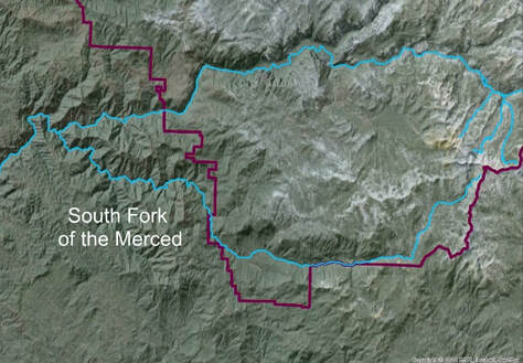
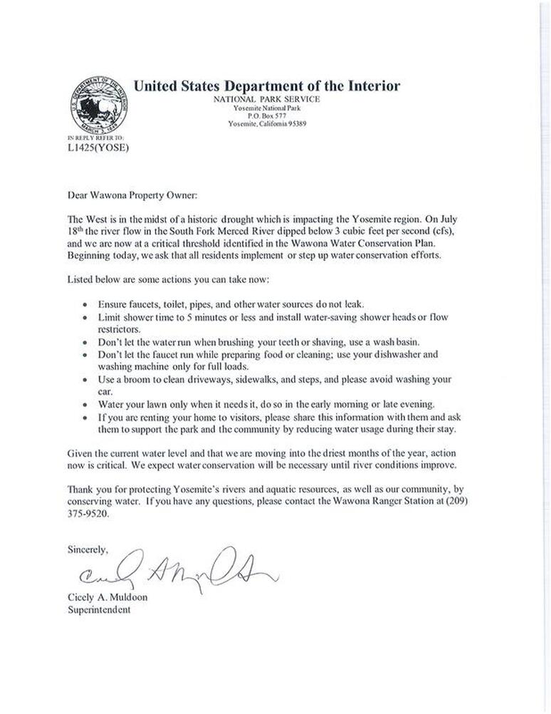
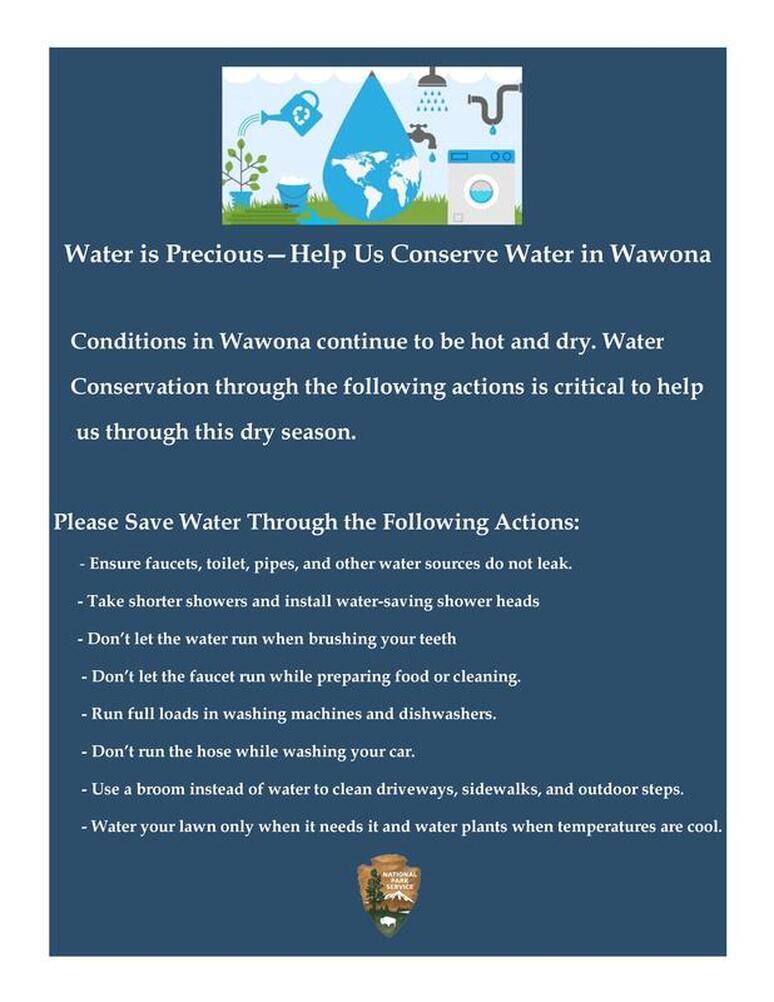
Conserving water for the South Fork is important for many reasons.
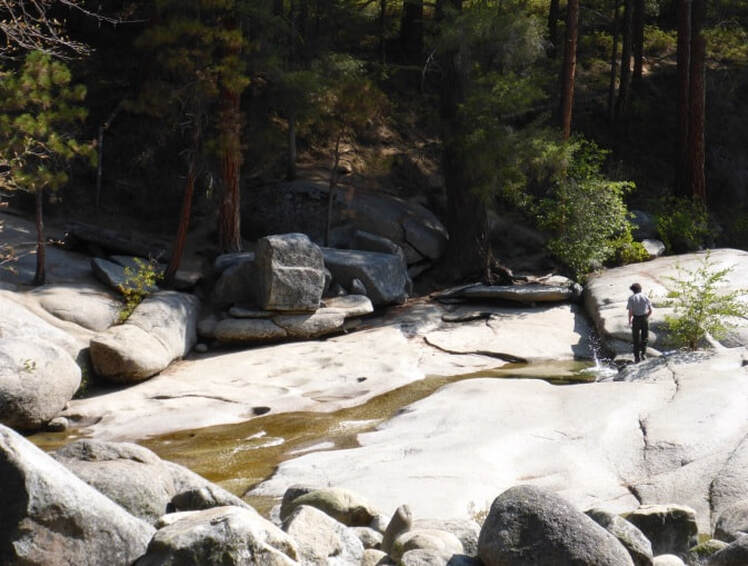
Above Swinging Bridge
in Wawona
Copyright © NPS
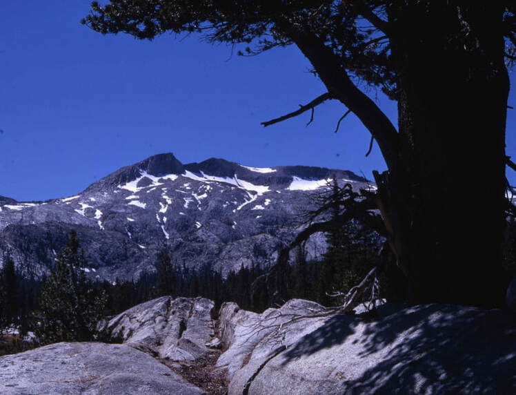 Triple Divide Peak
©Bryan Harry
U. S. National Park Service
Triple Divide Peak
©Bryan Harry
U. S. National Park Service
The South Fork of the Merced River begins on the slopes of Triple Divide Peak and the west-facing slopes of Gale Peak and Sing Peak.
The South Fork flows all the way to join the main stem Merced River near Hites Cove. Along the way, it passes through a beautiful and rugged river canyon
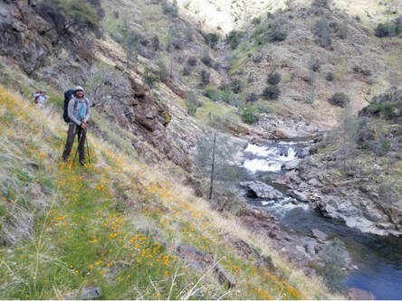
|
South Fork Canyon
©Cat Fong
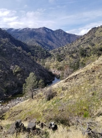
|
The South Fork of the Merced River is a Congressionally designated Wild and Scenic River, which protects the river in a free-flowing condition for the enjoyment of present and future generations.
|
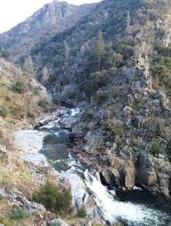
South Fork Canyon
©Cat Fong
|
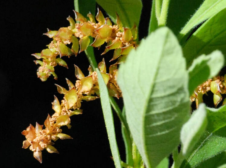 Sierra sweet bay
Copyright © 2015 Barry Breckling
Sierra sweet bay
Copyright © 2015 Barry Breckling
The South Fork Merced River provides habitat for a rare plant, the Sierra sweet bay (Myrica hartwegii). In Yosemite, this plant occurs exclusively on sand bars and riverbanks along the South Fork Merced River downstream from Wawona and along Big Creek.
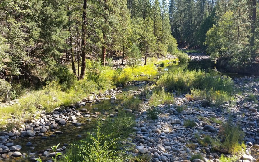 South Fork Merced
Copyright © NPS
South Fork Merced
Copyright © NPS
The river has been declared a Wild Trout Stream by the State of California. The more water in the river, the cooler that temperatures will be. Rainbow trout have increasing stress and mortality as water temperatures near 77F, and we’ve already measured water temperatures at 73F.
All of the plants and animals that depend on the river become more and more stressed as flows drop. Every drop of water counts to ensure that they can survive through this long summer.
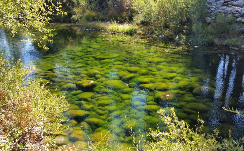
Algae bloom in the South
Fork in 2014
Copyright © NPS
The South Fork began running at low flows very early this year, and there are possibly 2-3 more months of low flows before fall storms boost flows again.
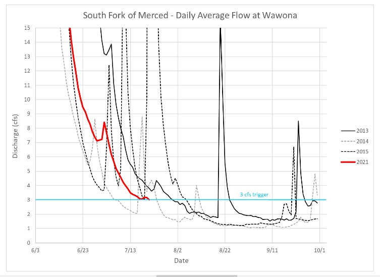
Thank you for doing your part to conserve water and ensure we make the smallest impact possible to the South Fork Merced during the drought.

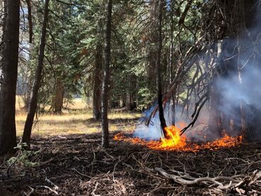
Fire Update July 27, 2021
As of June 28th Yosemite, has had 22 fires started by lightning and six human caused fires for the 2021 fire season. Management has taken on a mix of strategies to suppress, monitor or maintain these fires throughout Yosemite's naturally fire-adapted ecosystem. Crews have completed firing operations on Lukens and County Line fires to increase containment and protect White Wolf Lodge and Campground, and Tioga Road. The Porcupine Fire has been contained with handline and will be monitored. Stubblefield, Wegner, and Half Moon are being monitored and have a low probability of spread with many natural barriers. This minimizes suppression impacts in the wilderness while allowing the healthy ecological effects of natural fire. The other 21 fires not reported on in this update have all been suppressed or were called natural outs. Firefighters are routinely monitoring fire behavior on the remaining seven fires and will continue to engage in management actions as warranted.
Yosemite National Park is a fire-adapted ecosystem. The overall strategy for managing all wildland fires is to provide for the safety of employees and the public and protect and enhance natural and cultural resources.
Hoover
Location: Illilouette drainage 8700 elevation.
Discovery Date: July 19,2021 Size: 59.1 ac.
Containment: 100% Strategy: Suppression
Cause: Lightning
County Line
Location: Near Yosemite Creek Campground Road. 8361 elevation.
Discovery Date: June 28, 2021 Size:224 acres
Containment: 100% Strategy: Confine and Contain
Cause: Lightning
Lukens
Location: West of Lukens Lake, North of Tioga Road. 8243 elevation.
Discovery Date: June 28, 2021 Size: 466 acres
Containment: 50% Strategy: Confine and Contain
Cause: Lightning
Porcupine
Location: Northeast of Porcupine Campground, and Tioga Road. 8210 elevation.
Discovery Date: June 28, 2021 Size:10.8 acres
Containment: 100% Strategy: Suppression
Cause: Lightning
Stubblefield
Location: Northern end of Yosemite NP, 2000 feet from Pacific Crest Trail (mile marker 982), no threat to trail. 8000 elevation.
Discovery Date: June 28, 2021 Size: 2 acres
Containment: 0% Strategy: Monitor
Cause: Lightning
Wegner
Location: East of Yosemite Creek Picnic Area and east of Tioga Road. 8256 elevation.
Discovery Date: June 28, 2021 Size: . 5 acres
Containment: 0% Strategy: Monitor
Cause: Lightning
Half Moon
Location: West of Ten Lakes near Half Moon Meadow. 8256 elevation.
Discovery Date: June 28, 2021 Size: 1.5 acres
Containment: 0% Strategy: Monitor
Cause: Lightning
For the most up-to-date fire information follow Inciweb: https://inciweb.nwcg.gov/
Yosemite Fires Map 7.20.2021 PDF printable
7.27.2021 Yosemite Fires Update PDF Printable
-NPS-
- Air Quality: Yosemite Air Quality Page or airnow.gov or airnow.gov/fires
- Trail Closures: https://www.nps.gov/yose/planyourvisit/conditions.htm
- Fire Restrictions: https://www.nps.gov/yose/planyourvisit/firerestrictions.htm
- National Weather Service Yosemite area forecast: www.weather.gov/hanford
- Sign-up for Alerts: go.nps.gov/alert
- Yosemite National Park Fire Information webpage: go.nps.gov/yosefire
- Facebook: @YosemiteFire
- Twitter: @YosemiteFire
Fire Update July 22
As of June 28th Yosemite has had 21 lightning ignited fires and one human caused fire. On July 19th, a new fire was discovered in the Illilouette drainage. This fire is burning in the 2001 Hoover fire footprint. Crews are on scene constructing handline and using 3 helicopters to slow spread. Crews have completed firing operations on Lukens and County line Fires to increase containment and protect White Wolf and Tioga Road. Porcupine fire has been contained with handline and will be monitored. Stubblefield, Wegner, and Half Moon are being monitored and have low probability of spread with many natural barriers. Hot and dry conditions expected to continue through the week with another round of thunderstorms possible.
Yosemite National Park is a fire-adapted ecosystem. The overall strategy for managing all wildland fires is to provide for the safety of employees and the public and protect and enhance natural and cultural resources.
Hoover
Location: Illilouette drainage 8700 elevation.
Discovery Date: July 19,2021
Size: 45 acres
Containment: 0%
Strategy: Suppression
Cause: Lightning
County Line
Location: Near Yosemite Creek Campground Road. 8361 elevation.
Discovery Date: June 28, 2021
Size: 224 acres
Containment: 85%
Strategy: Confine and Contain
Cause: Lightning
Lukens
Location: West of Lukens Lake, North of Tioga Road. 8243 elevation.
Discovery Date: June 28, 2021
Size: 460 acres
Containment: 50%
Strategy: Confine and Contain
Cause: Lightning
Porcupine
Location: Northeast of Porcupine Campground, and Tioga Road. 8210 elevation.
Discovery Date: June 28, 2021
Size: 10.8 acres
Containment: 100%
Strategy: Suppression
Cause: Lightning
Stubblefield
Location: Northern end of Yosemite NP, 2000 feet from Pacific Crest Trail (mile marker 982), no threat to trail. 8000 elevation.
Discovery Date: June 28, 2021
Size: 2 acres
Containment: 0%
Strategy: Monitor
Cause: Lightning
Wegner
Location: East of Yosemite Creek Picnic Area and east of Tioga Road. 8256 elevation.
Discovery Date: June 28, 2021
Size: .25 acre
Containment: 0%
Strategy: Monitor
Cause: Lightning
Half Moon
Location: West of Ten Lakes near Half Moon Meadow. 8256 elevation.
Discovery Date: June 28, 2021
Size: 1 acre
Containment: 0%
Strategy: Monitor
Cause: Lightning
Fork
Location: One mile southeast of Mount Starr King. 8500 elevation.
Discovery Date: June 28, 2021
Size: 12 acres
Containment: 100% Last report unless conditions change
Strategy: Confine and Contain
Cause: Lightning
Lost
Location: Northeast Starr King Meadow. 8700 elevation.
Discovery Date: July 6, 2021
Size: .25 acre
Containment: 100% Last report unless conditions change
Strategy: Suppression
Cause: Lightning
Quartzite
Location: West of Quartzsite Peak. 8781 elevation.
Discovery Date: June 29, 2021
Size: .5 acre
Containment: 100% Last report unless conditions change
Strategy: Monitor
Cause: Lightning
King
Location: South of Nevada Falls, north of Mount Starr King. 7220 elevation.
Discovery Date: June 29, 2021
Size: 10 acres
Containment: 100% Last report unless conditions change
Strategy: Suppression
Cause: Lightning
For the most up-to-date fire information follow Inciweb: https://inciweb.nwcg.gov/
Yosemite Fires Map 7.20.2021 PDF printable
7.22.2021 Yosemite Fires Update PDF printable
-NPS-
- Air Quality: Yosemite Air Quality Page or airnow.gov or airnow.gov/fires
- Trail Closures: https://www.nps.gov/yose/planyourvisit/conditions.htm
- Fire Restrictions: https://www.nps.gov/yose/planyourvisit/firerestrictions.htm
- National Weather Service Yosemite area forecast: www.weather.gov/hanford
- Sign-up for Alerts: go.nps.gov/alert
- Yosemite National Park Fire Information webpage: go.nps.gov/yosefire
- Facebook: @YosemiteFire
- Twitter: @YosemiteFire
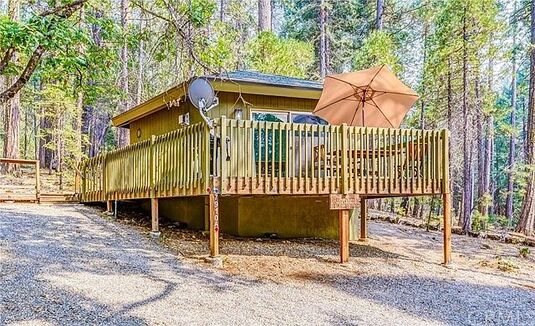
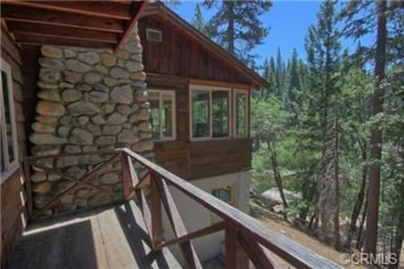
New House For Sale in Wawona
$452,000
1 bd1 ba480 sqft7910 Forest, Yosemite National Park, CA 95389
Click here for more info
$452,000
1 bd1 ba480 sqft7910 Forest, Yosemite National Park, CA 95389
Click here for more info
Keep Wawona Bears Off The Bucket List
Yosemite Fires Update July 16
On Monday, June 28, 2021, through July 2, thunderstorms developed over Yosemite National Park, creating lightning that ignited 19 fires. Fire managers have been assessing all fires for an appropriate response. Ten fires have been contained due to location and spread potential. There are six remaining fires that are burning in high elevation areas located in wilderness ranging from 7,000 to 9,700 feet and are actively being monitored. The Lukens Fire and County Line Fire are being suppressed using roads and trails to contain and confine, with additional burning to secure these fires into the Wolf and Blue Jay fire footprints from 2020.
Travelers along Tioga Road may experience delays with one-way traffic from White Wolf Junction to Mc Swain Summit. Firefighters and fire equipment will be working on this section of Tioga Road.
Yosemite National Park is a fire-adapted ecosystem. The overall strategy for managing all wildland fires is to provide for the safety of employees and the public and protect and enhance natural and cultural resources.
King
Location: South of Nevada Falls, north of Mount Starr King. 7220 elevation.
Discovery Date: June 29, 2021 Size: 10 acres
Containment: 100% Strategy: Suppression
Cause: Lightning
Quartzite
Location: West of Quartzsite Peak. 8781 elevation.
Discovery Date: June 29, 2021 Size: .5 acre
Containment: 0% Strategy: Monitor
Cause: Lightning
Stubblefield
Location: Northern end of Yosemite NP, 2000 feet from Pacific Crest Trail (mile marker 982), no threat to trail. 8000 elevation.
Discovery Date: June 28, 2021 Size: 2 acres
Containment: 0% Strategy: Monitor
Cause: Lightning
Porcupine
Location: Northeast of Porcupine Campground, and Tioga Road. 8210 elevation.
Discovery Date: June 28, 2021 Size: 3.7 acres
Containment: 0% Strategy: Monitor
Cause: Lightning
Hidden
Location: Northwest of Olmsted Point, Tioga Road. 9017 elevation.
Discovery Date: June 28, 2021 Size: .1 acre
Containment: 0% Strategy: Monitor
Cause: Lightning
County Line
Location: Near Yosemite Creek Campground Road. 8361 elevation.
Discovery Date: June 28, 2021 Size: 170 acres
Containment: 60% Strategy: Confine and Contain
Cause: Lightning
Lukens
Location: West of Lukens Lake, North of Tioga Road. 8243 elevation.
Discovery Date: June 28, 2021 Size: 450 acres
Containment: 0% Strategy: Confine and Contain
Cause: Lightning
Wegner
Location: East of Yosemite Creek Picnic Area and east of Tioga Road. 8256 elevation.
Discovery Date: June 28, 2021 Size: .25 acre
Containment: 0% Strategy: Monitor
Cause: Lightning
Half Moon
Location: West of Ten Lakes near Half Moon Meadow. 8256 elevation.
Discovery Date: June 28, 2021 Size: .1 acre
Containment: 0% Strategy: Monitor
Cause: Lightning
Fork
Location: One mile southeast of Mount Starr King. 8500 elevation.
Discovery Date: June 28, 2021 Size: 12 acres
Containment: 100% Strategy: Confine and Contain
Cause: Lightning
Lost
Location: Northeast Starr King Meadow. 8700 elevation.
Discovery Date: July 6, 2021 Size: .25 acre
Containment: 100% Strategy: Suppression
Cause: Lightning
Snow
Location: May Lake Trailhead, near Tioga Road. 8600 elevation.
Discovery Date: July 14, 2021 Size: .1 acre
Containment: 100% Strategy: Suppression
Cause: Lightning
Yosemite National Park is a fire-adapted ecosystem. The overall strategy for managing all wildland fires is to provide for the safety of employees and the public and protect and enhance natural and cultural resources.
For the most up-to-date fire information follow Inciweb: https://inciweb.nwcg.gov/
Yosemite Fires Map PDF download
Yosemite Fires Update 7.16.2021 PDF dowanload
-NPS-
- Air Quality: Yosemite Air Quality Page or airnow.gov or airnow.gov/fires
- Trail Closures: https://www.nps.gov/yose/planyourvisit/conditions.htm
- Fire Restrictions: https://www.nps.gov/yose/planyourvisit/firerestrictions.htm
- National Weather Service Yosemite area forecast: www.weather.gov/hanford
- Sign-up for Alerts: go.nps.gov/alert
- Yosemite National Park Fire Information webpage: go.nps.gov/yosefire
- Facebook: @YosemiteFire
- Twitter: @YosemiteFire
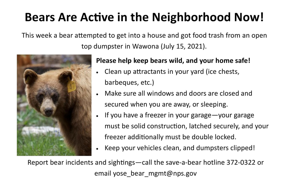
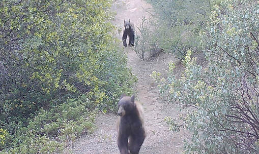 Photo taken in Wawona July 12
Bears in Wawona
There are currently at least 2 bears active in Wawona now. One has gotten food from dumpsters and one was possibly in a house. If you see a bear in the residential area, please:
1. Scare it away. Make it uncomfortable around people. Throw things. Stomp around. Yell.
2. Report it to dispatch at 209 379 1992. Tell them your location, a description of the bear, and ask them to send someone.
3. Be ever vigilant about food, trash, and scented items. Clean up your act. Put away coolers inside. Don't dump bacon grease or other attractants outside.
The survival of these bears is up to you and how well you comply with food storage regulations. These two are not on a good track right now. If they are closer than 25 or 50 yards from you, get primal and scare them away.
Also, if you see damaged dumpsters or missing clips please report to Recology (number on the bins) and Mariposa County.
HL Schledge
RIVER FIRE UPDATE : Yosemite Not Threatened
The River Fire has grown to 9,500 acres, but is now 21% contained. Despite some news reports connecting the fire to the park, Yosemite is not threatened and we are doing our best to indicate that to potential and incoming visitors.
We attended this morning’s CAL FIRE briefing and are pleased to report that officials appear cautiously optimistic about getting River Fire contained. Containment lines have been constructed around the fire and the plan has “been perfectly executed”. Crews are working to keep the fire out of the Chowchilla River Drainage.
Here are some useful links for more information:
CAL FIRE Incident Page
Mt. Bullion and Deadwood webcams
Yosemite Webcams
Fire and Smoke Map
We will continue to monitor the situation and send out additional updates as things progress.
We are grateful to the amazing firefighters working to hold the line and hope that they all stay safe!
- YMCTB Staff
|
For Sale By Owner
$1,499,000 3 bd2 ba1,200 sqft2577 Chilnualna Ln, Yosemite National Park, CA 95389 click here for more info |
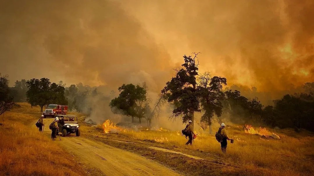
River Fire: Wildfire grows to 9,500 acres, 15% containment; latest evacuation orders
Tuesday, July 13, 2021 7:34AM
The firefight rages on in Madera and Mariposa counties as the River Fire continued to grow overnight, spreading to 9,500 acres.
Containment over the wildfire also grew to 15%, CAL FIRE said Tuesday morning.
The fire broke out Sunday afternoon along Oak Grove Road and Oak Grove School Road in Mariposa County. It's about eight miles south of Bootjack and 14 miles north of Raymond.
Eight structures have been destroyed, and the flames are still threatening about 600 structures. Officials did not release details about where the destroyed structures were located.
Monday evening, the Mariposa County Sheriff's Office said that all evacuation orders in Mariposa County had been reduced to a fire advisory.
Deputies are asking residents to keep an eye on the fire activity and be prepared to leave if conditions change. You are still asked to avoid the area.
Click here for a map of the evacuated areas.
Evacuation Orders
An evacuation warning has been issued for the following area:
The firefight rages on in Madera and Mariposa counties as the River Fire continued to grow overnight, spreading to 9,500 acres.
Containment over the wildfire also grew to 15%, CAL FIRE said Tuesday morning.
The fire broke out Sunday afternoon along Oak Grove Road and Oak Grove School Road in Mariposa County. It's about eight miles south of Bootjack and 14 miles north of Raymond.
Eight structures have been destroyed, and the flames are still threatening about 600 structures. Officials did not release details about where the destroyed structures were located.
Monday evening, the Mariposa County Sheriff's Office said that all evacuation orders in Mariposa County had been reduced to a fire advisory.
Deputies are asking residents to keep an eye on the fire activity and be prepared to leave if conditions change. You are still asked to avoid the area.
Click here for a map of the evacuated areas.
Evacuation Orders
- Road 800
- Road 810
- Road 812
- Road 600
- Apache Road to 612 both sides
- Road 600 between Apache Ranch and Blazing Saddle Trail and JWP Ranch Road
An evacuation warning has been issued for the following area:
- 1 mile east of Rd 600, 1 mile north of Rd 600
- A temporary evacuation point has been established at New Life Christian Fellowship at 5089 Cole Road, Mariposa, CA 95338. If residents in the area have questions, they can call CAL FIRE at 844-668-3473.
Madera County residents are urged to sign up for alerts on evacuation orders and warnings here.
Mariposa County residents are urged to sign up for alerts here.
Nearly 1,300 fire personnel are battling the fast-moving flames. Firefighters are attacking the flames from the ground and air.
Seven helicopters helped with water drops on Monday while crews on the ground worked to build control lines.
CAL FIRE officials said the high heat and low humidity have made things difficult.
The quick-moving fire is all too familiar for local residents after last year's Creek Fire.
"Yesterday we were in Mariposa just eating, and we saw a firetruck go by. It's like repeated PTSD. The second one went by... we need to go so, we finished up our meal and went," said Bob Milner.
Pacifica Gas and Electric has shut off power to about 170 customers for firefighter safety in the area.
CAL FIRE investigators are looking into how the fire started.
River Fire Perimeter Map
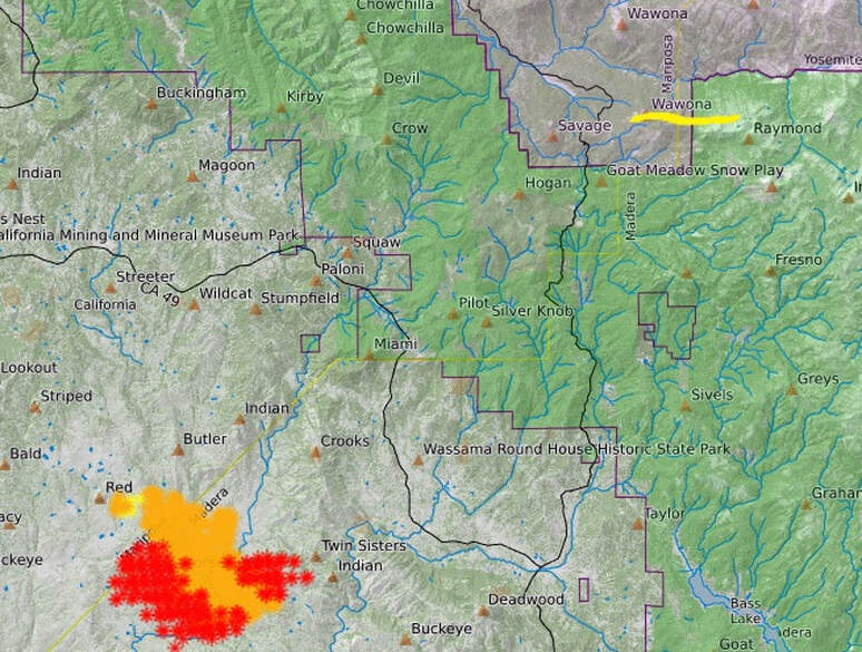
Perimeter map of River Fire. Wawona is highlighted on top, right for reference. Red spots represent the most intense heat areas. Click on the image to see an updated perimeter map.
