WawonaNews.com - August 2013
Bulky Item Pick Up Reminder

Bulky item pickup is scheduled for September 14th.
John Carrier
Mariposa County
Supervisor District V
5100 Bullion St.
PO Box 784
Mariposa, CA 95338
209-966-3222
209-966-5147 Fax
[email protected]
John Carrier
Mariposa County
Supervisor District V
5100 Bullion St.
PO Box 784
Mariposa, CA 95338
209-966-3222
209-966-5147 Fax
[email protected]
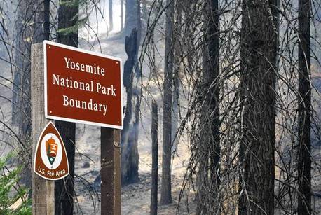
Fire in Yosemite offers forest management lessons
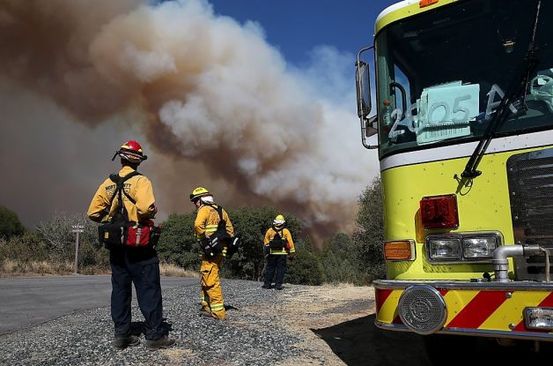
Peter Fimrite - SF Chronicle
The danger of catastrophic fire was already clear to Scott Stephens when flames erupted almost on cue and chased his team of UC Berkeley researchers out of the Stanislaus National Forest.
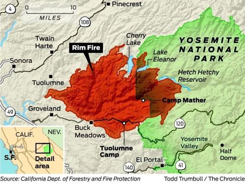
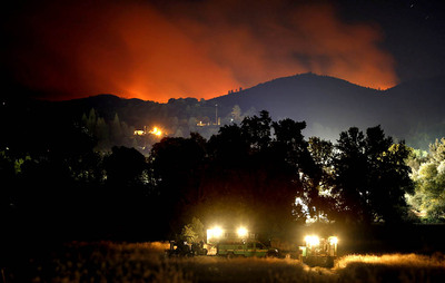
The enormous Rim Fire, which started on Aug. 17 and has now blackened 343 square miles of forest in and around Yosemite National Park, was almost licking at his heels.
"I was thinking before the fire that if we ever get a fire in here, most of the old trees will be killed," said Stephens, the university's chief fire science expert. "I think that has happened."
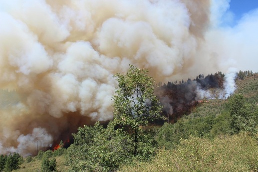
The Rim Fire, now the largest fire in recorded Sierra Nevada history, is a treasure trove of information for scientists studying the effects of forest management techniques. That's because it burned through a variety of different landscapes, including chaparral-covered canyons, newly planted tree plots, previously burned areas and dense forests.
The key question is what happened on Aug. 22 and 23, when a 200-foot wall of flames burned almost 90,000 acres.
"Almost half of this very, very large fire happened in just two days," said Max Moritz, a fire scientist at the UC Berkeley Cooperative Extension. "If you are a scientist, that is very interesting."
Big increase in tree density
A large part of the answer may be found in Stephens' interrupted expedition. His four-person research team was in the process of measuring tree diameters and densities on 15,000 acres that had been studied by the U.S. Forest Service in 1911.
The group found as many as 400 trees per acre on the land. That's compared with between 60 and 90 trees per acre in 1911. There was also between 30 and 40 tons of woody debris per acre on the forest floor, compared with 6 to 8 tons 92 years ago, Stephens said. Besides the dramatic increase in tree density, the researchers found more undergrowth species and, although there were still many old growth trees, the average size of the trees was smaller than in 1911, he said.
"We know the last fire in that area was in about 1905. That's 100 years without fire," Stephens said. "If you don't clear trees and brush and do some prescribed burning, you are eventually going to get a very closed forest that is very dense."
Fires have historically been common in California, where burning actually prompts many native plants and trees to release more seeds. American Indians used to purposely set fires in an effort to clear out excess brush and prompt new growth, but the large trees normally survived. Experts say many areas of California, where fires used to burn every 10 or 15 years, are now more vulnerable to catastrophic fire because the forests are overgrown.
Intense fires kill big trees
High-intensity fires generally kill the big trees, which Stephens said is why forest thinning, prescribed burns, chipping of excess wood and other forest management techniques are necessary.
"All those things would reduce tree mortality in wildfires," he said. "It is something that could probably reduce mortality in fires by 50 percent."
The problem is that thinning is difficult in places where there are towns, utility corridors, highways and timber interests blocking the way, and tree thinning and brush-clearing operations are expensive.
"We end up in court a lot on these projects because, lets face it, people don't like chainsaws," said Hugh Safford, a forest service vegetation and fire ecologist.
As it is, Stephens fears the 350- to 500-year-old Douglas fir, sugar and ponderosa pine trees he documented in the research area were incinerated.
Logging, fire suppression and a lack of management over the years all played a role in the Rim Fire, experts say, but there are several other factors that contributed to the disaster, including strong winds and extremely dry conditions.
Forest service officials said the fire started under windy conditions in a chaparral-covered canyon near Groveland, burned over steep terrain into the area where Stephens was conducting his research and then went wild, climbing up the tree canopy and tripling in size.
The fire scorched tens of thousands of acres in the Stanislaus forest that had previously burned in 1987. That area was replanted with ponderosa pines, Safford said, but most of the plots had not been thinned.
"The Forest Service was slowly trying to reduce the density, but when you drove through that area you could see that had not happened in a large area, probably less than 10 percent," Safford said. "It's sad to have so many trees regenerate and then have them killed in another fire."
Slowed at Yosemite line
The speed and intensity of the fire slowed dramatically when it crossed the Yosemite boundary on Aug. 23 because, experts believe, the National Park Service has a policy of allowing lightning-caused fires to burn out. Fuel densities in the Yosemite area are much lower than in the Stanislaus, officials said, because several fires have burned through the area, including 1996's 47,000-acre Ackerson fire, near Hetch Hetchy.
"The whole west side of Yosemite National Park is a mosaic of managed fire," Safford said. In that way, "Yosemite is the world's best experimental landscape."
Climate change
Scientists have long predicted an increase in fire intensity and frequency in California as a result of climate change. The Rim Fire is one of a higher-than-average number of wildfires in the past two years. The worst year on record was in 2008, when 6,255 fires burned nearly 1.6 million acres in California. Fire behavior analysts say the conditions this year are eerily similar to the way they were then.
"It is hard to point to any two or three years in a row and say, gosh, this is due to climate change, but the conditions now have a lot of characteristics of what we would expect from climate change," Moritz said. "We are seeing some record-breaking fire years."
There will undoubtedly be a lot of debate over causes and solutions as scientists study the Rim Fire, but fire will always be a part of California's future and, Stephens said, lessons must be learned.
"We do really expect more fire in California because of climate change," Stephens said. "The question is, can we do treatments today that will basically set the system up so that when fires do burn, their impact will be reduced? The answer to that is, yes we can."
Peter Fimrite is a San Francisco Chronicle staff writer. E-mail: [email protected]
Rim Fire 60% Contained, Smoke Conditions Improve
By Lisa Fernandez | NBC News | Monday, Sep 2, 2013 | Updated 12:54 PM PDT
Firefighters battling the stubborn Rim Fire near Yosemite finally contained more than half of the wildfire on Monday, reaching 60 percent containment.
Cal Fire spokesman Daniel Berlant issued the good news early on Labor Day, adding that the Rim Fire has now charred 228, 670 acres, or 357 square miles – more than seven times the size of San Francisco.
The containment should only grow, he added, as the weather forecast for Northern California should see cooler temperatures and even some possible rain. Still, the expected full containment date is Sept. 20.
The fire has been burning since Aug. 17 in the Stanislaus National Forest. According to one fire official who is not officially charged with investigating the fire, it's possible that illegal marijuana growers could be to blame.
Todd McNeal, fire chief in the town of Twain Harte, west of Yosemite, said at an Aug. 23 community meeting, captured on YouTube, that officials "know it's human caused, there’s no lightning in the area. … (We) highly suspect that it might be some sort of illicit grove, marijuana grow-type thing.” His comments come at the 6:24 minute mark of a 20-minute briefing, and he underscores there is no official cause, just that it's "highly suspect."
McNeal did not return a phone call Monday when NBC Bay Area called seeking comment.
Officially, however, there is no cause listed for the fire according to the U.S. Forest Service. On Monday, Rim Fire spokesman Brian Haines told NBC Bay Area that the investigators have still not determine what sparked the blaze, and at this point, the marijuana theory is just "an opinion."
He did say that federal investigators had pinpointed the origin of the fire: The Jawbone Ridge in Tuolumne County, which sits on Groveland Ranger District land, at the point where the Clavey River and the Tuolumne Wild and Scenic River meet up. That spot, he said, is the focus of the investigation.
As of Monday, the Rim Fire remained the 4th largest wildfire in California's history, edging out a 222,777-acre fire that burned in Ventura County in 1932. The third largest fire is now the Zaca fire in Santa Barbara, which burned more than 240,000 acres in July 2007.
The Rim Fire is just one of seven major wildfires being battled across the state. Berlant said that a new fire ignited Saturday on the Tule Indian Reservation in Tulare County, burning 250 acres.
Also on Saturday, the smoke in Yosemite Valley was so thick it was difficult to see Yosemite Park's Half Dome. On Sunday, however, air quality in the Valley improved, but people there are still being told to avoid any strenuous outdoor activity.
Some of the nearly 5,000 firefighters, including strike teams from San Francisco and Mountain View, returned home this weekend after spending days on the fire lines.
MORE: Rim Fire Incident Command Page
Despite the containment, a total of 5,500 structures still remained threatened, and so far, 111 buildings were damaged - 11 of them were homes, despite earlier reports that 31 homes had burned.
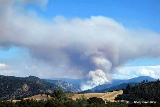
Rim Fire Smoke Reaches Valley Floor, Wawona, Fresno
Stephanie Stone
More: Bio, E-mail, Facebook, Twitter, Articles by Stephanie Stone, News Team FRESNO, Calif. (KFSN) -- Aug. 31
More than 4,000 firefighters are battling the flames around Yosemite and it is expected to burn for a few more weeks. It has prompted the Valley Air District to issue a Health Caution, as the smoke has now crept into the Valley floor.
The smoke many Valley residents saw and smelled Monday was attributed to the Rim Fire. A spokeswoman for the Valley Air District says if you can smell it, you're affected and should take precaution.
Jaime Holt, with the Valley Air District says, "We've actually had inspectors call in and let us know they are seeing it as they're doing their work, we've had a couple schools call us."
At first most everyone thought it was just an odd looking, discolored haze, one that, after a few hours started to fester and now, smell. "Some reporting a streak of smoke going across the sky. That smoke from the Rim Fire, that's gonna come in and it will have nowhere to go and more will come in in the evening hours, it'll be closer to the Valley floor," Holt said.
For pilots at Chandler Airport in Southwest Fresno, it meant a change in direction.
Wayne Bush, a flight instructor at Chandler Airport, says "We thought we were just going to train, it looked like it was fairly benign, but as we got in, we thought we don't want to be breathing all of this, so we climbed up above it. " Bush had to fly 3,000 feet above the smoke.
 View on Wawona webcam at 11 am, Aug. 31
"It was very thick, visibility was only five miles, usually it's clear and unlimited, in that area, when you get below five miles you start having trouble navigating by visual references on the ground," Bush said.
According to the Valley Air District, the stench and that smoke is only going to get thicker until we get a new weather pattern. "People may wake up in the morning might have sore throat, itchy eyes, runny nose, that's because the smoke is making its way down to the Valley floor."
Fresno Firefighters are also getting calls from people reporting thick smoke. After investigating, fire fighters were able to attribute a lot of those calls to the Rim Fire. Those with health issues are urged to take precautionary measures.
The Rim Fire in Tuolumne County has prompted local air officials to issue a health cautionary statement for smoke impacts in six Valley air basin counties: San Joaquin, Stanislaus, Merced, Madera, Fresno and Tulare, especially the foothill and mountain areas. The caution is in place through Labor Day weekend, when visitors will be traveling to the Sierra Nevada.
If winds should shift, Kings and the Valley portion of Kern counties may become affected, as well.
"Our rule of thumb is, if you can see and smell smoke, you are probably being affected," said Samir Sheikh, the Air District's director of air quality analysis. In that event, air officials advise residents to take whatever health precautions their conditions warrant.
Smoke from fires produces fine-particulate matter (PM2.5), which can cause serious health problems including lung disease, asthma attacks and increased risk of heart attacks and stroke. Where conditions warrant, people with heart or lung disease should follow their doctors' advice for dealing with episodes of particulate exposure. Additionally, older adults and children should avoid prolonged exposure or heavy exertion, depending on their local conditions.
Residents can check the nearest air monitor to their location to determine localized air-quality conditions. Visit the Real-time Air Advisory Network page on the District's website to subscribe for free: http://www.valleyair.org/Programs/RAAN/raan_landing.htm. They can also receive updated fire information at: http://www.inciweb.org/incident/3552/.
For more information, visit www.valleyair.org or call a District office in Fresno (559-230-6000), Modesto (209-557-6400) or Bakersfield (661-381-1809).
(Copyright ©2013 KFSN-TV/DT. All Rights Reserved.)
Rim Fire By the Numbers
After 14 days of fighting the Rim Fire in and near Yosemite National Park, the fire continues to spread to the north, east, and south. Firefighters are working on indirect firelines and are conducting burnout and other firing operations out ahead of the fire where they can, including south of Highway 120 north of Old Yosemite Road.
The fire has now burned 201,894 acres and the Incident Commander is calling it 32 percent contained. Their estimated containment date is September 20. A huge number of personnel, 4,931, are assigned to the fire. We can’t remember a fire that had that many people working on it.
- Acreage: 201,894
- Largest fire in the United States to date in 2013·
- No. 1-ranked on national firefighting priority list
- Fifth largest fire in California history
- Second largest U.S. fire to date in 2013: Lime Hills Fire, Alaska 201,809 acres
- States that have sent firefighters or other personnel: 41 and the District of Columbia
- Uncontrolled fire edge: 96.8 miles
- Completed containment line: 65.5 miles Completed dozer line: 105.7 miles
- Total aviation hours: 14,400
- Water dropped: 1.4 million gallons
- Fire retardant dropped: 1.7 million gallons
- Proportion of the fire burning within the Stanislaus National Forest: 74.6 percent
- Proportion of the fire burning in Yosemite National Park: 24 percent
- Proportion of the fire burning on state and private property: 1.4
- Proportion of the Stanislaus National Forest within the fire perimeter: 16.8 percent
- Proportion of Yosemite National Park within the fire perimeter: 6.4 percent
- Size of the fire area: Larger than the land area of San Francisco, Oakland and San Jose combined
- Hot meals served: Breakfasts: 15,453 Dinners: 16,049
- Pounds of firefighter laundry washed: 9,538.75
- Burned or damaged guard rail posts to be replaced on Highway 120: 800
- Damaged trees adjacent to power lines to be removed by Pacific Gas and Electric: 7,000
Let it burn? Yosemite officials won't say that but it's policy
Unless a naturally occurring fire threatens lives or structures, Yosemite and other national parks are likely to let nature run its course.
By Julie Cart August 29, 2013, 9:12 p.m.
Los Angeles Times
GROVELAND, Calif. — As the massive Rim fire roared out of the Stanislaus National Forest and deeper into Yosemite National Park this week, public attention rose sharply.
But the intensity of firefighting did not.
That's because part of the blaze had crossed into the jurisdiction of the National Park Service, which has a more restrained approach to managing wildfires than other federal, state and local fire agencies battling the 300-square-mile blaze.
Officials estimate that it will be fully contained in two or three weeks, but it is expected to keep smoldering for weeks longer and won't be truly out for months.
"This fire will burn until the first rains or until the snow flies," said Lee Bentley, a spokesman for the U.S. Forest Service.
Although the 4,900 firefighters here operate under a unified command, the park service has a very different firefighting philosophy from that of the forest service or the California Department of Forestry and Fire Protection.
The portion of the Rim fire burning outside the park is fought aggressively by the forest service and Cal Fire. Bulldozers rip fire lines across the landscape, and crews fell trees and set protective backfires. Helicopters and tanker airplanes drop water and retardant.
"We want to send as much equipment to a fire as we can," said Cal Fire spokesman Daniel Berlant. "Our goal is to put it out early and avoid having a large fire."
But inside parks, a policy often called "fire use" accepts fire as a naturally occurring process and often a useful tool.
Park fire managers suppress blazes that endanger people or threaten structures and resources. Fires in tourist-heavy Yosemite Valley, for instance, are "very, very controlled," said Tom Medema, Yosemite's chief of interpretation and education.
Otherwise, park officials prefer to herd fires where they want them to go and allow blazes to burn out on their own.
It's a science-based approach that serves the same function as off-season forest thinning and controlled burns. But those arguments often fail to stand up to public distaste for trees burning in beloved national parks.
"People will say, 'I've planned my whole life for a trip to Yosemite and I can't even see Half Dome,'" Medema said. "I totally understand that."
Public perception is fed by a belief widely held in the 1940s, '50s and '60s that fire is bad, period. The park service has worked hard to change that perception, and Medema said the agency has made progress.
As the Rim fire invades Yosemite, park officials will pore over maps that reflect the historic fire return interval — the frequency that natural fire goes through an area. Every acre of the park is mapped in this fashion, and each has a fire "prescription."
So, for instance, when the blaze hits an area of the park where fire returns every 12 years — but hasn't been burned in 16 years — the prescription for that area is to let it burn.
The park service's distinction between natural and human-caused fires is not one that other agencies make. "It doesn't matter how the fire started. We are going to suppress it and put it out," Berlant said.
Jumping on fires quickly makes sense given Cal Fire's mandate. The state agency protects 31 million acres of mostly private land and millions of acres of forests owned by timber companies, and it has the responsibility of protecting hundreds of small communities from wildfires.
Cal Fire's muscular response to fire is reflected in its arsenal: It has the largest fleet of firefighting aircraft in the world and owns 23 large tankers. In comparison, the federal government has nine tanker aircraft on contract.
It is not likely that anyone will allow the Rim fire to consume Yosemite in the manner that catastrophic fires ravaged Yellowstone National Park in 1988, the precursor to today's era of mega-fires. About 706,000 acres in Yellowstone burned, or nearly a third of the park. Before those blazes, the biggest known fire in Yellowstone was one in 1886 that burned out after destroying 25,000 acres.
The Yellowstone fires in 1988, most of which were touched off by lightning, began in June on a landscape hollowed out by drought. Park officials monitored the complex of fires and allowed them to burn unimpeded through the park for nearly a month. Haze from the fires reached the Midwest.
Amid mounting criticism, park officials patiently explained the agency's "let it burn" approach, to little avail.
"In the national parks, a major part of our job is to protect a place so that nature can work," Yellowstone spokesman Al Nash said this week. "In many large parks in the West, fire is one way that nature works."
But the park's trial by fire brought about a reexamination. "It prompted everyone to step back and look at their approach," Nash said.
Eventually, the Yellowstone fires required 25,000 personnel, including two battalions of Marines, and more than 10 million gallons of water.
The last flame was extinguished in mid-November 1988 — by rain and snow. The cost of the five-month firefighting effort came to $120 million.
And despite the arm-waving about the park service's seemingly laissez-faire approach to fires, the policy remains in place.
But don't expect to hear any park service employee utter "let it burn" again.
"Those are certainly three words you will never hear me say," Nash said.
[email protected]
Times staff writer Tony Barboza in Groveland contributed to this report.
Updates on Rim Fire

Click on the Sierra Sun Times image for updates on the Rim Fire
Predator Drones Combat Fire in Yosemite
Visit NBCNews.com for breaking news, world news, and news about the economy
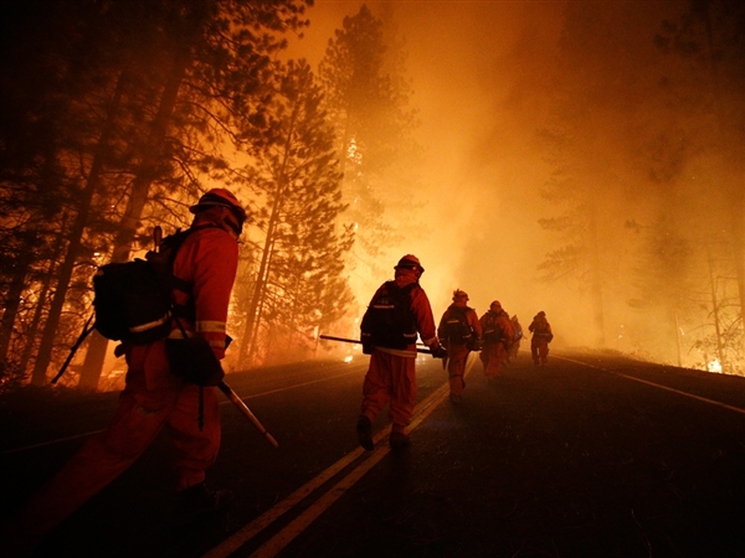
The California Air National Guard and Cal Fire have launched predator drones roughly 300 miles from the massive Rim fire in Yosemite this morning in hopes of battling the massive blaze with technology. The data from the drones will pinpoint hot spots and track flames, and will be sent directly to the some 5,000 firefighters on the ground.
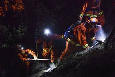
Firefighting felons: Hundreds of inmates battling Rim Fire
Inmate firefighters, who are paid $1 an hour as part of California's conservation prison-camp program, work the Rim Fire threatening Yosemite.
By Tracy Connor, Staff Writer, NBC News - August 30
They swing the same Pulaskis, buzz the same chainsaws and face the same dangers.
But 673 of the wildland firefighters battling the ferocious blaze around Yosemite National Park have something that other hotshot crew members do not: a prison identification number.
They're part of California's conservation camp program, which takes convicts out of jail cells and puts them on the front lines of wildfires, where they earn $1 an hour cutting containment lines that keep flames from spreading.
"They are in the thick of it," said Capt. Jorge Santana of the California Department of Corrections and Rehabilitation.
The agency has sent 621 men and 52 women to tackle the so-called Rim Fire, which has engulfed nearly 300 square miles of land in 12 days. More have been deployed to 20 other fires across the state.
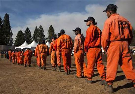 Inmate firefighters line up for dinner at the Rim Fire camp near
Buck Meadows, Calif.
Inmate firefighters line up for dinner at the Rim Fire camp near
Buck Meadows, Calif.
"They work 24-hour shifts," Santana said. "They sleep in tents at base camp. They work side-by-side with other firefighters.
"They risk their lives."
Other states have inmate firefighters, but California's program — with 42 minimum-security camps and more than 4,100 volunteers — is the biggest and oldest, dating to 1946.
Aaron Olguin, 30, said he heard about it soon after he was sentenced to four years and four months for a drunken-driving crash in which people were injured.
Like other applicants, he underwent two weeks of punishing fitness training: grueling hikes, 9-minute mile-long runs and a regime of military-style calisthenics. Then came two weeks of job training by the California Department of Forestry and Fire Protection.
"We hiked straight up mountains with 45 pounds on our back, carrying tools and water and other necessities," he said.
Olguin got some time shaved off his sentence and spent almost three years in the program before being released last November. He estimates he worked up to 20 fires and recalled some "close calls" with falling rocks and trees at night.
"The time goes by much faster," he said. "The living conditions are way better."
Conservation camps are open to inmates serving between 12 months and 7.5 years who have not been convicted of arson, murder, kidnapping or a sexual offense. Violent crimes like robbery and carjacking are considered on a case-by-case basis.
The camps are not fenced in but CalFire spokesman Daniel Berlant said there are "very few" walkaways. The inmates are given dangerous tools, like saws to cut down trees and Pulaski axes to dig up roots.
All of them are volunteers. "We can't just force them out there like a chain-gang," Santana said.
The benefits include decent pay by prison standards: $1 an hour while fighting fires and $2 a day in the off-season, when inmates do other conservation work.
Prisoners say being in the great outdoors and the community is humanizing and an antidote to the monotony of lockup. If they behave, they can request a camp closer to their family, and they can cut their sentence by half in some cases.
The program has the lowest recidivism rate in the system, though it's still a depressing 55 percent, Santana said.
The state estimates it saves taxpayers more than $80 million a year with the cheap labor, and it's been recruiting volunteers from county lockups because of a court-ordered realignment keeping non-violent felons out of overcrowded state prisons.
"They do very laborious work," Berlant said. "It frees up our firefighters to extinguish the fires using hoses and water."
When the convicts are paroled, they leave with skills that, as the Rim Fire shows, are always in demand. Officials could not provide figures but said CalFire does hire ex-prisoners from the program.
That's Olguin's dream.
Since his release, he's been doing construction work in southern California, but once he gets his driver's license back, he plans to pursue a forestry job.
He never considered himself firefighter material before his conviction, so he's grateful to the camp.
"Not only did I learn something, but I had a lot of fun doing it," he said.
"We don't get as much credit as we should, but you can't expect everything."
Vacation Homeowners Near Rim Fire Anxious
Kurtis Alexander Updated 5:15 pm, Thursday, August 29, 2013
SF Chronicle
Suresh Vegesna is bracing for the worst as he leaves Santa Clara and heads to Tuolumne County for the long weekend.
His vacation home outside Yosemite National Park is close to the huge wildfire torching forests and scarring mountainsides. The area - at least much of it - promises to be anything but the scenic wonderland that Vegesna signed up for when he bought his family's getaway with its deck and big Sierra vistas.
"I'm kind of mentally prepared," he said. "It's not going to be a pretty sight."
Bay Area residents like Vegesna are thankful that the Rim Fire, which has grown into the largest wildfire in Sierra history, has not caused major injuries or widespread property damage - outside of the destruction of the city of Berkeley's Tuolumne Camp.
Still, owners of vacation retreats are saddened by what's happened to their mountain paradise. Some who bought rustic abodes because they were nestled in the pines worry they might have to settle for a moonscape for a while.
"After seeing green trees and now having to see the charred remains from the fire, it's going to be disappointing," Vegesna said.
The full extent of the Rim Fire's damage is yet to be known. The blaze, which began Aug. 17 in a remote section of the Stanislaus National Forest near Groveland, has scorched more than 300 square miles of land, 11 homes and three commercial structures and is 30 percent contained, authorities said Thursday.
The cost of the firefight has grown to $39 million, said Daniel Berlant, a spokesman for the California Department of Forestry and Fire Protection. Almost 5,000 firefighters are involved. The cause of the blaze is not known.
On Thursday, more ground crews, extra planes and even a drone capturing aerial images helped firefighters slow the advance of flames. While more than 4,500 homes remained threatened - many on the fire's northwest edge above Sonora - officials expressed optimism that the blaze will be fully contained within three to four weeks.
Much of the conflagration has been confined to remote backcountry. But inside and outside Yosemite, its toll on the landscape will be evident.
"What we don't know yet is: Is it going to look like the surface of the moon and the day after Armageddon, or will the trees live and you'll just see some scarring on the bark?" said Larry Hebb of Half Moon Bay.
Hebb bought vacation property in Pine Mountain Lake outside Groveland 12 years ago to relive the summers he spent on a lake in the Midwest before moving to the Bay Area. He's hiked and floated in many places that have recently burned, including the south fork of the Tuolumne River and the Hetch Hetchy Reservoir in Yosemite.
Hebb is heading east this weekend to visit his favorite spots.
"Weather permitting, I'm a curious guy," he said. "I'm going to scout this thing out."
Kimberly Darr, owner of Century 21 Wildwood Property in Twain Harte, expects most homeowners near the fire won't be disappointed when they return to their property. Even if there are blackened trees in one direction, she said, there will be views of pristine forest in another.
"Most of what's burned is in steep rugged canyons. That's not areas where people have homes," she said.
Darr anticipates that sales of vacation homes might dip slightly in coming months because of the blaze. But she thinks the trend won't last once people realize there's still beautiful scenery to be had.
Oakland resident Lee Zimmerman, who owns the historic Evergreen Lodge near Yosemite's Highway 120 entrance, got a glimpse of the damage this week when he returned to his property under the escort of firefighters. He said things are not as bad as he expected.
"Looking at the maps, it looks like the whole area has burned. But the fire passed through various points and didn't burn everything," he said.
The ground is charred, but green forest still stands not far away, he said. While flames licked at his 92-year-old lodge and neighboring Camp Mather, run by the city of San Francisco, the landmarks remain.
"They didn't burn, thanks to the heroics of the firefighters," Zimmerman said.
Pacifica resident Carolyn Miller, who owns a vacation home much farther north off Highway 108, said that even if the fire blackened hillsides in her area, it marked a natural event that she can appreciate.
"We need a fire occasionally to clear things out," Miller said. "I just hope it doesn't burn a lot of people's homes."
Kurtis Alexander is a San Francisco Chronicle staff writer. E-mail: [email protected] Tweet: @kurtisalexander
Rim Fire Update, August 29
The Rim Fire continues to burn in Yosemite National Park and other perimeter areas. The fire slowly grew again yesterday from 187,466 to 192,737 acres overall. In the park, the fire grew from 43,310 acres yesterday to approximately 45,216 acres today, a growth of just under 2,000 acres for the second day in a row. As of this morning, the fire is estimated to be 30% contained.
Yesterday, firefighters prepared for firing operations to suppress growth south of Hetch Hetchy in Yosemite National Park. Crews will continue to construct and improve firelines and provide structure defense.
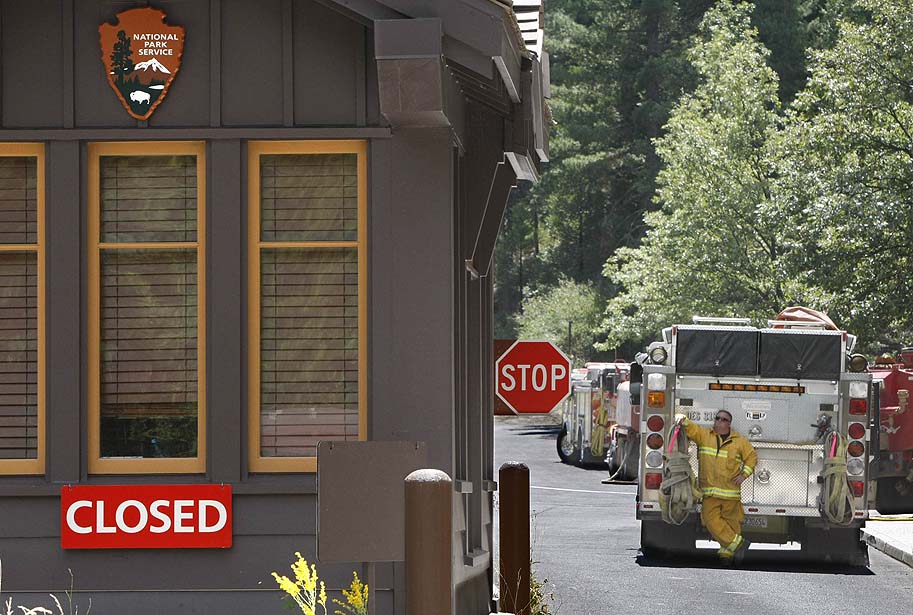
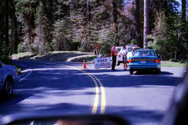
Highway 120 in both directions remains closed to all inbound and outbound Yosemite National Park traffic at Crane Flat, and on the east side at the Ten Lakes Trailhead. We anticipate the closure to last through Labor Day to allow fire crews to defend Tioga Road from the advancing fire. The fire is approximately 2 miles northwest of the Tioga Road and crews continue to prepare the road for fire suppression efforts.
On a positive note, fire crews are strategically positioned to defend the Hodgdon, Crane Flat, and White Wolf facilities.
There are two all-employee meetings scheduled for today, Thursday, August 29th to brief Yosemite National Park staff on the ongoing fire situation. There will be a meeting in the Yosemite Valley Auditorium at 10:00 am and another in the El Portal Large Breakroom at 2:00 pm. Representatives from the fire team, law enforcement, and the park's leadership will be on hand to brief staff and answer questions.
Again we want to thank all of the staff and fire crews working hard to protect the park and its natural and cultural treasures. Regional Director Chris Lehnertz, PWR Fire Management Officer Sid Beckman, and NPS Wildland Fire Officer Bill Kaage will be on site today to meet with staff and review overall fire operations. Director Jarvis will be on site late Friday and Saturday.
Don L. Neubacher, on behalf of the Executive Leadership Team (D. Neubacher)
Yesterday, firefighters prepared for firing operations to suppress growth south of Hetch Hetchy in Yosemite National Park. Crews will continue to construct and improve firelines and provide structure defense.
Highway 120 in both directions remains closed to all inbound and outbound Yosemite National Park traffic at Crane Flat, and on the east side at the Ten Lakes Trailhead. We anticipate the closure to last through Labor Day to allow fire crews to defend Tioga Road from the advancing fire. The fire is approximately 2 miles northwest of the Tioga Road and crews continue to prepare the road for fire suppression efforts.
On a positive note, fire crews are strategically positioned to defend the Hodgdon, Crane Flat, and White Wolf facilities.
There are two all-employee meetings scheduled for today, Thursday, August 29th to brief Yosemite National Park staff on the ongoing fire situation. There will be a meeting in the Yosemite Valley Auditorium at 10:00 am and another in the El Portal Large Breakroom at 2:00 pm. Representatives from the fire team, law enforcement, and the park's leadership will be on hand to brief staff and answer questions.
Again we want to thank all of the staff and fire crews working hard to protect the park and its natural and cultural treasures. Regional Director Chris Lehnertz, PWR Fire Management Officer Sid Beckman, and NPS Wildland Fire Officer Bill Kaage will be on site today to meet with staff and review overall fire operations. Director Jarvis will be on site late Friday and Saturday.
Don L. Neubacher, on behalf of the Executive Leadership Team (D. Neubacher)
Yosemite Largely Spared From Rim Fire
YOSEMITE NATIONAL PARK, CA (CNN) - The massive wildfire threatening Yosemite National Park continues to burn out of control. It is now the largest wildfire in the history of the Nevada range.
As many as 20 helicopters and air tankers are on hand, aiding the efforts of 3,800 firefighters. But as of now the fire is only 30 percent contained.
Although firefighters are gaining more ground on the Rim fire, there are places where it is still largely burning out of control.
"One of the biggest concerns is obviously you see these large trees out here so we have a lot of those trees that are dropping and falling in isolated areas so our firefighters really have to be heads up when they're out there putting water on the line," said Johnny Miller with Cal-Fire.
It's not just fire - the smoke is so thick in areas surrounding Yosemite that visibility is reduced to less than 100 yards.
The good news is that most of Yosemite National Park, famous for breathtaking scenery that attracted nearly 4 million visitors last year, remains mostly untouched by the fire.
"The park is safe. The park is a large park, it's 800,000 acres, so we're in about 24,000 acres of it burned so there is a large area of the park that is still accessible," Miller said.
What's not accessible by vehicle or on foot is much of the main portion of the fire, which has spread to 180,000 acres and is now the sixth-largest wildfire in California history. In those areas, firefighters are relying on aircraft dropping water and retardant to slow its spread.
Rim Fire Finally Slows in Encouraging Sign
By Mike Rosenberg
[email protected]
After the enormous Rim Fire ambushed the area in and around Yosemite National Park over the last week and a half, firefighters are finally starting to get a handle on the blaze and are eyeing full containment within two weeks.
The fire burned about 300 acres an hour on average during the 24-hour span ending Wednesday morning, down from 1,000 acres an hour the day before. It spread 10 times faster, burning more than 3,000 acres an hour, during its peak last week.
About 4,200 firefighters had the largest fire in the nation 23 percent contained, up from 20 percent a day before. Full containment is now expected by Sept. 10.
"A lot of that has to do with the fact that the weather is cooperating a lot more with us," said Cal Fire spokesman Daniel Berlant, noting temperatures have cooled and humidity has risen.
Berlant said the constant air drops and bulldozer-dug dirt lines around the perimeter of the fire have paid off.
"There's a lot of work that's been done over the past week and a half now to really put this fire to bed," Berlant said. "We are hoping that we've turned the corner."
Also on Wednesday, the California National Guard said it had launched an unmanned aircraft typically used in combat operations in Afghanistan and Iraq to fly over the fire. The drone isn't directly fighting the fire, but rather gathering information that firefighters on the ground can use to know where to go.
"It gives them a great amount of insight and information as far as understanding where the fire is most intense and how they can best approach it," said Capt. Will Martin of the California National Guard. "That's an advantage we don't have as far as being able to fly (human-operated aircraft) into the more dangerous areas of the fire."
The drone took off on Tuesday night from the March Air Reserve Base in Riverside, where it is being operated remotely. Although it has been used recently on other major wildfires, the domestic use for the MQ-1 "remotely-piloted aircraft" has been limited, and the National Guard is hoping to expand its role.
The fire had scorched 187,000 acres as of Wednesday morning, up from 184,000 a night before and 179,000 on Tuesday morning. It remained the seventh-largest wildfire in California recorded history, dating back 81 years.
The fire had spread into a small portion of Yosemite and reached the Hetch Hetchy watershed inside the park, the source of water for 2.6 million residents and businesses in the Bay Area, though water quality remains unaffected.
By Wednesday, the fire had stretched three-fourths of a mile past O'Shaughnessy Dam to the south and east, next to the Hetch Hetchy Reservoir where drinking water is stored. Firefighters are working to protect the infrastructure from the blaze as ash falls on the surface of the water.
Since the fire began on Aug. 17, small communities in Tuolumne County have been advised to evacuate, roads in and around the park have closed, a Berkeley-run Sierra family camp was destroyed, San Jose's family camp was damaged and giant sequoia trees have been threatened. Three firefighters have suffered minor injuries, 111 structures have been destroyed and the cost to fight the fire has hit $33 million. The cause of the Rim Fire remains under investigation.
Rim Fire Report from CBS KOVR - Sacramento
Virtual tour of the Rim Fire area
Rim Fire Causes Portion of Tioga Road in Yosemite National Park to be Temporarily Closed
Last Updated on Tuesday, 27 August 2013 15:21
Closure Needed to Support Firefighting Efforts in Park
A portion of the Tioga Road, from Crane Flat to White Wolf, will be temporarily closed to all vehicular traffic beginning tomorrow, Wednesday, August 28, 2013, at 12:00 noon. The closure is necessary for firefighters to perform fire suppression activities along the road. This portion of the road is anticipated to be closed at least through Labor Day Weekend. The park will issue an update as conditions allow for the reopening of the road.
“The work that will be performed over the next few days is instrumental in suppressing the Rim Fire within Yosemite. The safety of the firefighters working along the road is our paramount concern,” stated park Superintendent Don Neubacher.
Tamarack Flat and Yosemite Creek Campgrounds, both located along the Tioga Road within the closure, will remain closed during the fire suppression efforts. White Wolf Campground and White Wolf Lodge will remain closed. The Tioga Road will remain open east of White Wolf to the Tioga Pass Entrance. The Porcupine Flat Campground, the Tuolumne Meadows Campground, and all visitor services within Tuolumne Meadows will remain open.
Highway 41, from the southern portion of the park, and Highway 140, from the western portion of the park, will remain open. Both of these roads provide access to Yosemite Valley.
A fund to help the park restore trails, facilities, and wildlife habitat has been established by the Yosemite Conservancy. People wishing to contribute to the fund can donate online at yosemiteconservancy.org/fire. People can also donate via mail by sending donations to Yosemite Conservancy 101 Montgomery, Suite 1700 San Francisco, CA 95104.
For up-to-date Yosemite information regarding the Rim Fire, please visit the park’s website at: http://www.nps.gov/yose/planyourvisit/rimfire.htm.
Media Contacts:
Scott Gediman 209-372-0248
Kari Cobb 209-372-0529
Rim Fire destroys Berkeley's Toulumne Family Camp
Yosemite Fire Poses "Every challenge there can be"
Book/Bake/Craft Sale

The Wawona Friends of the Library annual fundraiser, Book/Bake/Craft Sale will be held Saturday, August 31 from 9 a.m. to 3 p.m. in the Library parking lot. If it rains, the sale moves to the Wawona Community Center.
Yosemite Takes Steps to Protect Sequoias From Fire
FRESNO, Calif. (KFSN) -- The Rim Fire is still threatening several communities in Yosemite National Park. Evacuation advisories have now been lifted for Buck Meadows and most of Pine Mountain Lake because crews have strengthened fire lines in the area.
Saturday the state secured federal financial assistance to help cover the cost of the firefight. The blaze has now grown to more than 129,000 acres and is seven percent contained.
Fire Chief Steve Henry from Coalinga is with a group providing structure protection in Tuolumne City. He says calmer weather conditions over the past 24 hours helped crews make some progress.
"They're putting in a lot more control lines, a lot more than they anticipated, so progress containment is growing rapidly," Henry said.
As a wildfire rages along the remote northwest edge of Yosemite National Park, officials cleared brush and set sprinklers to protect two groves of giant sequoias.
The iconic trees can resist fire, but dry conditions and heavy brush are forcing park officials to take extra precautions in the Tuolumne and Merced groves. About three dozen of the giant trees are affected.
"All of the plants and trees in Yosemite are important, but the giant sequoias are incredibly important both for what they are and as symbols of the National Park System," said spokesman Scott Gediman.
The trees grow naturally only on the western slopes of the Sierra Nevada and are among the largest and oldest living things on earth.
The Tuolumne and Merced groves in are in the north end of the park near Crane Flat. While the Rim Fire is still some distance away, park employees and trail crews are not taking any chances.
"We're not looking at them as any kind of immediate threat, but we're taking precautions," Gediman said.
More than 5,500 homes are threatened and four were destroyed. Voluntary and mandatory evacuations have been ordered.
The fire has been burning for a week. The cause is under investigation.
The fire held steady overnight at nearly 200 square miles along the park's northern border, but a spokesman for the California Department of Forestry and Fire Protection says firefighters didn't get their usual reprieve from cooler early morning temperatures Saturday.
"This morning we are starting to see fire activity pick up earlier than it has the last several days," said Cal Fire spokesman Daniel Berlant. "Typically, it doesn't really heat up until early afternoon. We could continue to see this fire burn very rapidly today."
The Rim Fire started in a remote canyon of the Stanislaus National Forest a week ago and is just 5 percent contained.
The fire has grown so large and is burning dry timber and brush with such ferocity that it has created its own weather pattern, making it difficult to predict in which direction it will move.
"As the smoke column builds up it breaks down and collapses inside of itself, sending downdrafts and gusts that can go in any direction," Berlant said. "There's a lot of potential for this one to continue to grow."
The tourist mecca of Yosemite Valley, the part of the park known around the world for such sights as the Half Dome and El Capitan rock formations and waterfalls, remained open, clear of smoke and free from other signs of the fire that remained about 20 miles away.
More than 2,600 firefighters and a half dozen aircraft are battling the blaze.
The fire is burning toward the Hetch Hetchy reservoir, where San Francisco gets 85 percent of its water and power for municipal buildings, the international airport and San Francisco General Hospital. Gov. Jerry Brown declared a state of emergency because of the threats.
Officials with the San Francisco Public Utilities Commission are running continuous tests on water quality in the reservoir that is the source of the city's famously pure water.
Deputy General Manager Michael Carlin told The Associated Press on Saturday that no problems from falling ash have been detected.
"We've had other fires in the watershed and have procedures in place," he said.
The commission also shut two hydro-electric stations fed by water from the reservoir and cut power to more than 12 miles of lines. The city has been buying power on the open market.
A four-mile stretch of State Route 120, one of three entrances into Yosemite on the west side remains closed. Two other western routes and an eastern route were open.
The Associated Press contributed to this report.
Town Hall Meetings September 4 & 5, 2013
You're invited Yosemite/Mariposa County Tourism Bureau
Town Hall Meetings September 4 & 5, 2013 The Yosemite Mariposa County Tourism Bureau has scheduled the following Town Hall Meetings for September. There will be 3 meetings held in different areas of the county. Each meeting will focus on:
Looking forward to seeing you there! Julie Hadzega Marketing Coordinator Yosemite/Mariposa County Tourism Bureau P.O. Box 967 5320 State Highway 49 North, Suite 4 Mariposa, CA 95338 Office: (209) 742-4567 Cell: (2o9) 628-5088 Fax: (209) 742-5176
Town Hall Meetings September 4 & 5, 2013 The Yosemite Mariposa County Tourism Bureau has scheduled the following Town Hall Meetings for September. There will be 3 meetings held in different areas of the county. Each meeting will focus on:
- The Tourism Bureau Annual Report for 2012 - 2013
- Advertising/Marketing Campaigns for the off-season
- How working with a Travel Agency can grow your business
- YosemiteExperience.com
- Proposed County TOT increase
- Booking Engine
Looking forward to seeing you there! Julie Hadzega Marketing Coordinator Yosemite/Mariposa County Tourism Bureau P.O. Box 967 5320 State Highway 49 North, Suite 4 Mariposa, CA 95338 Office: (209) 742-4567 Cell: (2o9) 628-5088 Fax: (209) 742-5176
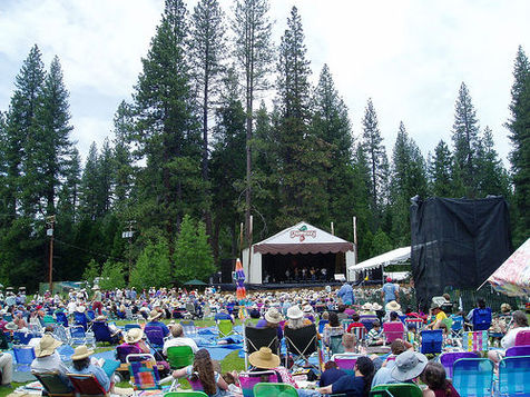
Fire threat cancels Strawberry Music Festival near Yosemite
By Bee Staff Reports
Tuolumne County — For the first time in its 32-year history, the Strawberry Music Festival will not take place on Labor Day weekend at Camp Mather near Yosemite National Park.
The roots music festival posted on its Facebook page Thursday afternoon the following announcement from the Tuolumne County Community Resources Agency and the Tuolumne County Board of Supervisors:
"Due to the ongoing State of Emergency and the potential adverse effects of the wildfire on public health, safety and welfare, the County of Tuolumne cannot allow the Strawberry Music Festival to occur at the site as originally permitted on the dates of August 29 through September 2, 2013."
Cecily Johnson-Underwood, a spokeswoman for the festival, said she could not comment further on whether the festival would be postponed or moved. "We've had zero time to make any calls," she said.
The Rim fire, which broke out in a remote area near Groveland on Saturday, has consumed nearly 54,000 acres in Tuolumne and Mariposa counties and is threatening 2,500 structures. Firefighters have struggled to protect small communities and campgrounds in the area, but nine structures have been destroyed.
The Tuolumne County Board of Supervisors held an emergency meeting Wednesday afternoon saying in a resolution that the fire is "now directly threatening various communities and businesses within the County and is beyond our capabilities." Gov. Jerry Brown has declared a state of emergency.
The Strawberry Music Festival was expected to attract more than 4,000 tickets. Headliners this year included the Mavericks, Patty Griffin and Oakdale's Good Luck Thrift Store Outfit. Many audience members camp and participate in jam sessions throughout the weekend.
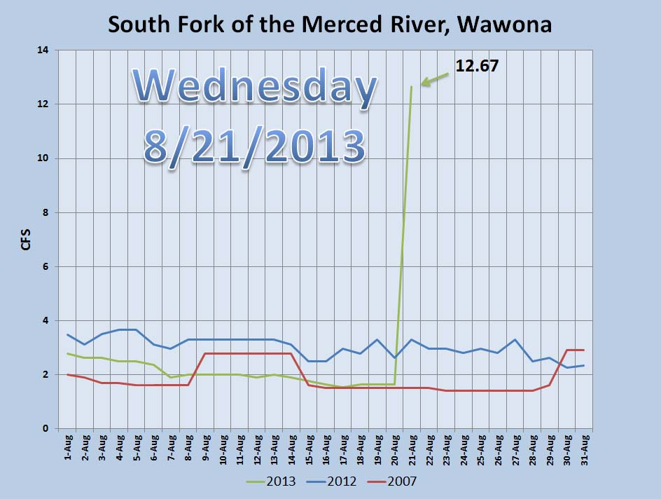
A little Rain Helps River Level a Lot
Over 10,000 Acres Burned in Rim Fire
Acres Burned: 10,170 Structures Threatened: 2,500
Containment: 0% Structures Destroyed: 7
Fire Start Date: August 17, 2013 Injuries: 0
Fire Cause: Under Investigation Total Personnel: 455
Cost to date: $800,000
Summary
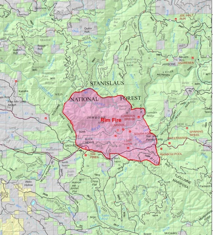
*The Rim Fire is located within the Stanislaus National Forest on the Groveland Ranger District. The fire is currently burning west of Lumsden Bridge in the Tuolumne River Canyon, north of the Clavey River, east of the Clavey and Tuolumne River, and south of Highway 120 beyond Rainbow Pool. The South Central Sierra Interagency Incident Management Team is in command of the Rim Fire.
Fire Update
*Firefighter and public safety remains the highest priority.
*The Rim Fire burned two residences and five outbuildings along Packard Canyon Road yesterday as the fire pushed eastward. Structures remain threatened and structure defense is in progress. The fire continues to burn both sides of the Jawbone Ridge and cross the Tuolumne River below the Groveland Ranger Station and the community of Buck Meadows. There are a few areas the fire encroached and crossed Highway 120.
Road Closures
Highway 120 at Smith Station, Cherry Lake at Highway 120, and Highway 120 remains closed to all outbound traffic from Yosemite National Park.
Evacuations
Highway 120 at Cherry Lake Road west to Smith Station has been evacuated. An evacuation center is open at the Tioga High School at 19304 Ferretti Road in Groveland, California.
For more information on this press release or if you have questions regarding the information, please contact the Rim Fire at 805-727-4775
Updated information can also be obtained at http://www.inciweb.org/incident/3660/
Rim Fire Evacuations Enforced in the Buck Meadows Area of Mariposa County
Last Updated on Monday, 19 August 2013 15:12
August 19, 2013 - Reportedly the Rim Fire has jumped the Tuolumne River and Rim Fire IC is requesting that Fire Evacuations be enforced in the Buck Meadows area, of Mariposa County. A Sheriff’s Code Red Evacuation Order message is being sent to Buck Meadows. Sheriff resources are in the Buck Meadows making notifications currently.
Rim Fire Road Closures Announced Last Updated on Monday, 19 August 2013 15:29 Rim Fire Road Closures Announced
Closures: HWY 120 closed 4 miles west of Groveland Ranger District and 4 miles east of Buck Meadows.
Rim Fire in Stanislaus National Forest Monday, August 19, 2013

Click for larger image
The Rim Fire is burning up a north facing slope to the south of the Clavey River towards Jawbone Ridge on the Groveland Ranger District of the Stanislaus National Forest. Firefighting aircraft are on scene with ground units en route to the very isolated and steep Clavey River Canyon area about one and a half miles east of the confluence with the Tuolumne River.
River Level Still Dropping in Wawona
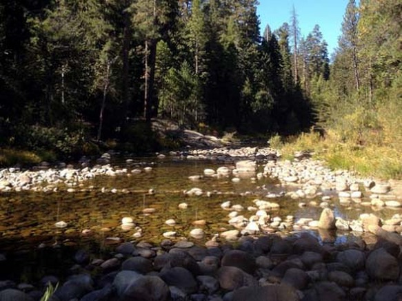
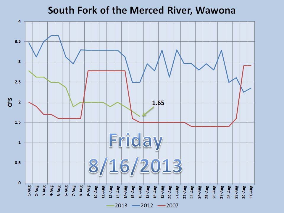
Aspen Fire in the Sierra National Forest Clean Up Operations Continue
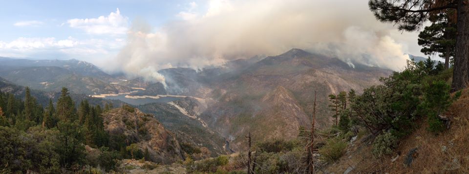
Last Updated on Thursday, 15 August 2013 19:38 August 14, 2013 - Clovis, CA –
The Aspen Fire continues to impact the Kaiser Wilderness Area and surrounding lands in the Sierra National Forest. Although the smoke has cleared and many fire fighters have moved on to other fires, crews continue to work on mop up and rehabilitation of fire lines.
Crews are making good progress, and forest managers plan to reopen some closed areas this weekend. Stump Springs Road and Sample Meadow Campground are expected to open August
17. West Kaiser Campground remains closed. Trails within the eastern side of Kaiser Wilderness Area, open Saturday, including: Sample Meadow, Potter Pass Cutoff, and Badger Trail. All other trails within the Wilderness area remain closed.
Clean up and rehabilitation of fire lines promote rapid restoration of areas impacted by fire. Repair crews build water bars across fire lines, break up brush piles created by dozers, and cover exposed bare ground with natural mulch which prevents erosion and speeds recovery and naturalization of fire lines. Crews are also grading impacted dirt roads and ensuring that no trash or equipment is left behind.
Fire managers report that the fire did a good job of clearing underbrush and reducing fuel buildups. Fire is a natural part of the High Sierra ecosystem, and scientists expect the burned areas to recover quickly.
Campers and hunters are encouraged to stay safe while visiting the area by respecting the closures and watching for heavy equipment that may be traveling or working in the area.
For additional information call the Sierra National Forest, High Sierra Ranger District Office: (559) 855-5355.
End of Season Naturalist BBQ
A hungry crowd joined Burrel “Buckshot” Maier at the annual END OF SEASON NATURALIST BBQ at the corral of the Wawona Gray Barn on August 7. Burrel’s BBQ tri tip and potluck by the guests proved to be another successful event. No one went away hungry! Thanks to the chefs and the volunteers who made the evening possible.
