WawonaNews.com - August 2018
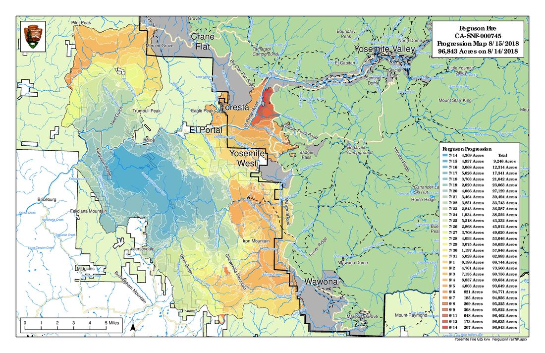
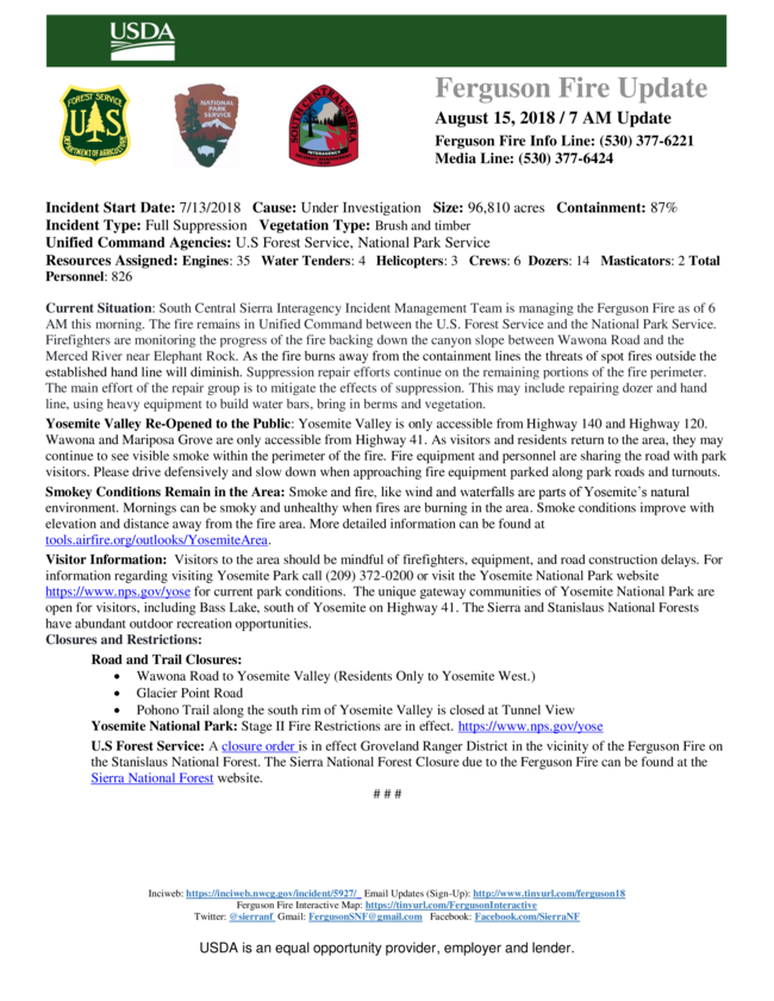
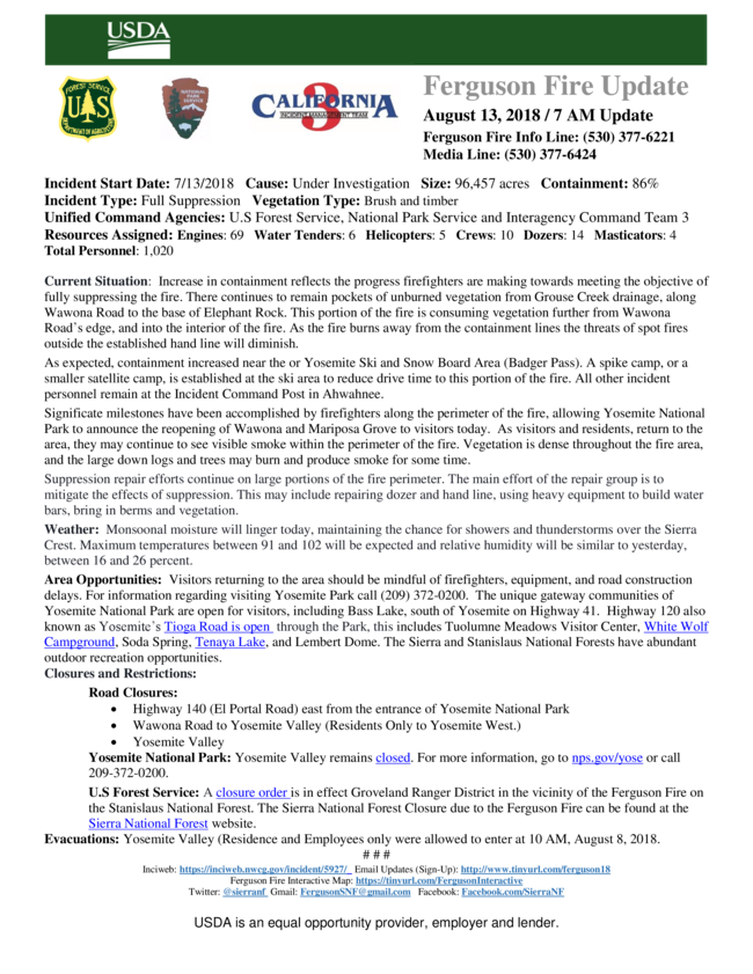
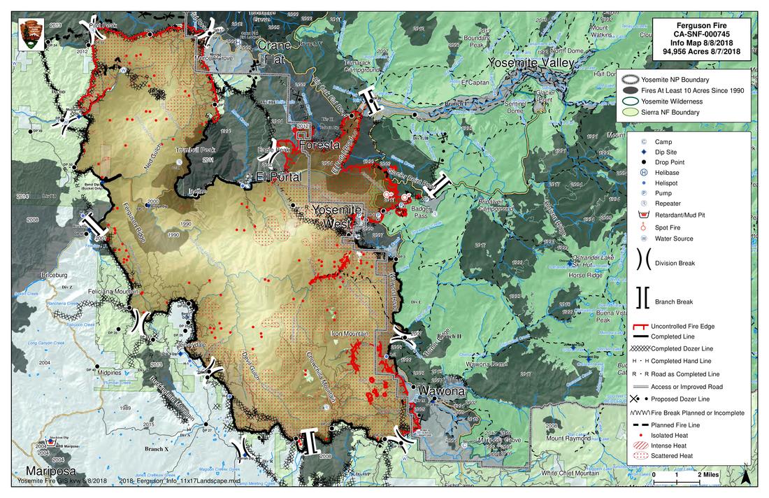
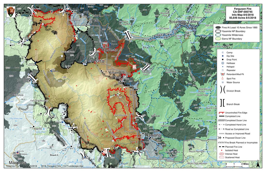
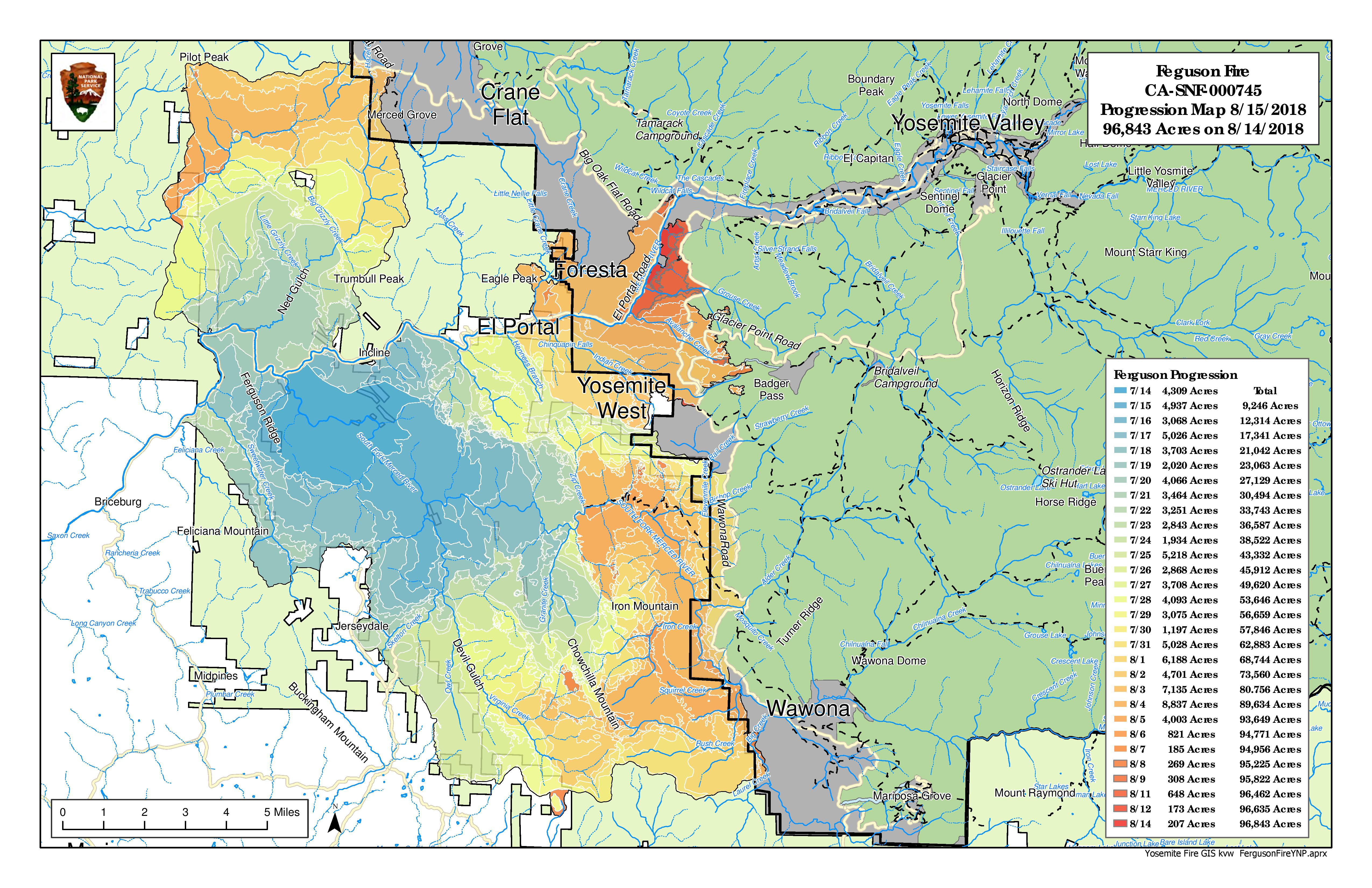
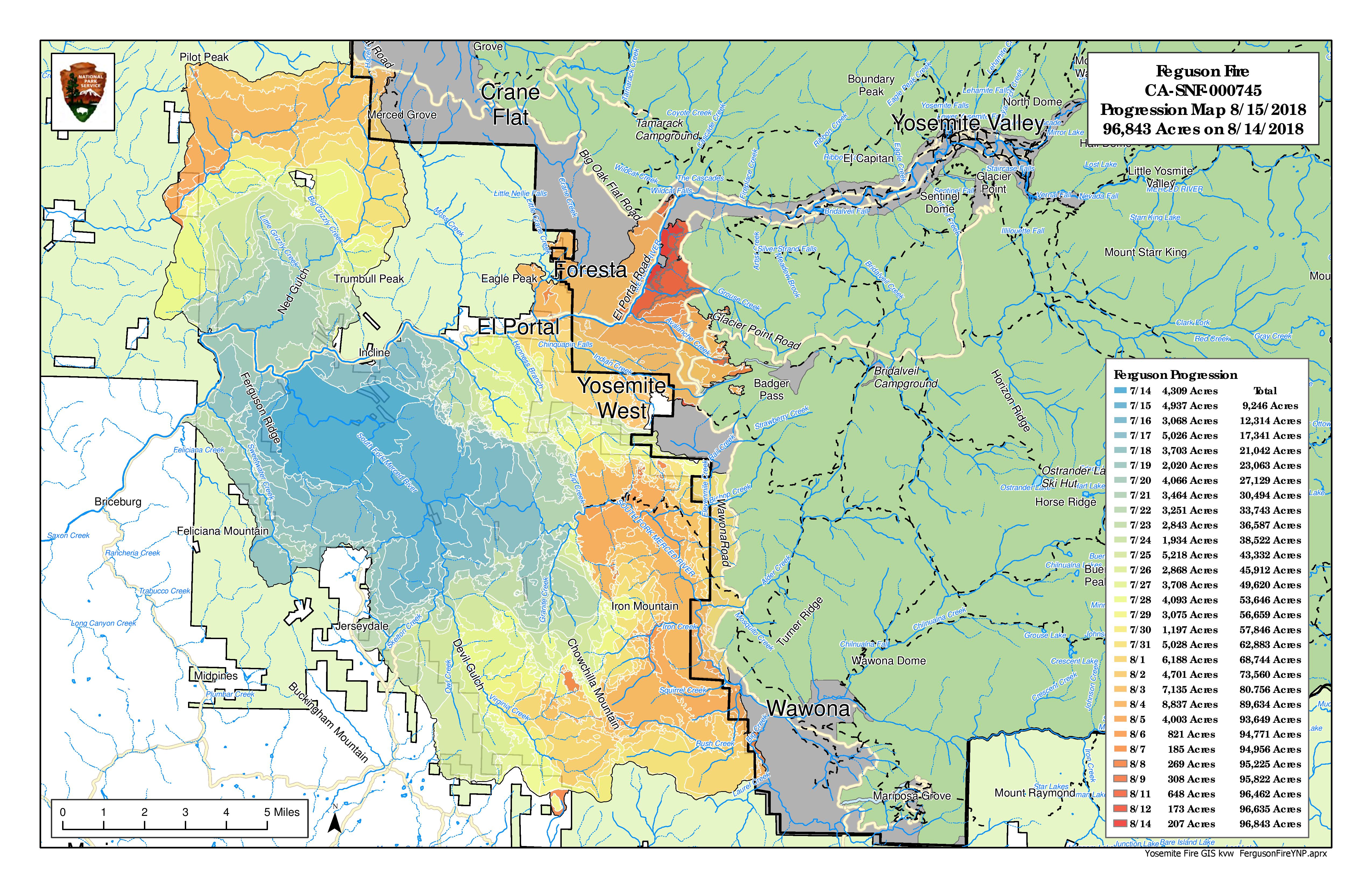
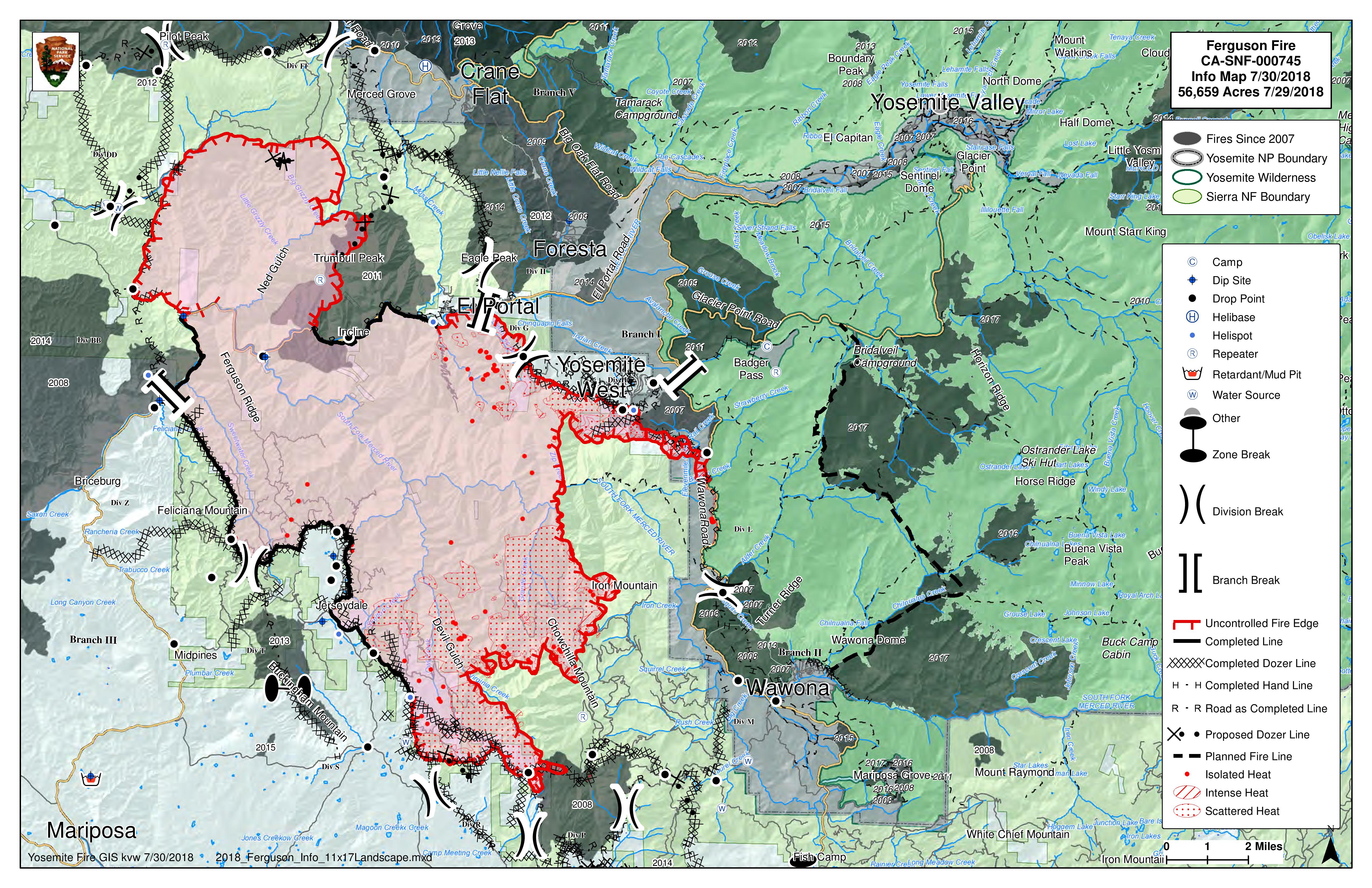
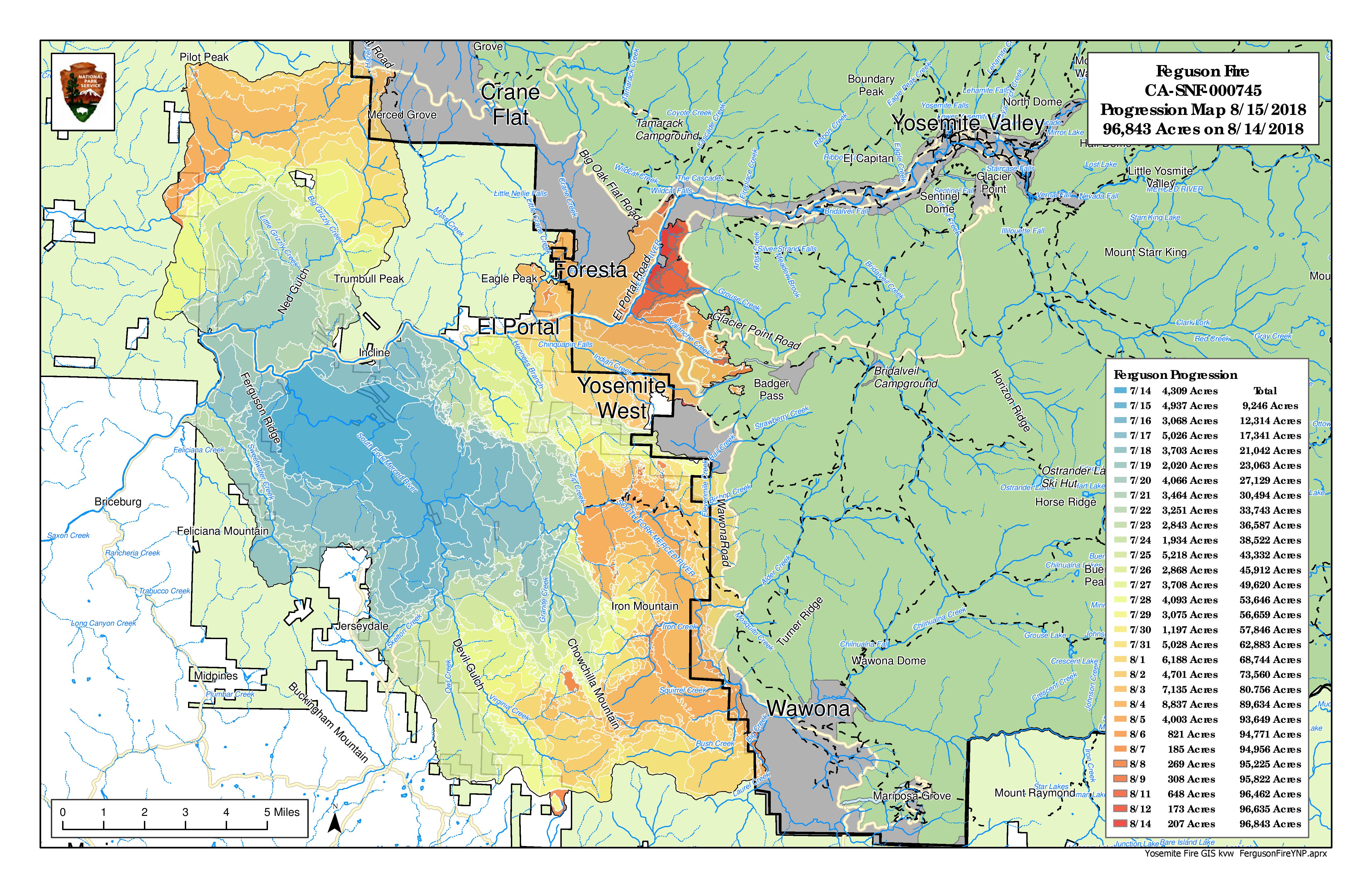
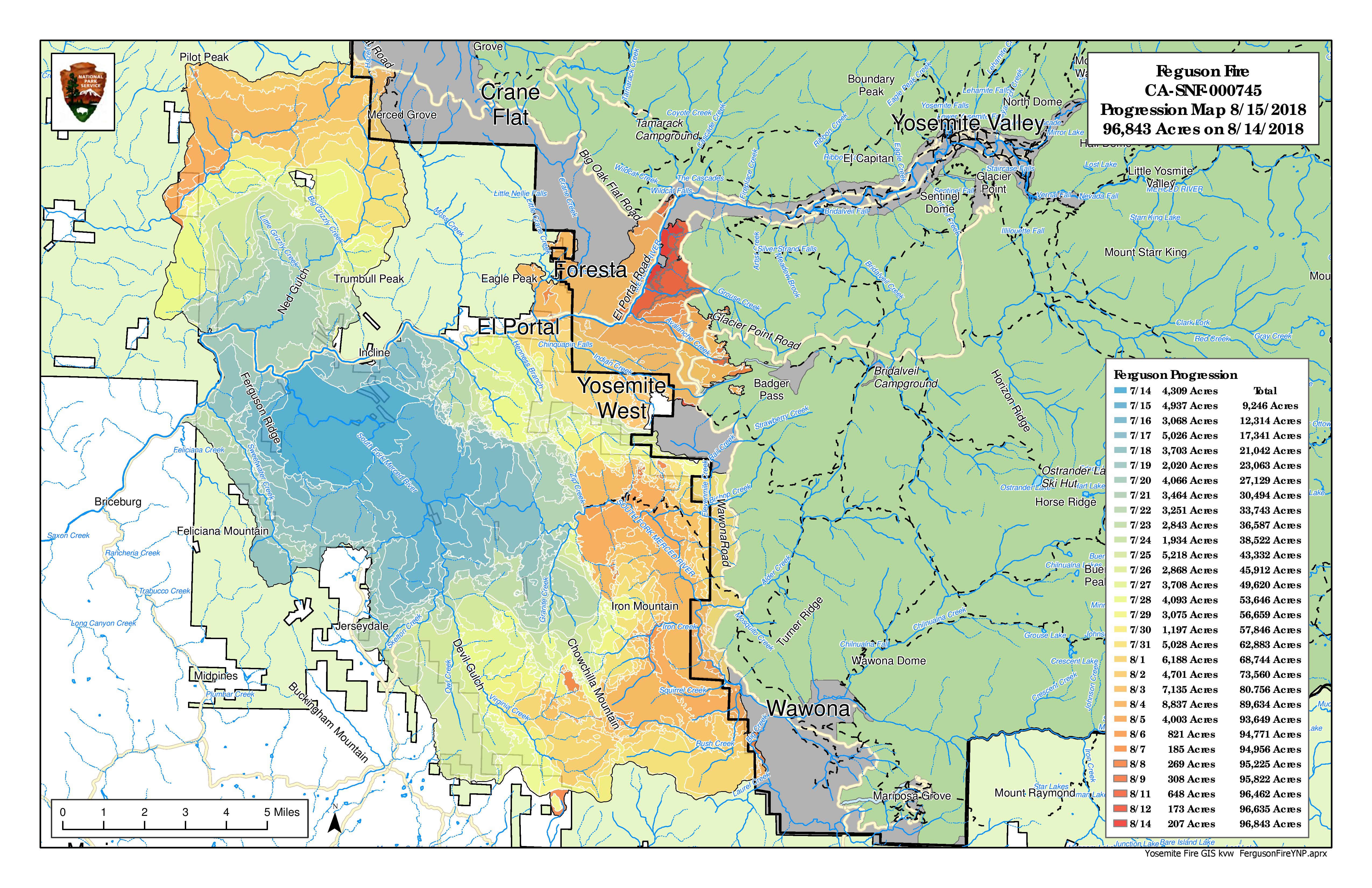
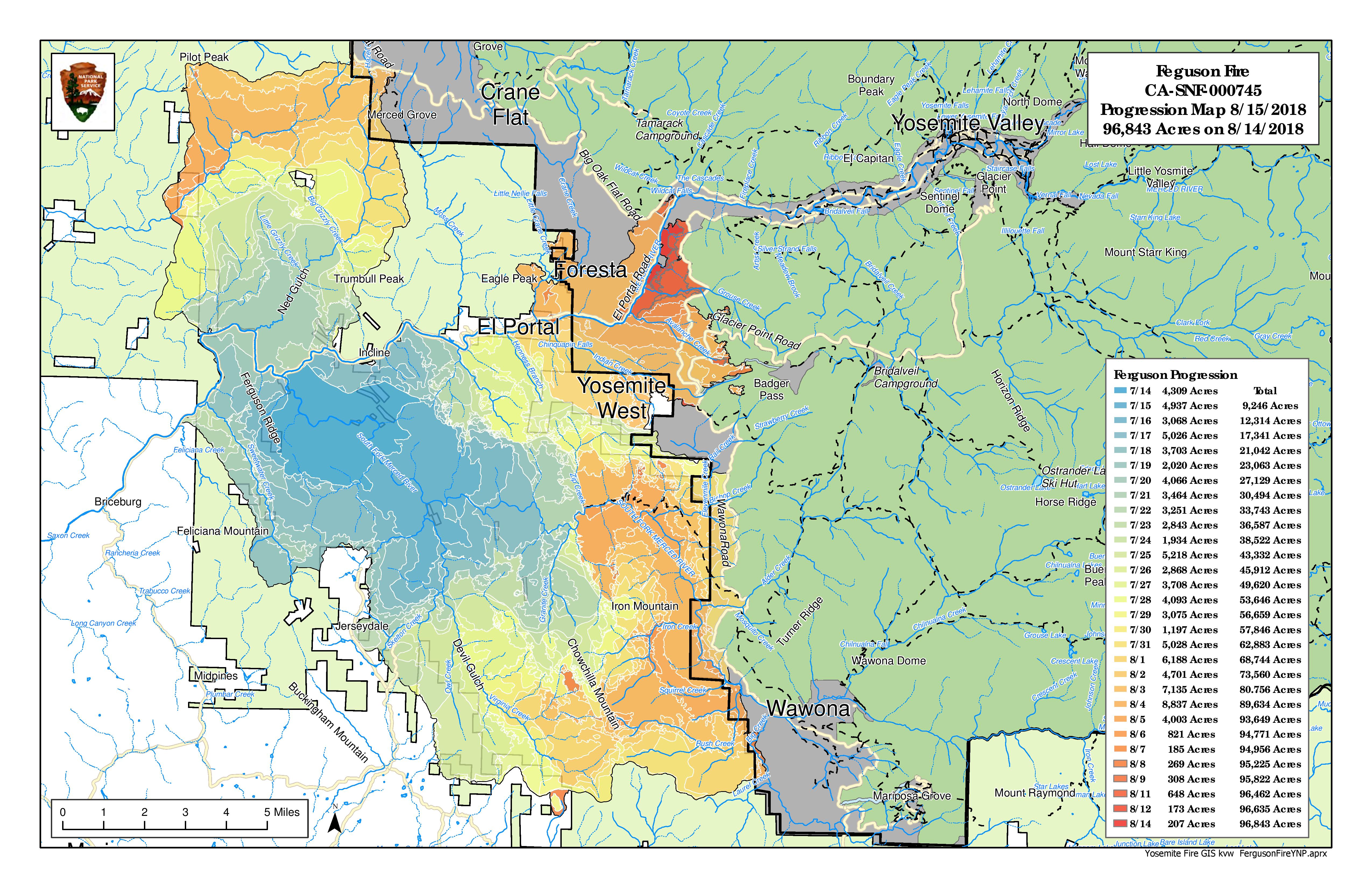
Ferguson Fire Perimeter Map - August 15
Yosemite National Park Enters Stage 2 Fire Restrictions
Tuesday, August 14th, 2018
Yosemite National Park is experiencing extreme fire danger along with continued hot and dry weather patterns. Due to the current and predicted fire conditions and fire behavior the Superintendent of Yosemite National Park is implementing Stage 2 Fire Restrictions until further notice is given.
By order of the Superintendent of Yosemite National Park and under authority of Title 36, Code of Federal Regulations, Sections 1.5(a), 1.5(a)(1) and 2.13(c):
There are no administrative exemptions to this order. Notice of closure will be posted and areas will be monitored to ensure compliance. This designation will remain in place until rescinded.
For information planning your visit in Yosemite National Park visit : www.nps.gov/yose
-NPS-
Yosemite National Park is experiencing extreme fire danger along with continued hot and dry weather patterns. Due to the current and predicted fire conditions and fire behavior the Superintendent of Yosemite National Park is implementing Stage 2 Fire Restrictions until further notice is given.
By order of the Superintendent of Yosemite National Park and under authority of Title 36, Code of Federal Regulations, Sections 1.5(a), 1.5(a)(1) and 2.13(c):
- The building, maintaining or attending of a wood or charcoal fire (including wood burning stoves) is prohibited within the Yosemite Wilderness, including at the High Sierra Camps, at all elevations.
- Portable stoves using pressurized gas, liquid fuel or propane are permitted as are alcohol stoves (with and without a shutoff valve) including alcohol tablet/cube stoves.
- Smoking is prohibited except within an enclosed vehicle, a building in which smoking is allowed, designated campgrounds, designated picnic areas, paved developed areas or designated smoking areas.
- Campfires and cooking fires may still be used in designated campgrounds, designated picnic areas, commercial lodging and residential areas in developed portions of the park in accordance with park regulations.
There are no administrative exemptions to this order. Notice of closure will be posted and areas will be monitored to ensure compliance. This designation will remain in place until rescinded.
For information planning your visit in Yosemite National Park visit : www.nps.gov/yose
-NPS-
Free N95 Respirator Masks available at The Pine Tree Market

August 14, 2018 - Mariposa County, in cooperation with Cal OSHA, is distributing N95 Respirator Masks to community members due to the unhealthy air quality associated with California wildfires. When air quality is unhealthy, staying indoors in clean air spaces and minimizing outdoor activity is recommended, especially for children, the elderly, and individuals with certain medical conditions.
If you must be outside for an extended period, N95 masks may help to keep bad air out if worn properly. People with underlying medical conditions (such as heart and lung disease) are advised to check with your medical provider to determine whether an N95 respirator mask may be right for you. Free N95 respirator masks are being made available beginning August 10, at The Pine Tree Market.
If you must be outside for an extended period, N95 masks may help to keep bad air out if worn properly. People with underlying medical conditions (such as heart and lung disease) are advised to check with your medical provider to determine whether an N95 respirator mask may be right for you. Free N95 respirator masks are being made available beginning August 10, at The Pine Tree Market.
Yosemite Valley Reopens Today, August 14
Search For Lost Hiker In Matterhorn Canyon Area

Posted by: Kellie Flanagan August 13, 2018 - 2:01 pm
YOSEMITE — Authorities with the National Park Service are searching for a missing man who was last seen near Yosemite National Park.
Scott Tenczar was at the Bridgeport Ranger Station on Wednesday, July 25. Tenczar, 48, is described as an experienced hiker who knows the area well. Yosemite National Park reports say he planned to backpack from Robinson Creek to Crown Lake, Matterhorn Canyon, Smedberg Lake, Seavey Pass, and Peeler Lake.
Scott Tenczar has brown hair and hazel eyes, is 6-feet, 1-inch tall, and weighs about 185 pounds. Yosemite authorities say he uses and wears mostly army-colored items, including the colors olive-drab green, tan, and camouflage. He also carries fishing gear.
Anyone who was in the area of Robinson Creek, Crown Lake, Matterhorn Canyon, Smedberg Lake, Seavey Pass, or Peeler Lake between July 25 and August 5, 2018, is encouraged to please contact the National Park Service Investigative Services Branch at (888) 653-0009 or online. People who were in the area are asked to contact the investigator, even if you don’t believe you have any information about the missing person.
Live Wawona Smoke Cam
Yosemite Roads: What's Open and What's Closed
August 11 - Wawona and Mariposa Grove will open to the public on Monday, with access available only via South Entrance. Yosemite Valley opens on Tuesday, with access only via Highways 140 and 120. The road between Wawona and Yosemite Valley, as well as Glacier Point Road, will remain closed.
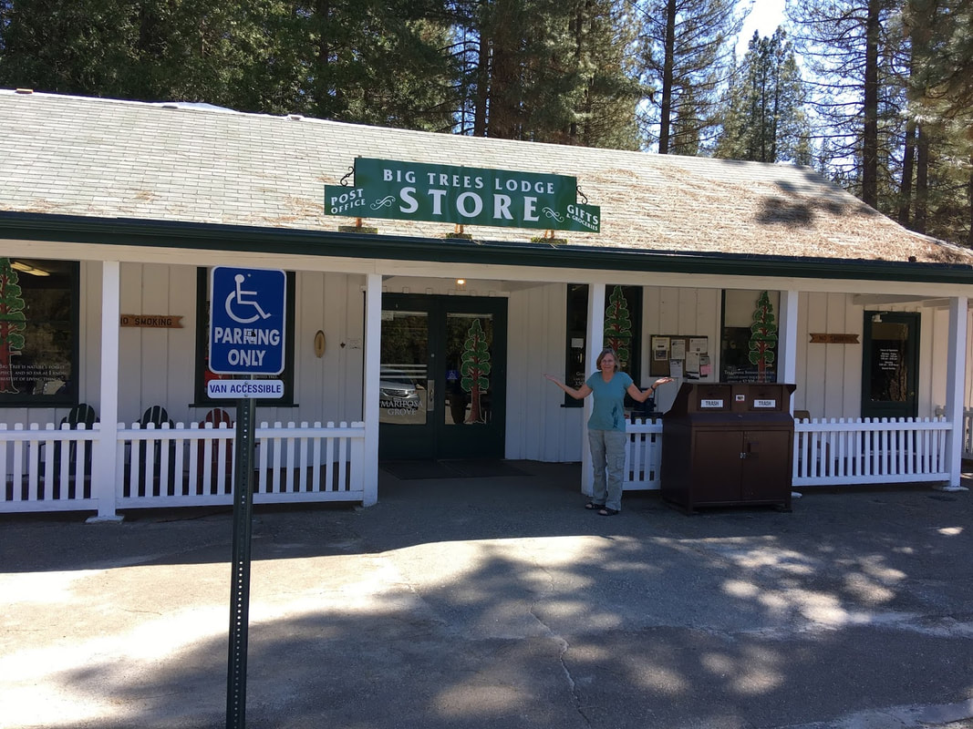
Big Trees Lodge Store to Reopen Monday, August 13
Operations for the Yosemite Hospitality will remain closed until August 30th. The general store and post office will open on Monday, August 13th from 9 AM to 6 PM. Once the Hotel reopens the store operating will go back to normal operating hours from 8 am -8 PM (7PM after Labor Day). The stables are closed for the season. The golf course at this time is TBA.
Best,
Amanda Lee
Big Trees Lodge
Best,
Amanda Lee
Big Trees Lodge
One-Way Traffic Control On Highway 41 North Of Oakhurst
Posted by: Kellie Flanagan August 10, 2018 - 5:39 pm
FISH CAMP — Caltrans, in cooperation with Robert J. Frank Construction, announces one-way traffic control on State Route 41 near the community of Fish Camp in Mariposa County over the next three weeks, as crews install a cement barrier in the center-divide intended to increase safety throughout the corridor.
The following one-way traffic control will take place:
Traffic delays could last up to 10 minutes at a time during operations.
Closures may continue for longer periods of time each day if necessary, due to delays caused by weather or uncontrollable events that may occur during construction.
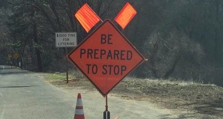
Construction crews will be conducting one-way traffic control during this time with the use of flagging personnel through the work zone. Commuters are reminded to obey flagging personnel and pay close attention to construction vehicles and personnel.
FISH CAMP — Caltrans, in cooperation with Robert J. Frank Construction, announces one-way traffic control on State Route 41 near the community of Fish Camp in Mariposa County over the next three weeks, as crews install a cement barrier in the center-divide intended to increase safety throughout the corridor.
The following one-way traffic control will take place:
- Beginning Monday, Aug. 13, through Friday, Aug. 31, one-way traffic control will be in effect on State Route 41 near Summerdale Campground in Mariposa County.
- One-way traffic control will be in effect Monday through Friday from 6 a.m. until 6 p.m. daily.
Traffic delays could last up to 10 minutes at a time during operations.
Closures may continue for longer periods of time each day if necessary, due to delays caused by weather or uncontrollable events that may occur during construction.
Construction crews will be conducting one-way traffic control during this time with the use of flagging personnel through the work zone. Commuters are reminded to obey flagging personnel and pay close attention to construction vehicles and personnel.
Mariposa Grove of Giant Sequoias to Open Monday, Aug.13, Vacation Rentals to Resume Same Day
Yosemite Valley To Reopen The Following Day
Official Park update:
Yosemite National Park is pleased to announce that Yosemite Valley will reopen to visitors on Tuesday, August 14th, at 9:00 a.m. Yosemite Valley has been closed to visitors since Wednesday, July 25th, due to impacts from the Ferguson Fire. Visitors can access Yosemite Valley from the El Portal Road (Highway 140), the Big Oak Flat Road (Highway 120), or the Tioga Road (Highway 120).
The Wawona Road (Highway 41) will remain closed from Wawona to Yosemite Valley for at least another week due to ongoing fire activity and firefighter operations. Park visitors should be aware that there is still active fire and smoke on the roads and people should drive with extreme caution. Delays on the roads are possible due to fire activity and ongoing firefighter operations. There will be limited hours and limited visitor services at park facilities as the park returns to normal operations.
The Mariposa Grove of Giant Sequoias will reopen to the public on Monday, August 13th, at 9:00 a.m. Visitors can access the Mariposa Grove via the South Entrance (Highway 41) and park in the newly constructed parking area. The free shuttle buses to the Mariposa Grove will begin at 9:00 am. and take visitors to the newly restored Mariposa Grove of Giant Sequoias. The Mariposa Grove reopened to visitors on June 14th, after a 3 year restoration project conducted in partnership with Yosemite Conservancy. Visitors will be able to travel to the Wawona area via the South Entrance (Highway 41). However, there is no access to Yosemite Valley via Highway 41.
The Glacier Point Road remains closed and is expected to open when the Wawona Road (Highway 41) reopens. The Hetch Hetchy Area remains closed due to smoke impacts but is expected to reopen soon.
"We'd like to express our sincere gratitude to the firefighters and, Incident command teams for their great efforts in suppressing the Ferguson Fire. We'd also like to express our gratitude and thanks to our gateway communities who tirelessly helped visitors to the area while they were being impacted by the fire", stated Michael Reynolds, Yosemite National Park Superintendent. "This is truly a historic and unprecedented event in park history, and we are thrilled to welcome back visitors to Yosemite Valley and the Mariposa Grove."
New Wawona Property For Sale
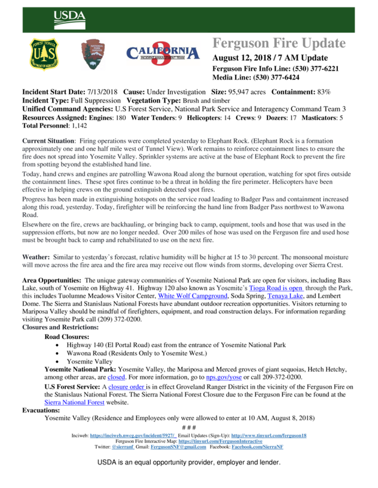
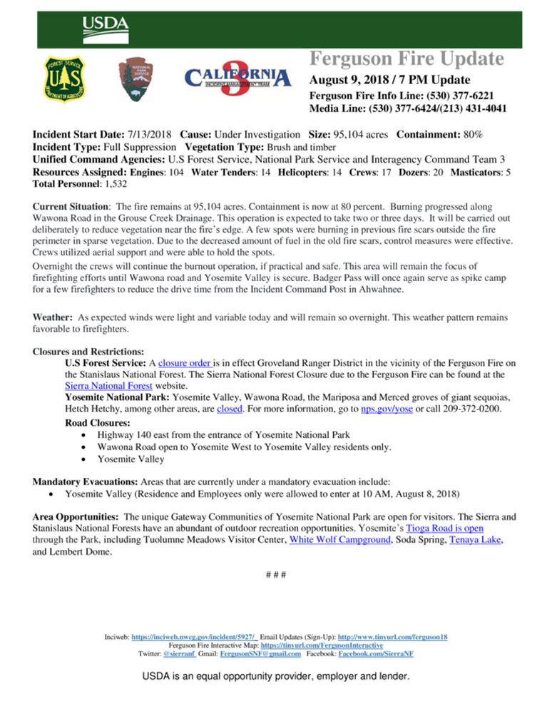
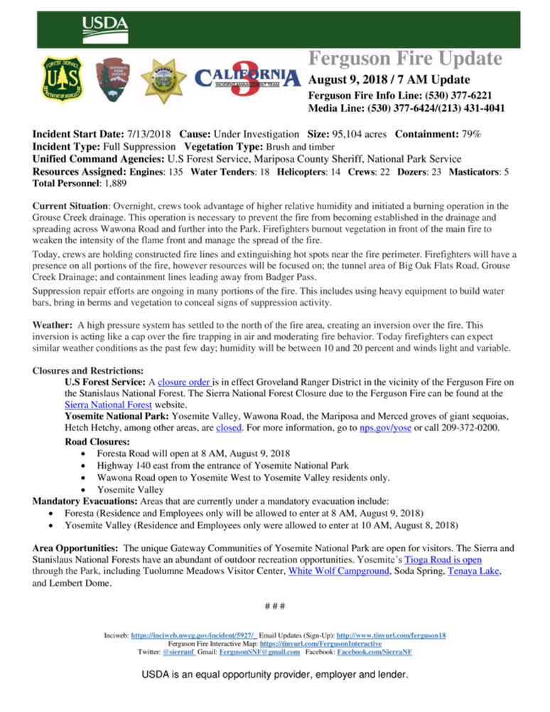
Ferguson Fire 80% Contained - August 9
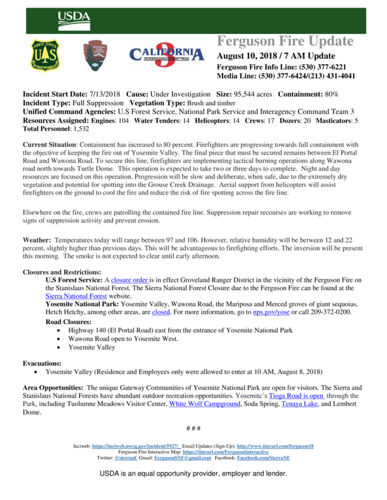
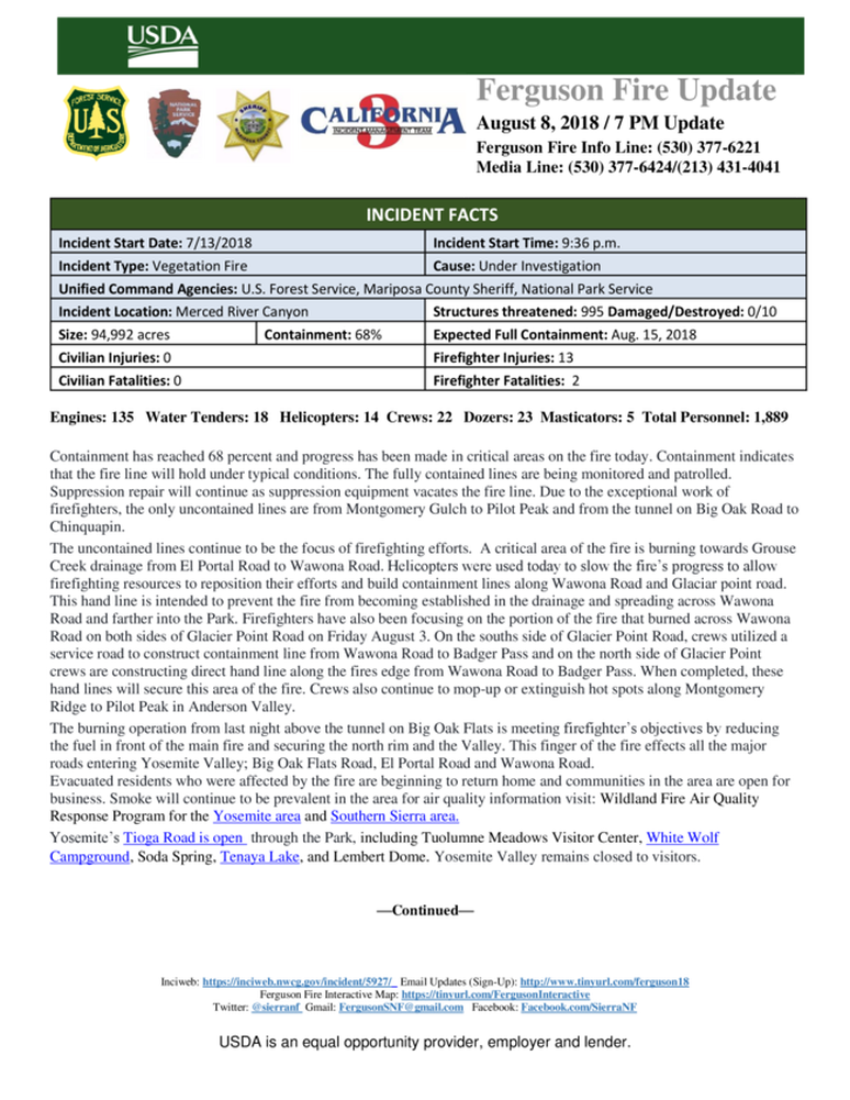
Ferguson Fire 68% Contained
Letter From Firefighters to Wawona
This is a thank-you note left at the front door of the Heringer house in Wawona from Maeve Juarez, Montecito (Santa Barbara), CA, Fire Department, who was the Wawona Structures Fire Supervisor for our recent and on-going Ferguson Fire that threatened the Wawona community and is still burning in portions of Yosemite National Park. She thanks Wawona for our generosity and support of the fire Strike Teams.
Besides the support and many “thank-yous” from Wawona residents, WAPPOA allocated $1000.00 in funds split between the two Wawona markets to provide complimentary food, snacks, beverages and sundries to firefighters in the area – this was very well received by the firefighters, EMTs, and Strike Teams!
With containment of the Wawona portion of the fire, Maeve and many of the Teams have been re-assigned elsewhere in California or moved to more active portions of the Ferguson Fire.
THANK-YOU FIREFIGHTERS, EMTS AND STRIKE TEAMS for saving our community!!!!!
Wayne Heringer
Wawona
Maeve Juarez
In case you would like to know more about Maeve Juarez, who was responsible for the noble gesture mentioned in the space above, we have posted this video about her heroics during the Montecito mud slides earlier this year.
The Latest From Wawona- August 8
Gary Wuchner, Aug. 8, Wawona -
I’m writing this from Wawona..best air in weeks.
Many are asking about security in residential area. At the South Entrance LEs are checking every vehicle to be sure folks are residents or have business in Wawona. YW and the Valley are being re-populated so an emphasis is on IDs or vehicle stickers.
Wawona air is the clearest since the beginning of the fire. Although visibility north of Wawona remains pretty poor.
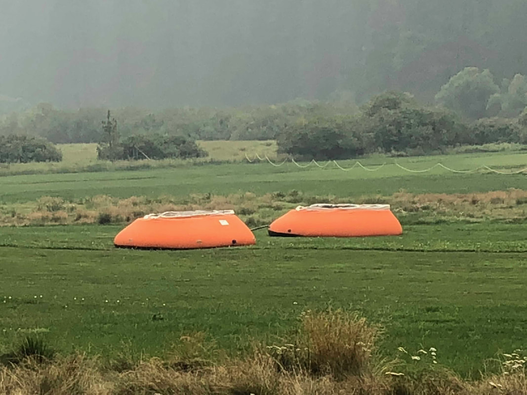
Fire crews continue w/ heavy mop-up and being supported by a fleet of water tenders west and along Wawona Rd north.
Residents will need to do a lot of blow down, sweeping etc., due to ash fall. Electrical power at my residence was not turned off, and no spoiled food issues.
Ferguson Fire winding down, some evacuation orders lifted
Wawona's Elise Bevington Interviewed By ABC30
The Latest From Wawona
Aug. 7, 10:45 AM, by Gary Wuchner - Residents who visited their homes after the evacuation restrictions were lifted yesterday, reported the air quality was so impaired they returned to the Tenaya Lodge. Air quality will improve through the week with continued mop-up operations continue near Wawona.
Fire crews continue to be assigned to Wawona and will be mopping-up direct to the constructed fire line west of Wawona. Fire managers want that fire line "cold" to prevent re-heating/re-kindling, eliminating further threats to the community. Pockets of unburned fuel within the South Fork of Merced River will continue to produce smoke.
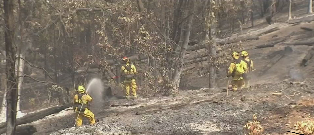
Smoldering may continue for many days. Mop-up operations consist of fire crews hiking from the edge of the fire line and putting out all smoldering logs, stumps, and areas of heat. It is slow, hot, dirty and no less dangerous work. A key hazard are deep ash pits. Crews will build depth into this cold trailing operation of 150 feet or more into the interior, off the fire perimeter edge, to attain full containment and control.
Nice work by the Team and crews assigned to the Wawona area keeping the fire out of Wawona without injuries and property loss or damage. Thank you.
Hwy. 120 To Reopen Today at Noon
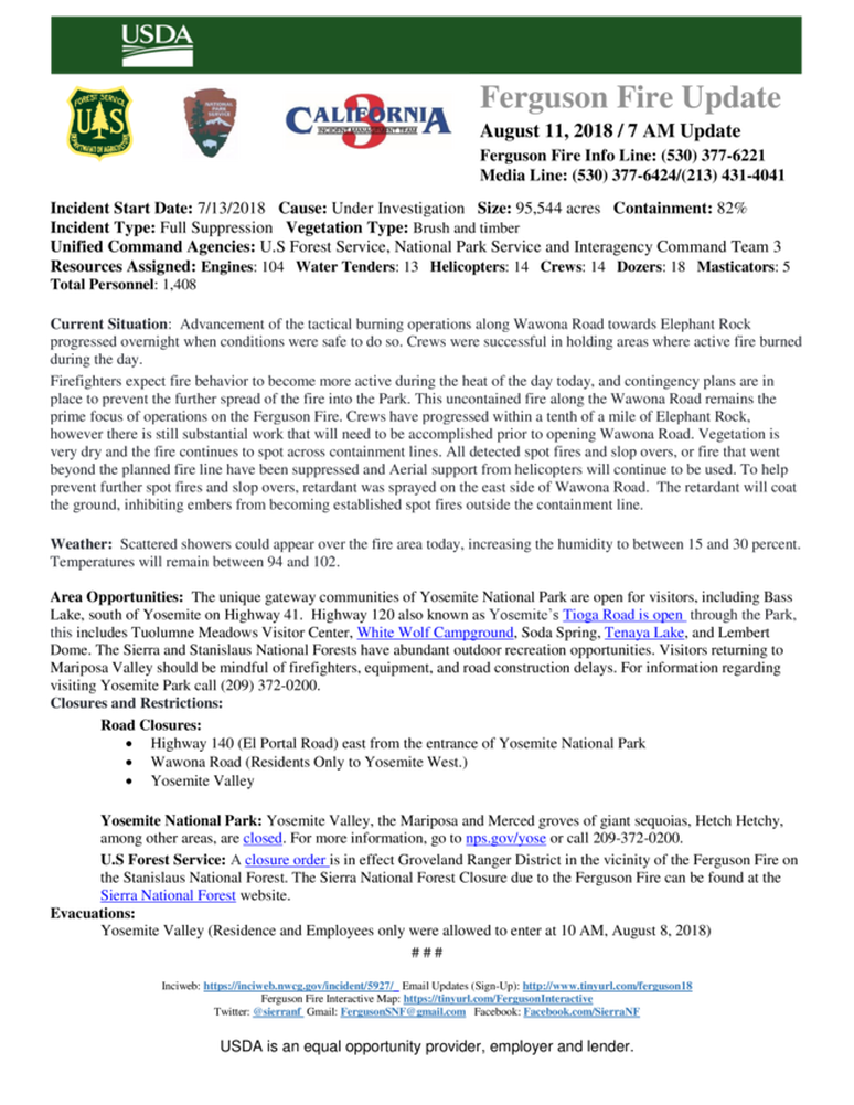
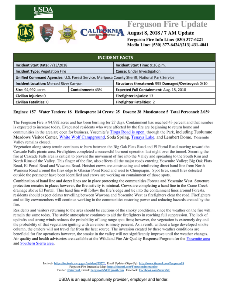
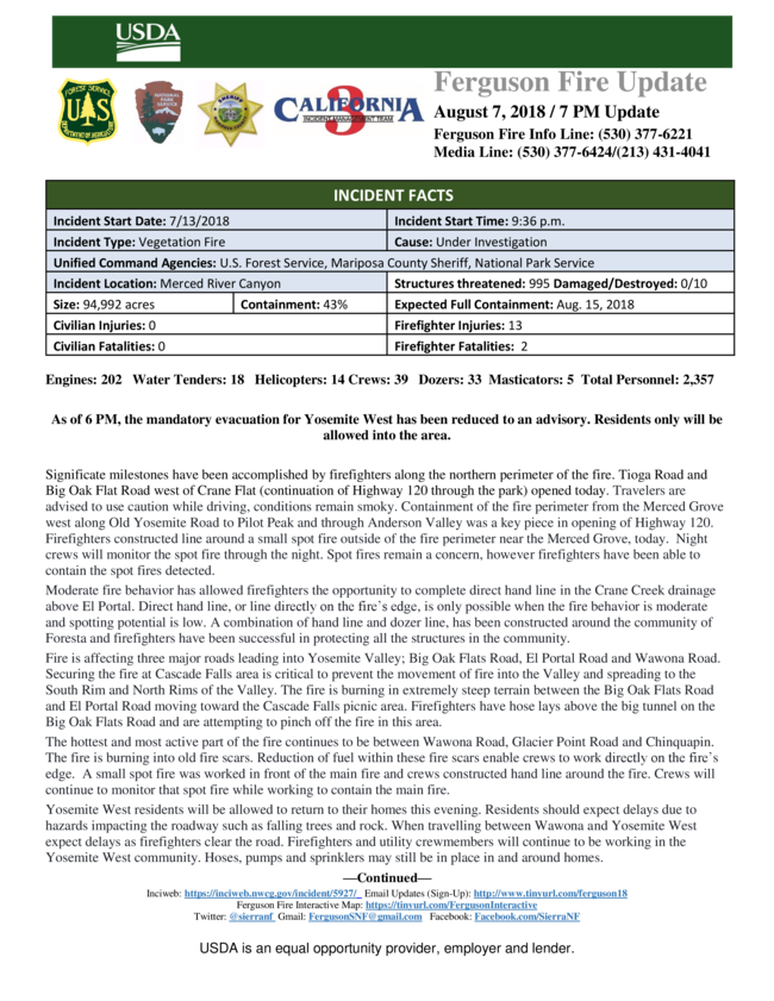
Ferguson Fire Back To 43% Contained
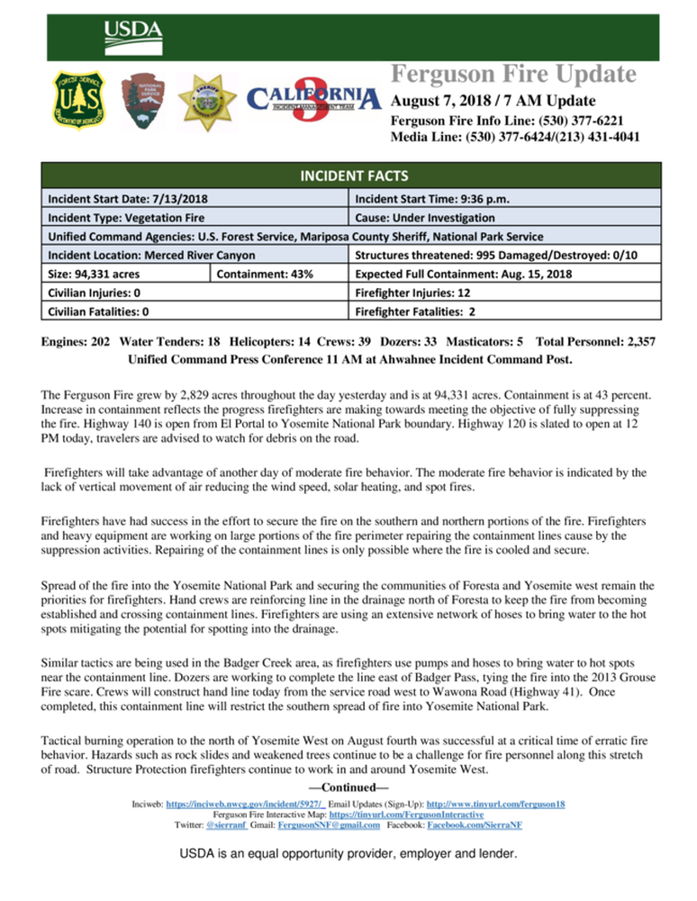
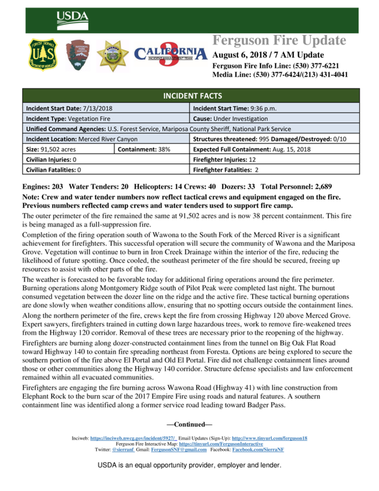
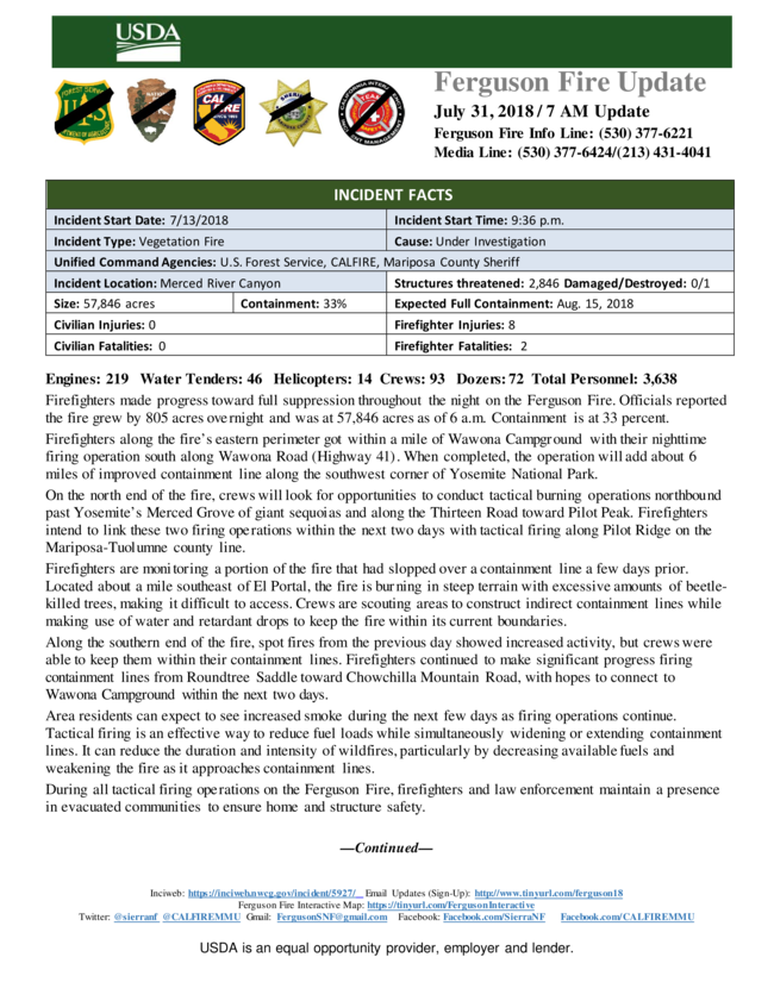
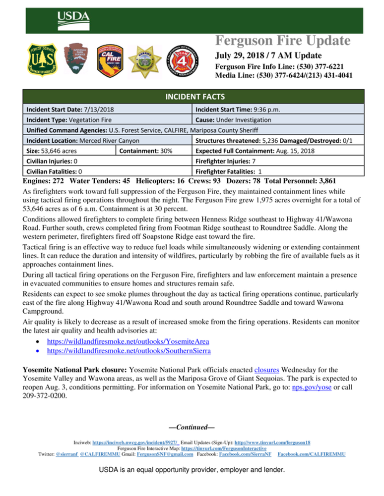
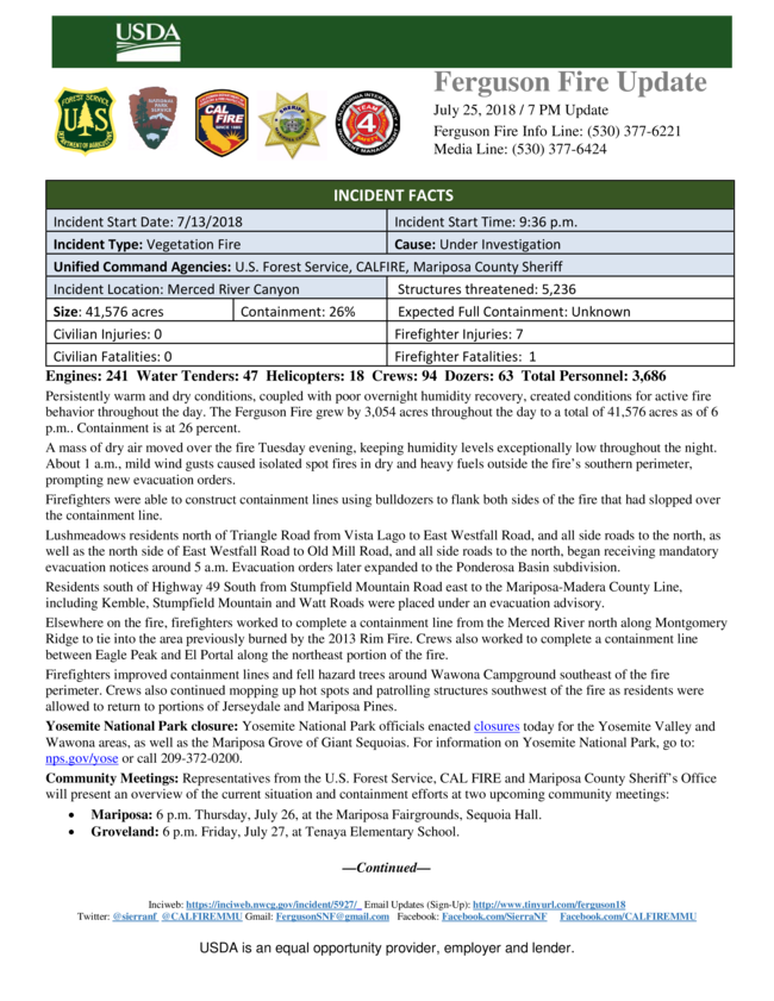
Awahanee, CA, August 7, 2018 - The Ferguson Fire is now 94,331 acres with 43% containment and 2,357personnel that are currently engaged on the fire which include 202 engines, 18 water tenders, 14 helicopters, 39 crews, 5 masticators and 33 dozers. There have been 2 fatalities and 11 injuries to date. 10 structures have been destroyed. The Ferguson Fire is now the largest fire in the Sierra National Forest's History. This fire is being managed as a full suppression fire.
The Ferguson Fire is now in its 26th day; the incident started July 13 on the Sierra National Forest and is managed under unified command between the U.S. Forest Service, California Interagency Incident Management Team 3, and the Mariposa County Sheriff’s Office. Pockets of unburned vegetation remain inside the footprint of the fire, providing a more diversified landscape for plants and wildlife.
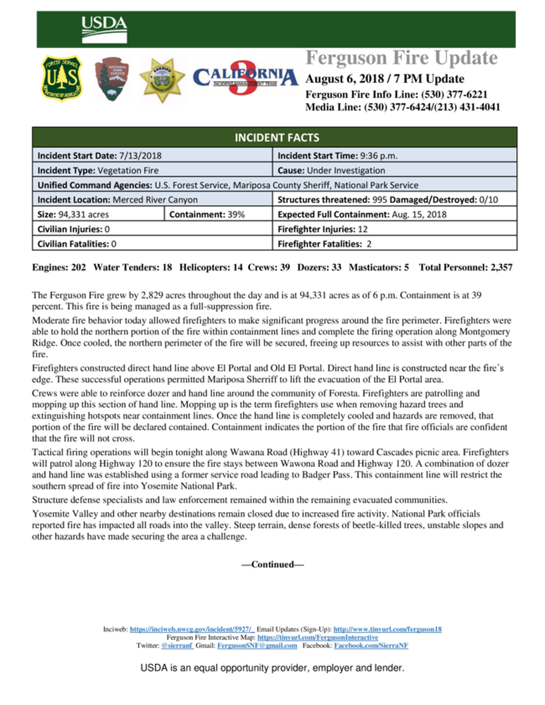
Moderate fire behavior today allowed firefighters to make significant progress around the fire perimeter. Firefighters were able to hold the northern portion of the fire within containment lines and complete the firing operation along Montgomery Ridge. Once cooled, the northern perimeter of the fire will be secured, freeing up resources to assist with other parts of the fire.
Firefighters constructed direct hand line above El Portal and Old El Portal. Direct hand line is constructed near the fire’s edge. These successful operations permitted Mariposa Sherriff to lift the evacuation of the El Portal area.
Crews were able to reinforce dozer and hand line around the community of Foresta. Firefighters are patrolling and mopping up this section of hand line. Mopping up is the term firefighters use when removing hazard trees and extinguishing hotspots near containment lines. Once the hand line is completely cooled and hazards are removed, that portion of the fire will be declared contained. Containment indicates the portion of the fire that fire officials are confident that the fire will not cross.
Tactical firing operations will begin tonight along Wawona Road (Highway 41) toward Cascades picnic area. Firefighters will patrol along Highway 120 to ensure the fire stays between Wawona Road and Highway 120. A combination of dozer and hand line was established using a former service road leading to Badger Pass. This containment line will restrict the southern spread of fire into Yosemite National Park.
Structure defense specialists and law enforcement remained within the remaining evacuated communities.
Ferguson Fire: Wawona Area Spoiled Food Waste Information

WAWONA RESIDENTS: There will NOT be a centralized Food Waste Dumpster for residents BUT rather residents are instructed to use their normal dumpster for depositing their food waste. During the days Wawona was under an evacuation order, there was no power outage, so refrigerators should have kept everything cool, as normal.
Re4cology will schedule more frequent pickups of dumpsters to insure that these materials are removed from the community in a prompt manner.
Mariposa County Public Works will be at the Wawona Fire Station Tomorrow Tuesday August 7th between the hours of 10:00 AM and 3:00 PM to distribute complementary bottled water and cleaning supplies.
Instructions:.
Address/Location
Mariposa County Sheriff's Office
5099 Old Hwy N
Mariposa, CA 95338
Contact
Emergency: 9-1-1
Non-emergencies: 209-966-3615
FERGUSON FIRE: MANDATORY EVACUATIONS ARE LIFTED FOR WAWONA RESIDENTS ONLY!
The Evacuation Orders for the following locations lifted today Monday August 6, 2018 at 10am. This area will be OPEN TO RESIDENTS ONLY and will remain under a Fire Advisement. Fire Advisement- This is an advisement only of a potential Evacuation Order should conditions change.
Evacuation Areas Lifted:
Wawona- All residents will need to use the South Entrance to Yosemite on Highway 41.
Due to the large amount of emergency equipment in the area, speed control will also be enforced.
Evacuation Orders remains in effect for- Yosemite West, Old El Portal, Rancheria Flat- Government Housing, Trailer Court, Foresta, Anderson Valley, Incline Rd, Cedar Lodge, Yosemite View Lodge area and Old Yosemite.
Road Closures in the Area-
Wawona Rd from Chilnualna Falls Rd to Yosemite Valley
Wawona Rd from the South Entrance to Chilnualna Falls- Open to Residents Only
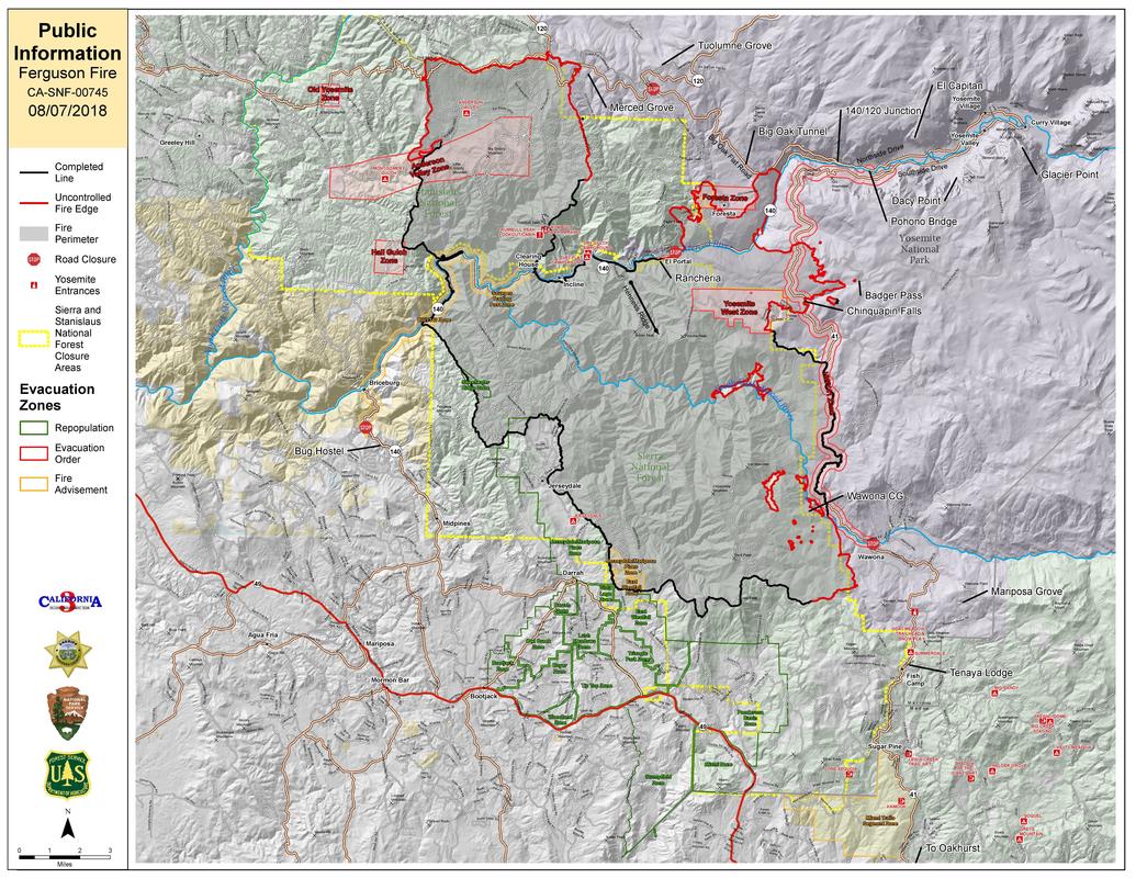
Ferguson Fire Perimeter Map, August 6
Acreage on the fire increased approximately 4,000 acres since yesterday morning. Much of it was due to consumption of pockets of unburned fuel within the So Fork of the Merced River area, and continued spread north and east of Yosemite West and Foresta .
No word for Wawona property owners and residents of when it will be safe to return. Most likely black containment line west of the community must appear on the map before the all clear is provided.
No word for Wawona property owners and residents of when it will be safe to return. Most likely black containment line west of the community must appear on the map before the all clear is provided.
California's fires are creating another problem: Fleeing insurers
By ED LEEFELDT MONEYWATCH
Residents of towns damaged by wildfires may need to prepare for another repercussion: insurers that decide to cancel policies because of increased risks from more frequent fires.
Facing mounting losses, some property insurers are reportedly pulling back from selling policies in California and other western states where wildfire risk is elevated. In California alone, damages had mounted to at least $12 billion by early 2018, while the state's Carr fire likely added another $1.5 billion in insured losses.
The tinderbox conditions in California were already dangerous in January when Insurance Commissioner Dave Jones warned of the "growing problem" of fire insurance unavailability within the state. Now an additional 17 fires are burning throughout the state, including the Carr fire, which has forced 3,800 people to evacuate and scorched nearly 1,000 homes.
California Gov. Jerry Brown has called such conditions "the new normal," with more than two million of the state's households at high or extreme risk of having their homes burn down.
California appears to be a test case for how property insurers are reacting to this new reality. More than 60 uncontrolled fires are now burning across the western U.S., and in seven states more than 13 percent of homes are at risk, according to a study by Verisk Insurance Solutions. In Oklahoma, more than three-quarters of a million acres burned two years ago.
"These more frequent, intense and extensive mega-fires spell trouble for how insurance premiums are priced," said Nik Steinberg, director of analytics at climate intelligence firm Four Twenty Seven.
Anecdotal evidence shows that private insurers are starting to "drop homeowners" with a high exposure to wildfires, he added.
Property insurers denied they are leaving their largest and most profitable market.
"California insurance companies are well-regulated, well-capitalized, and heavily reinsured to protect consumers and ensure claims are paid following major catastrophes like the current 2018 California wildfires," said Vice President Mark Sektnan of the Property Casualty Insurers Association of America. "California continues to have a competitive and healthy homeowner's market."
But homeowners near Santa Rosa, California, which was hard-hit last year by fire, may see it differently. Some homeowners reported cancelled insurance policies. And that is why they are asserting their opinion at the state legislature, where a bill by State Sen. Bill Dodd, whose district includes the fire-hit Napa Valley wine region, would prevent the non-renewal of a homeowner's insurance policy for two years after such a disaster. It has yet to become law.
Currently, non-renewals "are difficult to track," said California Department of Insurance spokeswoman Nancy Kincaid. "Insurers aren't required to report non-renewals. (But) we're advising consumers to call the department's hotline and let us know."
Based on that information, the department estimates non-renewals rose 15 percent from 2015 to 2016.
The most vulnerable homesCalifornia's most vulnerable homes aren't located in cities. Instead, they're found in areas defined as "wildlife-urban interface" – built just close enough to woodlands so that a spark from a tree can set a whole town on fire. An Oakland resident said his policy was terminated because he lived in an "ineligible brush area." It's a pattern that's been repeated over and over in recent years.
A report from Commissioner Jones' office shows that 25 percent of housing is in "high or very high risk" areas in almost half of the state's counties.
"You can see why wildfires are now an everyday threat to life and property for Californians," Jones said in a statement.
And insurers see it too, Jones said. By using sophisticated computer models that include climate projections to determine if some areas of the state are at too high a risk, insurers can then decline to write, or renew policies there, according to Jones. They may also write policies without fire coverage, according to recent news articles.
Current and future laws, like the one Sen. Dodd is trying to pass, could delay the inevitable, but property insurers will almost certainly try to limit their risk in areas where they lose money. It's already happened in Florida and along the East Coast after repeated hurricanes in 2004 and 2005 delivered a "harsh awakening to insurers," said Lynn McChristian, a professor of risk management at Florida State University. Some insurers left the state while others reduced their exposure to coastal areas.
Impact on the property marketIf property insurers leave suburban California, it could minimize the market for new modestly priced homes just as the state is facing a huge homeless population. Another problem: if private insurers drop the ball, it will pass to California's FAIR plan, an organization of all this state's insurance companies, which insures those who can't otherwise get coverage. The cost of such a plan will almost certainly be much higher than a private carrier and also inferior, said Steinberg of Four Twenty Seven.
A homeowner can also opt to purchase insurance from an out-of-state carrier that could pick up the policy, said spokesperson Janet Ruiz, who handles California for the Insurance Information Institute, which represents property-casualty insurers. Among those carriers: the London-based Lloyds syndicate. But these carriers are usually not state-licensed and therefore not as closely regulated.
But one thing is certain. California conflagrations are now a year-round problem, and the Golden State is becoming a model for what other states should and shouldn't do.
"California is the lab for managing exposure to wildfire risk," said McChristian.
YOSEMITE-WAWONA ELEMENTARY CHARTER SCHOOL
Board of Directors Meeting
Wawona Elementary School
Thursday, August 9, 2018, 4:30 PM
Location, In Oakhurst, to be Announced
AGENDA
- CALL TO ORDER
- ROLL CALL
- CONSENT AGENDA
- None
- HEARING OF PERSONS WISHING TO ADDRESS THE BOARD
ACTION ITEMS
- Discuss and approve the delay of the first day of school if evacuations and/or air quality is hazardous
- Discuss student enrollment
- Discuss staffing
- Discuss transportation
- BOARD MEMBER COMMENTS
- Eugene Moisa’s resignation
- STAFF REPORTS
- L CAP Update
- NEXT MEETING DATE
- CLOSED SESSION Personnel/Negotiations/Litigation
- Employee Negotiations (Gov. Code 54957.6)
- Personnel (Gov. Code 54957)
- RECOVENE IN OPEN SESSION: ANNOUNCE CLOSED SESSION ACTIONS
- ADJOURNMENT
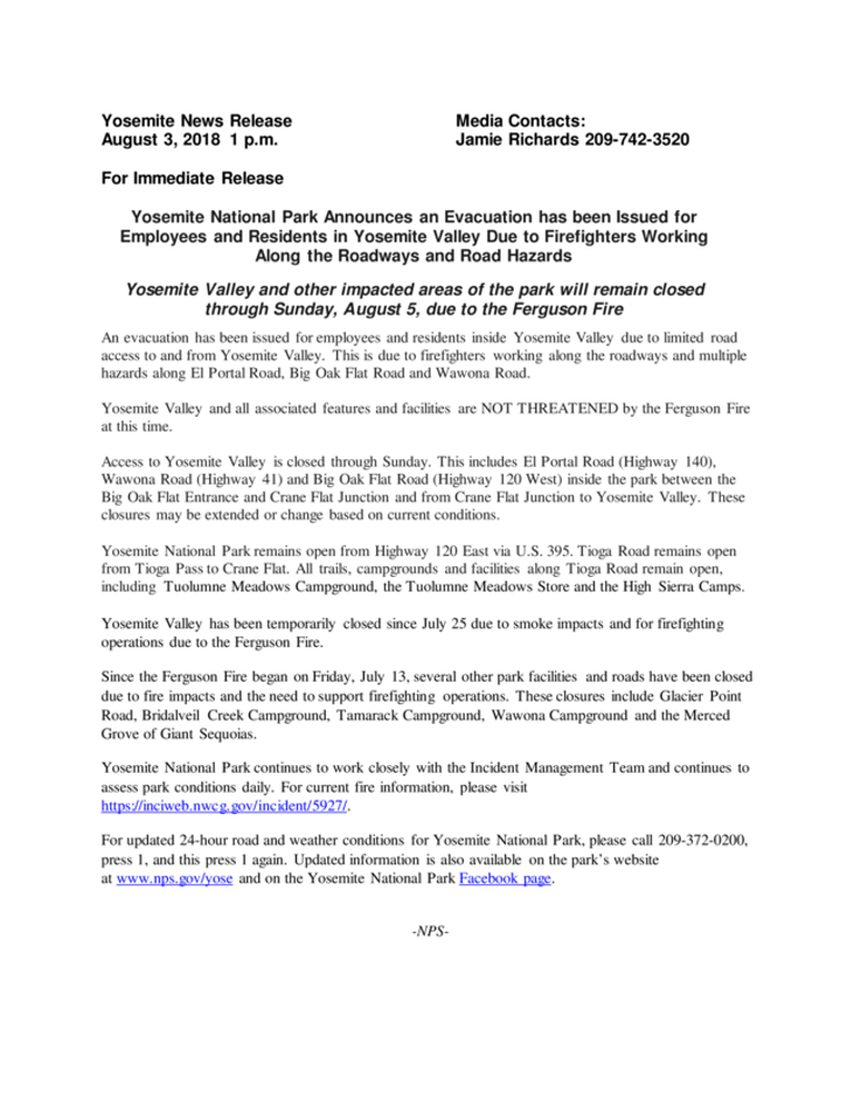
Yosemite Valley and other Sections of the Park Remain Closed Indefinitely Due to Impacts from the Ferguson Fire
Tuolumne Meadows and Tioga Road Remain Open from U.S. 395
Due to increased fire activity in the areas adjacent to and on Yosemite National Park, park administrators and fire managers have made the decision to extend the current park closures indefinitely. Fire managers are continuously assessing conditions in the area and will work directly with and will immediately advise park managers as conditions change and it becomes safe to reopen.
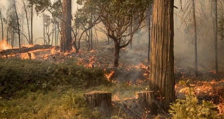
Firefighters remain committed to fully suppressing this fire and are actively engaged, taking action to limit the fire’s spread when it is safe to do so. The fire activity inside Yosemite National Park is dynamic. Over the past 48 hours, fire has impacted all of the roads used to access Yosemite Valley, burning dead and downed trees that can become very explosive and fall without warning. There are also significant terrain hazards for firefighters. These hazards, along with extreme fire behavior and frequent weather changes, have made this an extremely difficult fire fight.
There is active fire burning above the Arch Rock Entrance Station, moving up the Merced River Canyon towards West Yosemite Valley.There is active fire burning near Foresta and structure protection is currently in place. No structures have been lost in the communities of Foresta, El Portal, or Yosemite West. Earlier this week, fire crossed the Wawona Road, following the Indian Creek drainage. This fire has crossed Glacier Point Road, forced firefighters to shelter in place at Badger Pass. To learn more about current fire progression, visit https://inciweb.nwcg.gov/incident/map/5927/.
The following areas remain closed: Yosemite Valley, El Portal Road, Wawona Road, Big Oak Flat Road, Glacier Point, the Mariposa Grove of Giant Sequoias, the Merced Grove of Giant Sequoias, Wawona Campground, Crane Flat Campground, Tamarack Campground, and several other sections of the Park. Please visit www.nps.gov/yose for the most up to date information.
A large portion of Yosemite National Park remains open. Tioga Road from Tioga Pass to White Wolf is open to all visitors and vehicles. Most of the trails and campgrounds along this route, including the Tuolumne Meadows Campground are open. Visitor services along Tioga Road, including the High Sierra Camps and the Tuolumne Meadows Store are open.
The Gateway communities of Sonora, Groveland, Mariposa, Oakhurst, and Lee Vining are great places to recreate and offer a wide variety of opportunities. Please contact the local visitor centers to learn about recreational opportunities in the Gateway communities.
Since the Ferguson Fire began on Friday, July 13, 2018 park visitors, employees, local businesses and communities have all been affected. We realize this has been a difficult time for all involved. Yosemite National Park is committed to supporting our Gateway communities and we will continue to work closely with all of our stakeholders to work through this emergency.
For updated 24-hour road and weather conditions for Yosemite National Park, please call 209-372-0200, press 1 and press 1 again. Updated information is also available on the park’s website at www.nps.gov/yose and on the Yosemite National Park Facebook page.
For the latest information on the Ferguson Fire, visit https://inciweb.nwcg.gov/incident/5927/.
For updated maps of the Ferguson Fire, visit https://inciweb.nwcg.gov/incident/maps/5927/.
-NPS-
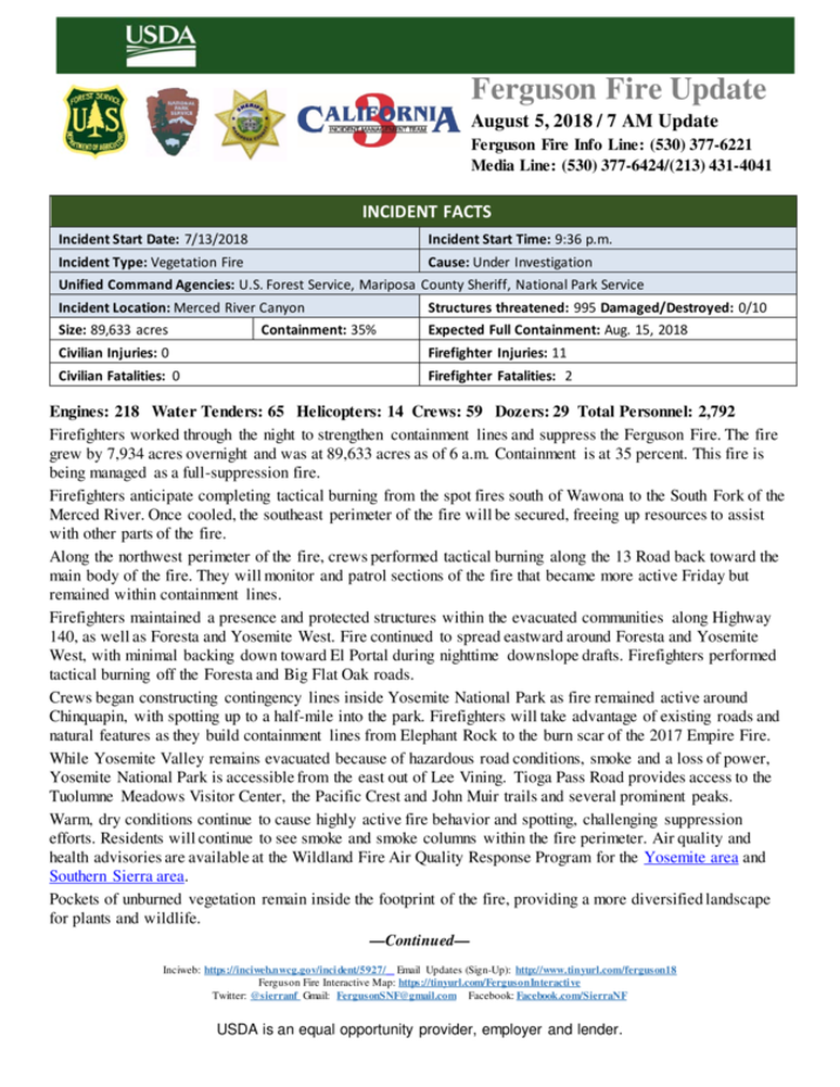
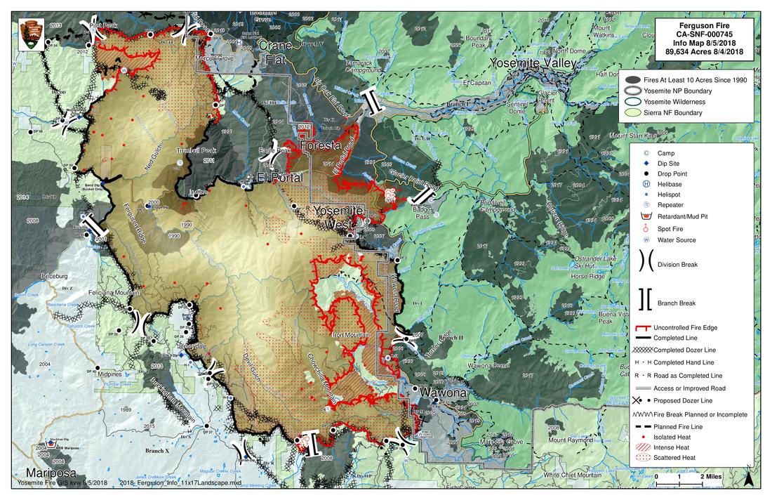
Ferguson Fire Perimeter Map - August 5
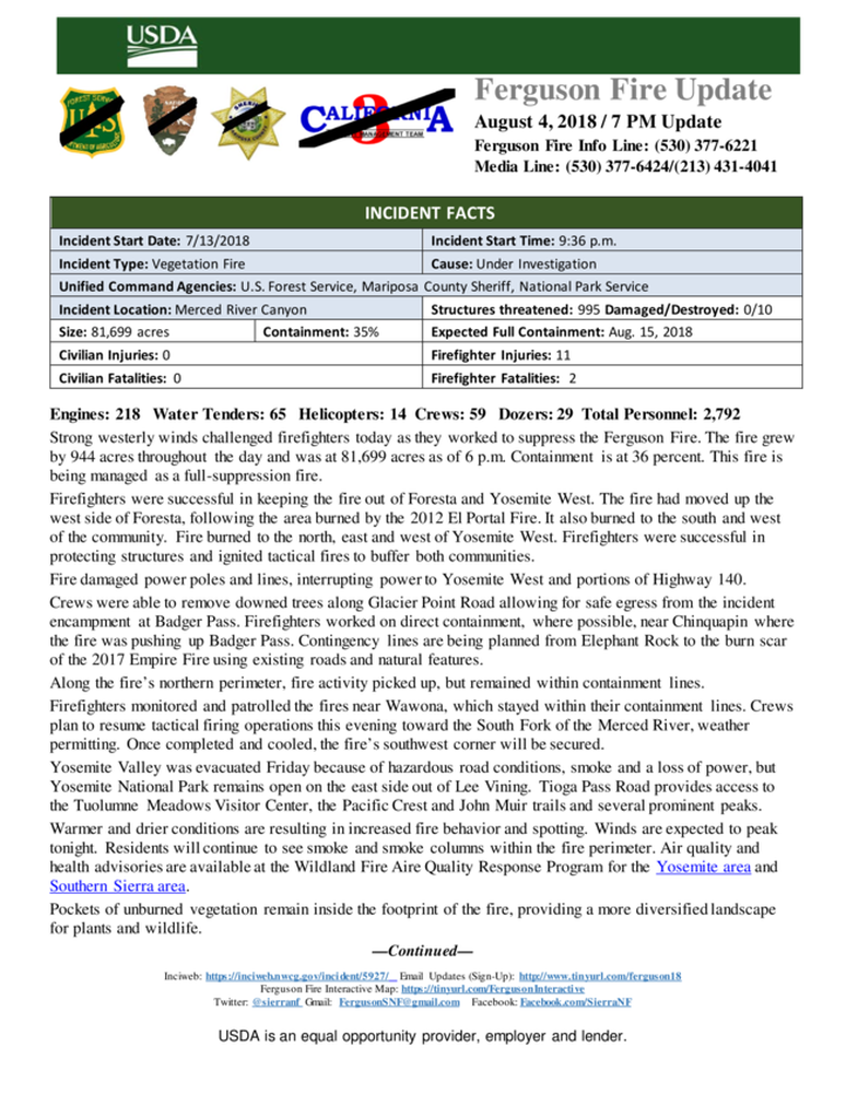
Ferguson Fire Perimeter Map - August 4
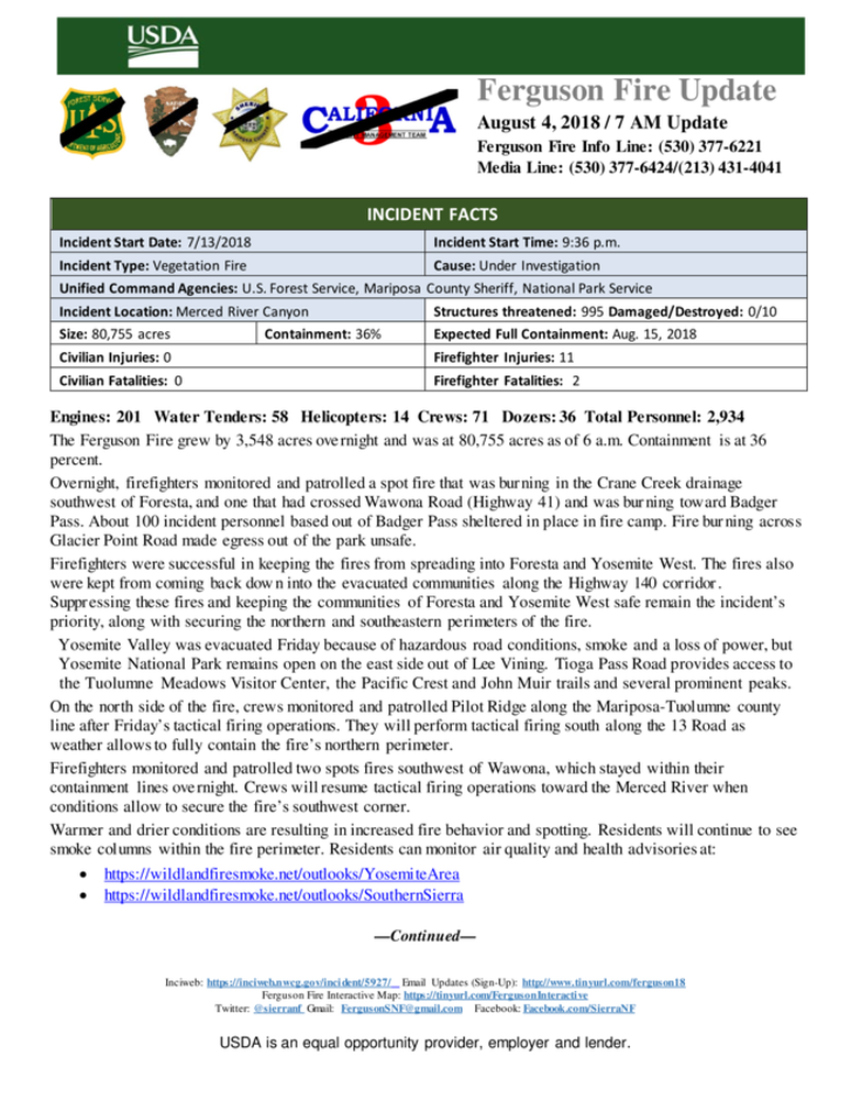
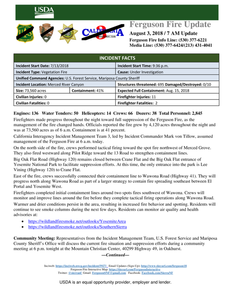
Ferguson Fire Nearly 81,000 Acres, Closures Remain In Place
Posted by: gina clugston August 4, 2018 - 7:20 am ws
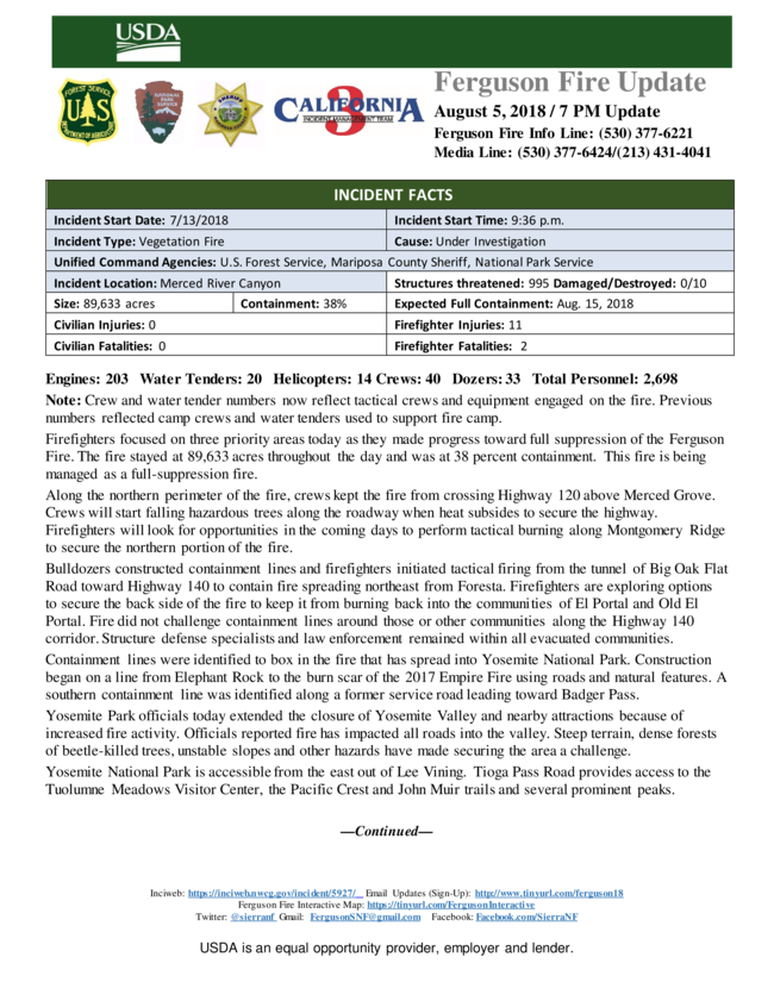
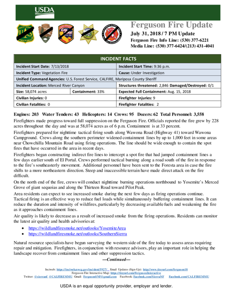
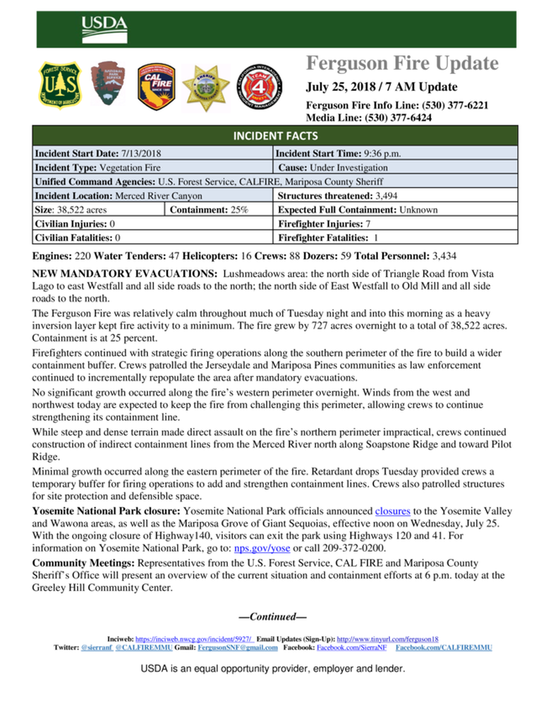
MARIPOSA COUNTY – The Ferguson Fire grew by 3,548 acres overnight as it continued to push to the north and east.
The fire is now estimated at 80,755 acres, and with the expansion of the perimeter into Yosemite National Park yesterday, the percentage of the line that is contained has dropped to 36 percent.
Overnight, firefighters monitored and patrolled the fire that jumped the Merced River yesterday morning and is burning in the Crane Creek drainage southwest of Foresta.
Crews were successful in keeping the fire from spreading into Foresta and Yosemite West, say officials, and also from coming back down into the evacuated communities along the Highway 140 corridor.
Firefighters also monitored and patrolled the fire that spotted across Wawona Road (Highway 41) and is burning toward Badger Pass. Active fire burning across Glacier Point Road made egress out of the area unsafe, and about 100 incident personnel based at Badger Pass sheltered in place in fire camp.
Non-essential personnel in Yosemite Valley were evacuated Friday due to hazardous road conditions, smoke and a loss of power, say park officials. Yosemite Valley has been closed to the public since July 25, however Yosemite National Park remains open on the east side out of Lee Vining, and Tioga Pass Road provides access to the Tuolumne Meadows Visitor Center, the Pacific Crest and John Muir trails.
On the north side of the fire burning on the Stanislaus National Forest, crews monitored and patrolled Pilot Ridge along the Mariposa-Tuolumne county line after Friday’s tactical firing operations. They will fire south along the 13 Road as weather allows, to fully contain the fire’s northern perimeter.
Crews monitored and patrolled two spots fires southwest of Wawona overnight, and held them within their containment lines. When conditions allow, firefighters will resume tactical firing operations toward the Merced River to finish the approximately 1/2-mile of line that will connect the eastern perimeter to the line on the south that runs along Chowchilla Mountain Road.
Officials continue to evaluate the situation on Highway 120 several times a day to determined when it will be safe to reopen. Due to the large amount of burning hazard trees next to the road that firefighters are not able to mitigate, Highway 120 remains closed as of 7 a.m. today. Highway 41 also remains closed. Highway 120 to Lee Vining (Tioga Pass) is the only entrance to Yosemite.
There are 995 structures threatened by the fire. Ten structures have been destroyed, though officials do not believe that any have been recently inhabited.
Damage assessment teams have been able to get into some of the burn areas of the fire, and report that 10 structures have been lost in the Ned Gulch area on the north end of the fire. Officials say it appears that the road had been washed out for some time, requiring teams to go on foot to assess the damage. We will provide more details as they become available.
There is an estimated date for full containment of Aug. 15.
There are currently 2,934 personnel assigned to the incident including 201 engines, 71 crews, 58 water tenders, 36 dozers, 5 masticators, 14 helicopters, and fixed-wing tankers as conditions allow.
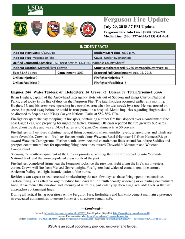
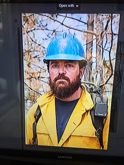
There have been eleven firefighter injuries reported, and numerous instances of heat exhaustion-type symptoms. There have been two fatalities on the fire; HFEO Braden Varney was killed in a dozer rollover accident on July 14, and Brian Hughes, Arrowhead Hotshot Captain, lost his life on Sunday when he was struck by a tree during a firing operation.
If community members see new fire activity, they are asked to call 911, not the fire information line.
As of July 21, there are fire restrictions in place on the Sierra National Forest. Please read and be informed before you use any type of fire in the forest.
The Incident Command Post for the Ferguson Fire is located at the Ahwahnee Hills Regional Park. Please be aware of heavy fire equipment moving through the area. There is also a base camp set up at the ski area at Badger Pass, and another on the Stanislaus National Forest.
Cal Fire has exited Unified Command as of 6 a.m. Thursday because of reduced threats to state and private lands. Cal Fire remains committed to the Ferguson Incident as an assisting agency. California Interagency Incident Management Team 3, led by Incident Commander Mark von Tillow, has assumed management of the Ferguson Fire as of 6 a.m. Friday, Aug. 3, transitioning in for California Team 4, which has be managing the fire since July 19.
For information about the fire please call 530-377-6221.
Relief to Tax and Fee Payers

The California Department of Tax and Fee Administration (CDTFA) will provide relief to tax and fee payers, affected by the wildfires in California. The CDTFA is dedicated to helping our fellow Californians through this difficult time.
Tax and fee payers affected by the wildfires may request the following:
• Extensions to file and pay returns.
• Request relief from penalties and/or interest.
• Request replacement copies of lost or damaged records.
Please call or visit a nearby field office or call our Customer Service Center at 1 (800) 400-7115 for more information. In addition, the CDTFA will have representatives at the CAL OES Local Assistance Centers to provide information.
Ferguson Fire Jumps Highway 41 In Yosemite, Heads For Badger Pass
Posted by: gina clugston August 3, 2018 - 3:35 pm iews
MARIPOSA COUNTY – The Ferguson Fire continues to resists containment efforts as it moves farther into Yosemite National Park.
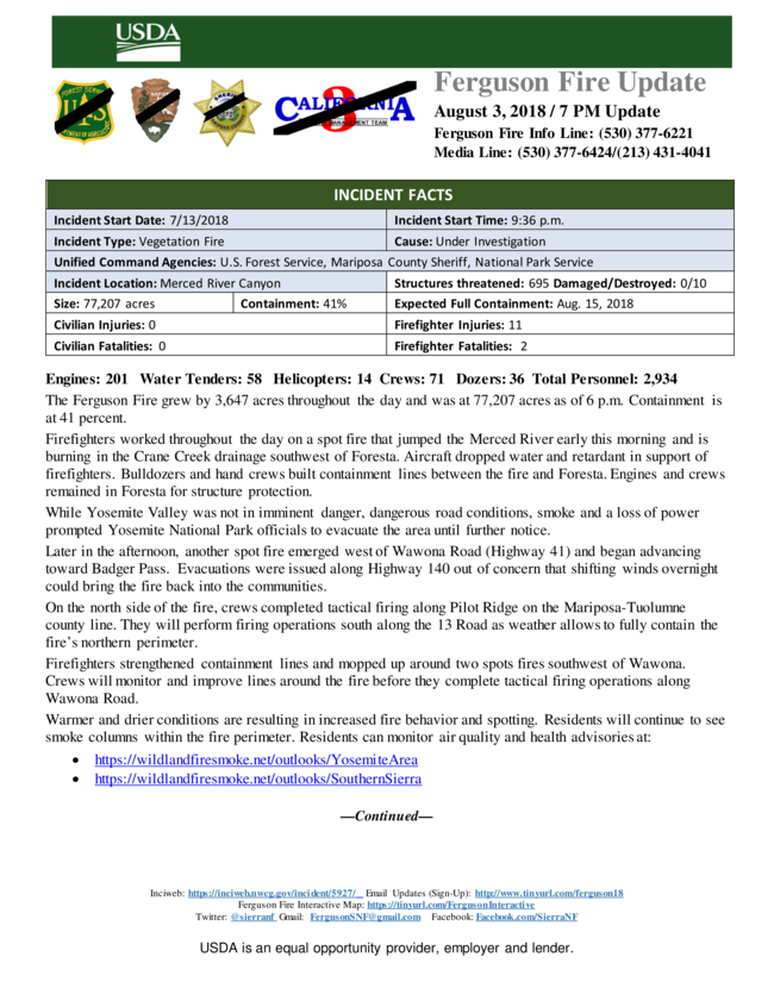
At about 6:30 a.m. today, the fire jumped to the north side of the Merced River about a mile east of El Portal. It quickly became established in Crane Creek and began a run up the mountain toward Foresta, which has been under a mandatory evacuation order since July 20.
Additional resources were sent into Foresta for structure protection and crews engaged in point protection – targeting individual structures – across the community.
Just after 3 p.m., the fire jumped Highway 41 north of Yosemite West and has a good head of steam as it moves up toward the Yosemite Ski and Snowboard area (Badger Pass) where the second fire camp is located.
A hard closure was put in place to keep anyone from going up or down the Glacier Point Road and Highway 41 is also closed at the Tunnel View.
At 3:25 p.m., it was reported that the fire continued to push across Highway 41, and had now crossed the Glacier Point Road and was moving south.
Firefighters in the Fire Camp at Badger Pass are preparing for the fire’s approach. They may have to shelter in place as the likelihood of being able to get out on the Glacier Point Road doesn’t look good. The fire is making a hard push up the mountain.
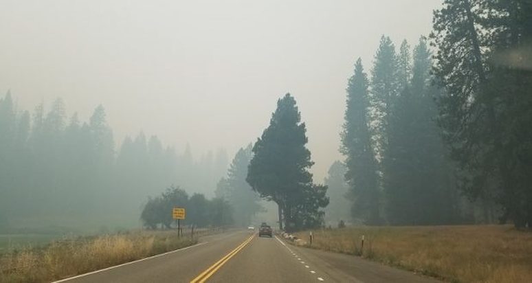
Dense smoke has limited visibility and kept aircraft from engaging for most of the day.
All non-essential personnel were evacuated from Yosemite Valley by noon today.
We will update as conditions develop.
Ferguson Fire Perimeter Map - August 3
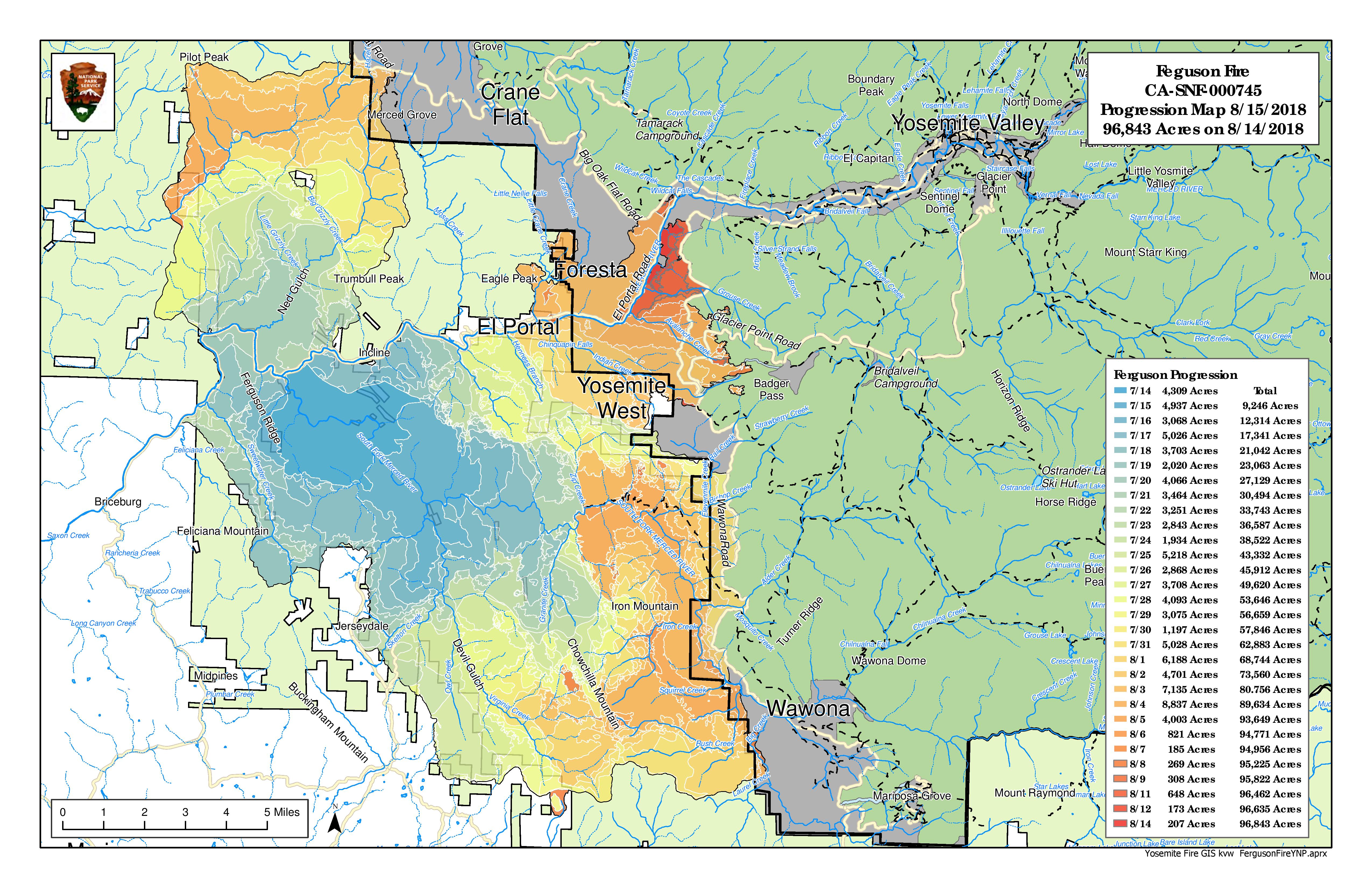 Click on image to enlarge
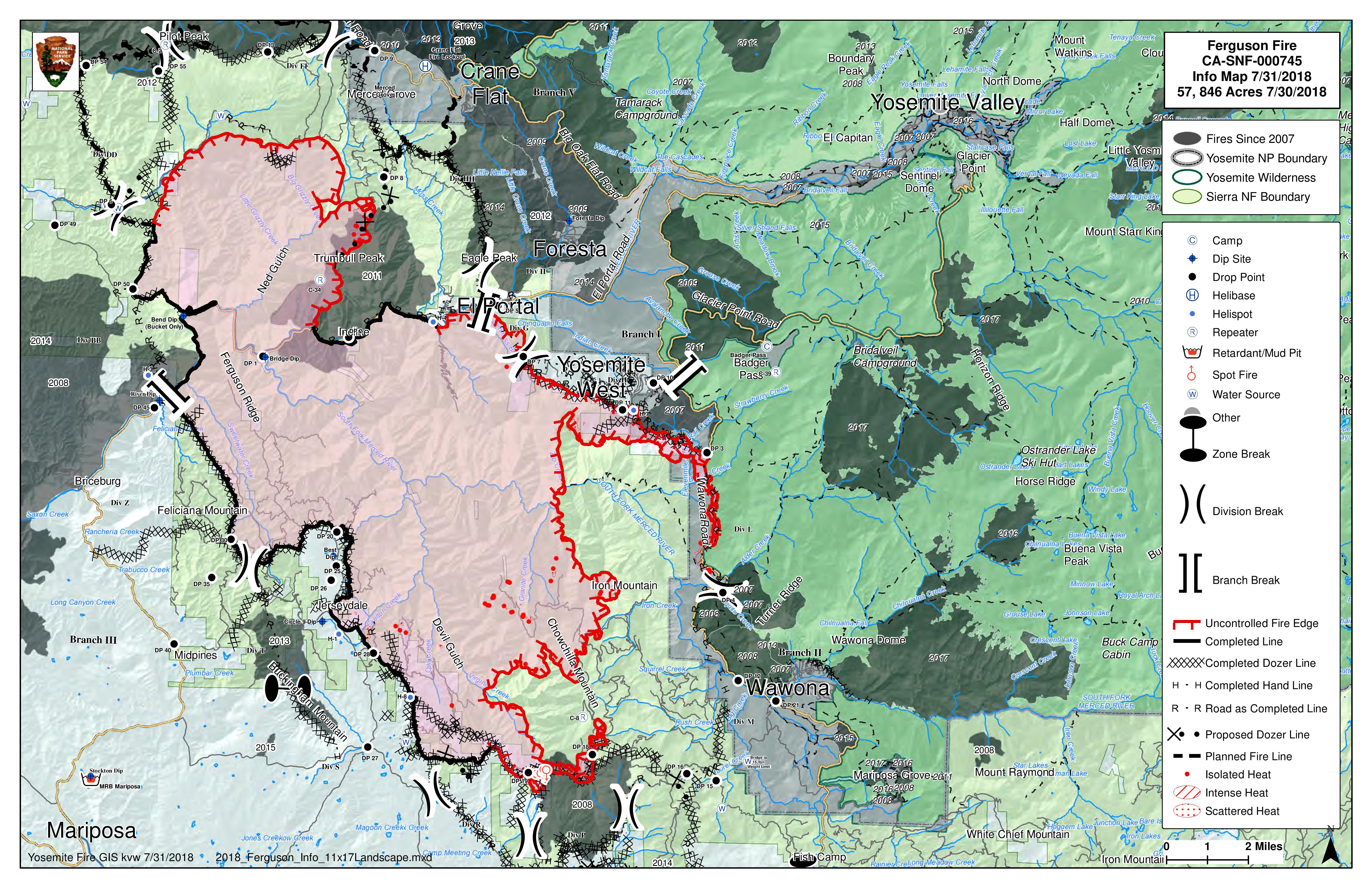
See attached map, produced by Kent Van Wagtendonk, NPS Geographer.
This is day 22 of the Ferguson Fire.
CA Fire Team 4 timed out yesterday and as of 6AM today, a new Federal Team is in place.
The map shows increased containment lines, as well as fire spread near Wawona to the southeast, Yosemite West, El Portal and to the north along Hwy 120 near the Park boundary.
Evacuation orders remain in place for Wawona.
Update From Wawona by Ranger District Eric Sott
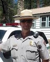
As you all know, we evacuated Wawona last night very unexpectedly and with no prior notice. I wanted to tell you why the order was given and activity that led up to it occurring.
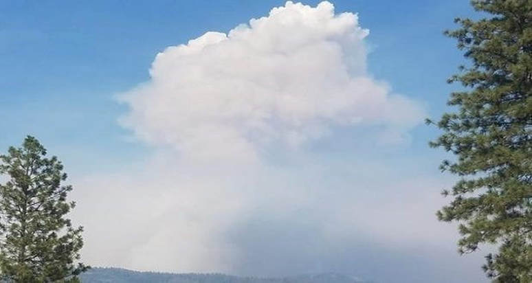
During the day, fire suppression activities were going on as planned in our area. The Division M crews were continuing their line prep and firing operations West up the Chowchilla Mountain Road. The weather forecast did call for the inversion to lift in the afternoon and humidity to drop. As crews conducting their backfiring operations and a very large pyrocumilus cloud was going up. The wind shifted to the SE, and the main fire grew intense and started threatening the line they had been working on and did slop over. At the same time, the smoke column collapsed and started raining lots of ash and chunks of charcoal etc. all over Wawona. The Structural Fire Specialist, who spoke at our last community meeting saw what was happening and called down to Operations at the Command Post in Ahwahnee. I just happened to be there in a meeting with the Ops. Chief and we went from putting out a Fire Advisory Pre-Evac notice, to needing to start an evacuation in less then 10 minutes.
Status today: The slop over created a 47 acre spot fire just above Big Creek on the North side of Chowchilla Mtn. Road. Hotshot crews have been working hard all night and day to check it up. They had planned more backfiring operations this evening, but because the forecast called for similar conditions as last night, and not wanting a repeat of what occurred, this won't take place tonight. If conditions are right tomorrow, they will try backfiring and tie in the spot fire to their main objective, which is the handline by the Wawona Campground.
What this all means is that the Wawona will remain in evacuation status likely for another three days. I go to the ICP every morning for briefings/updates and I will keep you all posted if things change for the better before then.
Hwy. 41 Status: Even when the evacuation for Wawona is lifted, Hwy. 41 North to the Valley is a long way from being open. Active fire on the North side of Yosemite West and the Fire Crews backfiring to keep pace with it will keep the road closed. Fire Ops. plan on bringing the fire and tying it in at Hwy. 41 near Avalanche Creek, or possibly even lower towards the Rostrum. The weather is supposed to change Friday/Sat. bring more winds which makes all fire activity burn more active and increase the risk for spot fires.
Hwy. 120 remains hard closed until a 40 acre spot fire near the Big Oak Flat Road is made safe enough to allow us to open Hwy. 120 back open to the public..
Sorry for the delay in getting some of this info. out. Let me know if you have any questions.
Thanks,
--
Eric Scott
Wawona District Ranger
Yosemite National Park
Office: (209) 375-9520
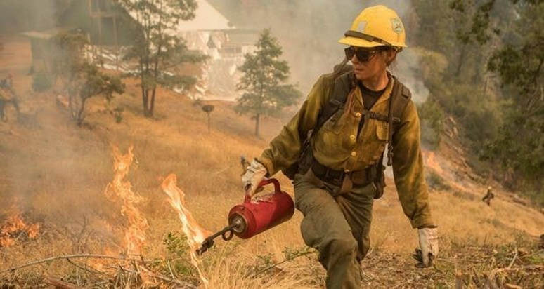
The Ferguson Fire: How Do Firing Operations Work?
Posted by: gina clugston August 2, 2018 - 1:05 pm
MARIPOSA COUNTY – When the Ferguson Fire was first reported just before sundown on Friday, July 13, initial estimates by the first units at scene reported it at about 100 acres. It was burning in extremely steep terrain through very dry fuels, and the Sierra National Forest is ground zero for tree mortality.
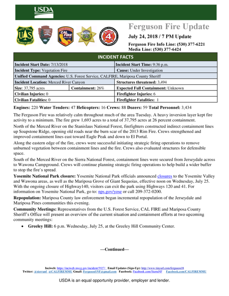
Within 24 hours it had grown to 1,000 acres, and 12 hours later, was estimated at 4,000 acres. So how is a fire this intense and this large managed? One of the tactics used is to conduct firing operations.
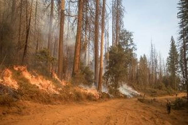
Over the last several days, crews on the Ferguson Fire have been engaged in firing operations on three sides of the fire, to widen the contingency lines and remove fuels as the active edge of the fire approaches.
So why was Highway 41 inside Yosemite National Park chosen as the eastern perimeter? Why didn’t they attack the fire farther to the west instead of letting it burn so far? And why do containment numbers seem so slow to increase?
Jake Cagle, Operations Section Chief for California Interagency Incident Management Team 4 – the team managing the Ferguson Fire – took the time to answers some of those questions. (see map below for Highway 41 branch).
We started with why they chose Highway 41 inside Yosemite for the eastern fireline.
“The topography west of Highway 41 is extremely steep, it’s rugged, it’s inaccessible, and if we did put crews in there, we couldn’t support them,” says Cagle. “Logistically, we couldn’t support them because the area has been under a heavy inversion the whole time. Tactically we couldn’t support them because we couldn’t get aircraft in there to hold all the work they would be doing.”
There are a few roads and trails across the area, but Cagle says they don’t line up with the topography they would have needed to construct effective fireline.
Another reason he cites for not attempting direct attack west of Highway 41 is the tree mortality.
“That’s a huge issue,” says Cagle, who has over 25 years of experience fighting fire. “The tree mortality produces fire effects we’ve never seen before. Fire is burning in a completely different way, and this is being considered a new fuel type. You can’t calculate fire behavior with these fuels; it doesn’t fit the current model. You don’t want to put firefighters down in there.”
Using Highway 41 as a fireline was also a good option because the crown spacing between the trees is open, says Cagle, so it didn’t “torch out” when they put fire on the ground.
“We got really good fire effects in there,” he says. “The fire cleaned up all the stuff on the ground and didn’t get up into the living trees. There are likely a couple pockets where it burned up into the dead trees, but the fire basically stayed on the ground.”
Cagle says those firing operations resulted in a “backing fire” that eased down off the mountain. That will prevent the active edge of the fire moving toward Highway 41 from rushing up the mountain, throwing embers across the line, which is now 1,000 feet wide in some spots, over a mile wide in others.
Planners estimate it will take about two days for the leading edge of the fire to reach the containment line west of Highway 41, which has given them a good window to complete firing operations. They have been prepping this line for nearly two weeks, removing hazard trees and laying down retardant along the “green” side of the line (on the east toward Wawona).
“When it burns together, it will probably be a little hotter in the middle,” says Cagle. “Fire draws its own, so as the activity heats up as the fires come together, they suck each other in.”
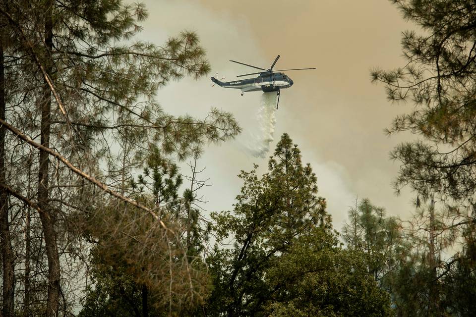
If the fire “gets hung up,” and stops before the fuels are consumed, managers may opt to do aerial firing from helicopters to clean it up and stop any continued smoldering that will keep putting up smoke. This involves using Plastic Sphere Dispensers (PSDs), which are balls filled with potassium permanganate that ignite when they hit the ground and fire off the fuels that haven’t been consumed.
On the southern perimeter of the fire near Roundtree Saddle, planners have been challenge repeatedly by fuel loads and weather as they constructed fireline and prepared for firing operations.
“Initially we go in and punch in the indirect line [fireline that’s out away from the active fire’s edge],” says Cagle. “After we cut dozer line, we then have to go in and do hazard tree mitigation and take out as many trees as we can that would impact the firing operation. If fire would get up into a dead tree and throw embers, we take that tree off the line.”
The slow progress at Roundtree Saddle was largely due to the fuel loads in the burn scar of the 2008 Oliver Fire.
“There were snag patches, old trees, dead trees – all hazard trees,” says Cagle. “It was an overwhelming amount of work and we had fallers and equipment in there trying to mitigate the danger to crews during the firing operations. We had the dozer line cut in there for several days, but it slowed everything down because we had so much prep work to do.”
Planners are now dealing with a large spot fire between El Portal and Yosemite West, that is pushing east through rugged terrain and is now part of the main fire.
“Henness Ridge in that area is a razorback ridge that’s not very accessible for hand crews,” says Cagle. “It’s tough to get safety zones in there and not really a place you’d want your crews to be.
“Up until a few days ago, the fire had minimal activity, and we didn’t want to fire that ridge if we didn’t have to. It could have potentially sat there doing nothing. If we had gotten open air, we would have used tankers and water drops. But now it’s forced our hand, and we’re ready for it. We established a trigger point, which was Zip Creek. It’s hit that trigger point and now it’s starting to get some heat and intensity, so we’re conducting firing operations there.”
One important member of the team for firing operations is the Fire Behavior Analyst. On California Team 4, that is Rob Scott.
“My job is to take weather forecasts and combine that with fuels and topography,” says Scott. “How dry are the fuels? What is the condition of the fuels? How steep and high are the mountains? Then I create a forecast for how the fire is going to burn on the landscape for any given time or day.”
Scott provides firefighters on the line with updates throughout the day, and notifies them when conditions are about to change – information that can affect any planned burning. His fire behavior forecasts have been a critical component to the firing on Highway 41.
“One of the benefits of putting fire on Highway 41 is that it will reduce the length of time that the fire is burning, and reduce its overall size. Also, as we move through time into August and September, the severity and intensity at which the fire will burn will continue to increase. So if this fire were on the landscape in September, it would have been to Highway 41 in a few days. We’ve looked at models and that is a high probability. We can sit on it and wait for it to get to Highway 41, or we can say right now is a pretty good time to burn because the likelihood of a spot across 41 is less than it will be in a couple weeks or a month. The effects of that fire are reduced, and there will be less of an impact on the live trees that are standing.”
Some of the firing operations on this fire have been postponed because the humidity was too high, which seems counter-intuitive.
“So the way fire moves across the landscape, there has to be fine fuels – pine needles and tiny little sticks to move the fire around to logs and bigger branches to really create flames. Fine fuels are very sensitive to changes in relative humidity. When relative humidity goes up, the amount of moisture in the fine fuels goes up. When you apply fire to fuel the first thing that happens is the fuel heats up and it dries out the water vapor. That energy is going into drying out that fuel and not making combustible gases.”
Scott says the magic number for humidity is between 30 and 35 percent. Once it goes above 35 percent, the fire doesn’t move as well and the fuels won’t been efficiently consumed. Conditions need to be right for effective firing operations.
“The primary objective is to stop the spread of the fire,” says Scott. “The secondary objective is to not get the fire so hot that it throws spot fires across the line, so there’s a balance.”
Every meadow, every canyon, every ridgetop in the very large footprint of this fire has its own unique weather conditions. For example, one big challenge for crews has been the northerly winds out of Devils Gulch in the late afternoon and evening. Scott says they stopped putting fire on the ground at about 3 p.m., allowing the fire to burn down before the winds came so as to avoid ember cast toward Ponderosa Basin.
The final question for Operations Section Chief Jake Cagle was about containment. Why is that number hanging around in the 30+ percent range for so many days?
“It’s tough to continue containment when fire is growing within itself,” says Cagle. “We had one day where we contained five miles of line, but the fire made such progression on the interior – because that counts, it’s consumable acres – that shrinks the percentage.”
A section of fireline is moved into the “contained” column and indicated by a black line on the map when officials are confident that it’s secure and there is no chance for a flare-up that would threaten life or property. That doesn’t mean there isn’t line around the whole fire.
Footman Ridge is a good example of caution when it comes to calling something “contained.”
“We’ve been battling that for days and it’s pretty cold,” says Cagle. “But we’re waiting and waiting because we’re still apprehensive. We still get that north wind in the evening, and even had a spot there Tuesday night, but it was picked up quickly. We have to be sure it’s secure before we put black on it.”
Jake Cagle has been a member of the California Interagency Incident Management Team 4 since 2007, and is a Fire Captain at the Kern County Fire Department.
Rob Scott is a Fuels Officer on the El Dorado National Forest and is from Diamond Springs, Calif.
Smoke From 68,610-Acre Ferguson Fire Closes Highway 120
Posted by: gina clugston August 2, 2018 - 7:26 am
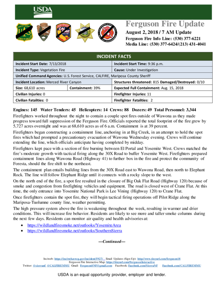
MARIPOSA COUNTY – The Ferguson Fire grew by 5,727 acres overnight and is now estimated at 68,610 acres with 39 percent containment.
Officials are reporting this morning that a spot fire on the north has resulted in the closure of Big Oak Flat Road (Highway 120) because of smoke and congestion from firefighting vehicles and equipment.
The road is closed west of Crane Flat. At this time, the only entrance into Yosemite National Park is Lee Vining (Highway 120) to Crane Flat.
Firefighters worked throughout the night to contain a couple spot fires that jumped the line on the southeast perimeter at about 5 p.m. yesterday, forcing the evacuation of Wawona. Crews are working to construct a containment line, anchoring in at Big Creek, in an attempt to hold the spot fires. Officials anticipate having the line completed by midday.
The communities of Yosemite West and Foresta remain under a mandatory evacuation as the northeastern portion of the fire continues to grow, south of the Merced River.
Firefighters kept pace with that section of fire, say officials, and matched the fire’s moderate growth with tactical firing along the 30X Road to buffer Yosemite West. Crews also prepared containment lines along Highway 41 to further box in the fire and protect the community of Foresta, should the fire shift to the northeast.
The containment plan entails building lines from the 30X Road east to Wawona Road, then north to Elephant Rock. The line will follow Elephant Ridge until it connects with a rocky slope to the west.
On the north end of the fire, a spot fire resulted in the closure of Big Oak Flat Road (Highway 120) because of smoke and congestion from firefighting vehicles and equipment. The road is closed west of Crane Flat. At this time, the only entrance into Yosemite National Park is Lee Vining (Highway 120) to Crane Flat.
Once firefighters contain the spot fire, they will begin tactical firing operations off Pilot Ridge along the Mariposa-Tuolumne county line, weather permitting.
Officials have reduced the number of structures threatened by the fire to 815. No homes have been lost. One non-residential structure has been destroyed.
There is an estimated date for full containment of Aug. 15.
There are currently 3,344 personnel assigned to the incident including 145 engines, 88 crews, 45 water tenders, 49 dozers, 14 helicopters, and fixed-wing tankers as conditions allow.
There have been eleven firefighter injuries reported, and numerous instances of heat exhaustion-type symptoms. There have been two fatalities on the fire; HFEO Braden Varney was killed in a dozer rollover accident on July 14, and Brian Hughes, Arrowhead Hotshot Captain, lost his life on Sunday when he was struck by a tree during a firing operation.
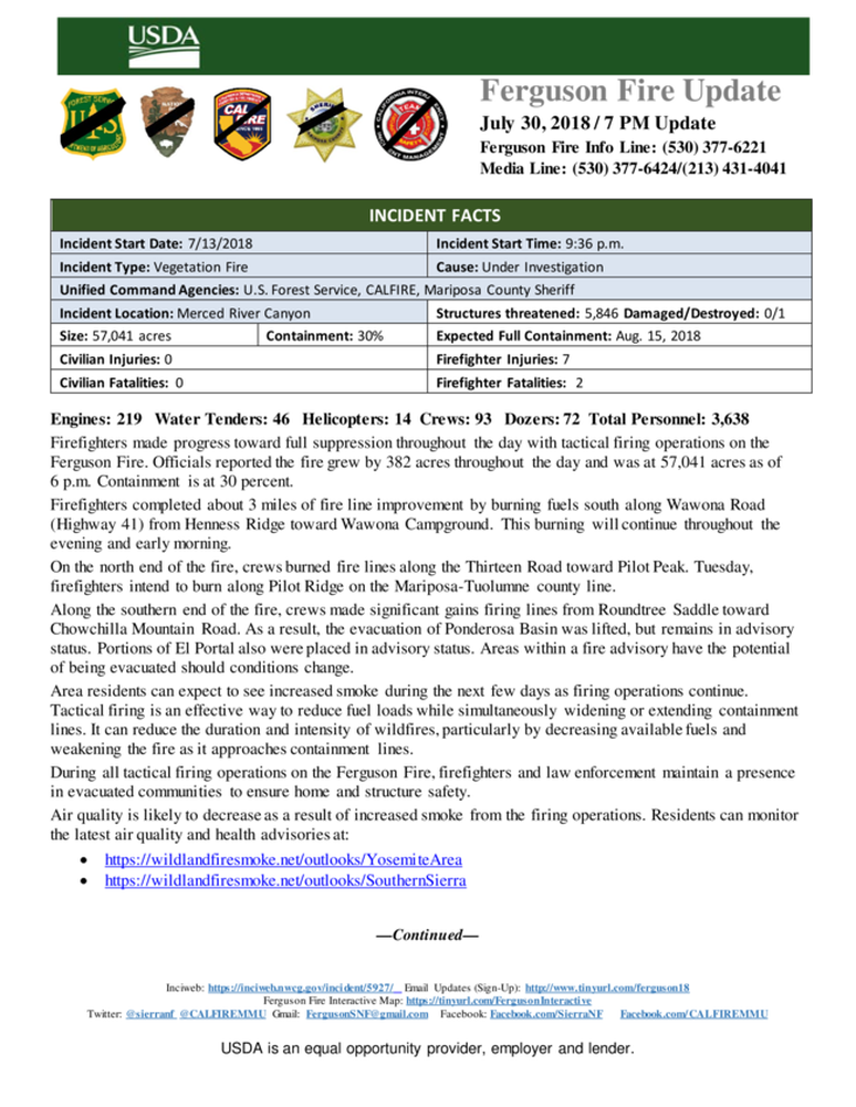
Area residents can expect to see increased smoke during the next few days as firing operations continue. Tactical firing is an effective way to reduce fuel loads while simultaneously widening or extending containment lines. It can reduce the duration and intensity of wildfires, particularly by decreasing available fuels and weakening the fire as it approaches containment lines.
During all tactical firing operations on the Ferguson Fire, firefighters and law enforcement maintain a presence in evacuated communities to ensure home and structure safety.
The high pressure system above the fire is weakening which will result in warmer and drier conditions. With lower winds speeds and the inversion layer forecasted to lift by midday, residents are likely to see taller smoke columns than they are used to seeing. Residents can monitor the latest air quality and health advisories at:
- https://wildlandfiresmoke.net/outlooks/YosemiteArea
- https://wildlandfiresmoke.net/outlooks/SouthernSierra
This closure is based on the current and expected fire behavior and will be in effect until Sept. 30, or until replaced or rescinded. Click here for details and a map of the closure.
Yosemite National Park
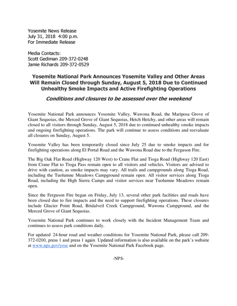
Officials have announced that the closure of some portions of Yosemite National Park will be extended to Aug. 5. This now includes Hetch Hetchy. When the park does open these areas, limited visitor services will be available inside Yosemite Valley, including campgrounds, lodging, and food service operations.
Yosemite Valley has been temporarily closed since July 25 due to smoke impacts and for firefighting operations along El Portal Road and the Wawona Road due to the Ferguson Fire.
The Mariposa Grove of Giant Sequoias and the Wawona Road (Highway 41) from the south entrance of Yosemite National Park to Tunnel View will remain closed until further notice.
The Big Oak Flat Road (Highway 120 West) to Crane Flat and Tioga Road (Highway 120 East) from Crane Flat to Tioga Pass, remain open to all visitors and vehicles. All trails and campgrounds along Tioga Road, including the Tuolumne Meadows Campground remain open. All visitor services along Tioga Road, including the High Sierra Camps and visitor services near Tuolumne Meadows, remain open.
Since the Ferguson Fire began on Friday, July 13, several other park facilities and roads have been closed due to fire impacts and the need to support firefighting operations. These closures include Glacier Point Road, Bridalveil Creek Campground, the Wawona Campground, and the Merced Grove of Giant Sequoias.
Yosemite National Park continues to work closely with the Incident Management Team and continues to assess park conditions daily.
For updated 24-hour road and weather conditions for Yosemite National Park, please call 209-372-0200, press 1 and press 1 again. Updated information is also available on the park’s website at www.nps.gov/yose and on the Yosemite National Park Facebook page.
As of July 21, there are fire restrictions in place on the Sierra National Forest. Please read and be informed before you use any type of fire in the forest.
The Incident Command Post for the Ferguson Fire is located at the Ahwahnee Hills Regional Park. Please be aware of heavy fire equipment moving through the area. There is also a base camp set up at the ski area at Badger Pass.
The fire is under Unified Command with Cal Fire, U.S. Forest Service, Yosemite National Park and the Mariposa County Sheriff’s Office. Management of the fire transitioned to a Type 1 Management Team – California Team 4 – on Thursday, July 19. For information about the fire please call 530-377-6221.
The Ferguson Fire started on Friday, July 13, at 8:30 p.m., near Savage Trading Post on the south side of the Merced River canyon along Highway 140. The cause remains under investigation.
Be sure you are signed up to receive alerts when wildfire or other emergencies threaten.
- To sign up for the Mariposa Sheriff’s Office Emergency Alert System visit https://local.nixle.com/register.
- To register for the Madera County Sheriff’s Office Emergency Alert System visit mcalert.org.
Residents can check the San Joaquin Valley Air Pollution Control District’s wildfire page at www.valleyair.org/wildfires for information about any current wildfires and whether they are impacting the Valley. The District’s Real-time Air Advisory Network (RAAN) provides localized air quality data from an extensive air-monitoring network which allows Valley residents to track PM at any Valley address by visiting myraan.com.
Evacuations
New yesterday: A mandatory evacuation order has been issued for the community of Wawona as of 6 p.m. yesterday. Residents should leave on Highway 41 to the south gate. This evacuation has been done as a precaution, according to officials.
The Evacuation Orders were lifted 7 p.m. for El Portal Trailer Park. This area will be open to residents only and will remain under a Fire Advisement. All residents will need to use the ENTRY POINT on Highway 140 in the Midpines area. The evacuation order remains in effect for Old El Portal and Park Line/ Yosemite View Lodge area.
Evacuations lifted for Highway 140 Corridor – This area will include the following for RESIDENTS ONLY:
- Savage Trading Post
- Cedar Lodge
- Indian Flat
- Incline Road
- Rancheria Flat- Government Housing & National Park Service
- El Portal Complex
All residents will need to enter using Highway 140 in the Midpines area. The road remains closed to the public.
Mandatory evacuations remain in place for:
- Wawona
- Old El Portal
- River Road from Briceburg to last BLM Campground
- Foresta
- Yosemite View Lodge
- Yosemite West
- Anderson Valley
- Old Yosemite Road
- Cedar Lodge/Indian Flat Campground
- Rancheria Flat and all campgrounds along Highway 140
- Savage Trading Post
- El Portal Trailer Park
A Red Cross Evacuation Center has been established at Mariposa Elementary School at 5044 Jones Street in Mariposa. This shelter is accepting small pets with their owners.
The shelter at Mountain Christian Center at 40299 Highway 49 in Oakhurst has been closed due to lack of need by evacuees. They remain on standby and will reopen if conditions warrant.
The shelter at New Life Christian Church located at 5089 Cole Road in Bootjack has been closed.
If you have been evacuated due to the Ferguson Fire, the Sheriff’s Office asks that you please check in with the Red Cross Shelter even if you do not plan to stay there.
If you are in a Mandatory Evacuation or Advisory Area and may require assistance with evacuation transportation due to special needs or medical issues, please contact Human Services toll free at 1-833-423-0816 as soon as possible.
Planning ahead will help with a safe and timely evacuation.
Animal Evacuation Centers
Small Animal Shelter is at SPCA of Mariposa County, 5599 Highway 49 in Mariposa is at full capacity.
Residents with small pets can be accommodated at the Mariposa Elementary School Shelter at 5044 Jones Street for those under mandatory evacuation, where Central California Animal Disaster Team (CCADT) is operating an emergency animal shelter. You must check in with Red Cross first. Please try to accommodate your pets with family and friends first, however your pet is welcome to be sheltered if necessary at the Mariposa Elementary School. For questions about pets, please call CCADT at 888-402-2238 ext. 0, and leave a message. Someone will return your call as soon as possible.
Large Animal Shelter is at the Mariposa County Fairgrounds, 5007 Fairgrounds Roadin Mariposa.
Road Closures
- Anderson Valley Road
- Foresta Road
- River Road from Briceburg to the gate at Railroad Flat and all campground areas along 140
- Summit Road
- Old Yosemite Road
- Wawona Road (Highway 41) between Chilnualna Falls in Wawona and Bridalveil Road in Yosemite Valley
- Incline Road and Highway 140 from the entrance to Yosemite National Park to 1.5 miles east of Midpines are closed to everyone except residents.
- Big Oak Flat Road (Highway 120) west of Crane Flat
General information on returning to previously evacuated areas:
Mariposa County Sheriff’s Office will have a heavy presence in the area to ensure the security and safety of residents and businesses.
There will still be smoke in the respective areas as firefighters continue firefighting operations. If at any time you feel unsafe, please call 911.
For questions or concerns regarding power, please contact PG&E at 800-743-5000 or visit their website at www.pge.com.
The Mariposa County Health Department has health and safety information for residents returning to their homes on their website at http://www.mariposacounty.org/health or call 209-966-3689.
Mariposa County Health and Human Services will be available to assist residents with gaining additional services. Additional information regarding these and other services is available at www.mariposacountyrecovers.org.
SAFETY MESSAGE – The public is reminded to stay vigilant on current fire conditions. Please continue to adhere to road closures and any evacuation warnings. If you see electrical wires on the ground, stay clear and contact PG&E immediately. Trees and poles with deep charring, particularly if still smoking, should be considered hazardous. Please drive slowly and yield to emergency personnel in the area. As you re-enter your property and evaluate damage, be aware that hazardous conditions may exist, particularly if a residence or out-building has burned. Hazards may include asbestos, heavy metals, by-products of plastic combustion and various other chemicals. We encourage the public to remain prepared year-round for wildfires by visiting the www.readyforwildfire.org website. The best show of support is having your home and property “fire-ready.”
Cooperating Agencies on the Ferguson Fire include:
- Bureau of Land Management
- California Conservation Corps
- California Department of Corrections
- California Highway Patrol
- California Office of Emergency Services
- Caltrans
- Central Califonia Animal Area Disaster Team
- Madera County Sheriff
- Mariposa County Public Works
- Mariposa Public Works
- National Weather Service
- North Fork Rancheria of Mono Indian of California
- Pacific Gas and Electric
- Red Cross
- Sierra Tel
- Tuolumne County Sheriff
The Latest From Wawona
|
Wawona - 8:43 PM, Aug. 1st
The latest from the vacation rental employees who are going around shutting all homes, disconnecting propane tanks, generators, removing flammable items from decks, and turning off power before they evacuate, is that at the time of this post, the evacuation order is a precautionary measure. There are fire spots on the west side of 41, in the proximity of the campground and there is concern that if these should jump the road and block Chilnualna Falls Road, there would be no way out. A DC10 was dropping fire retardant in the area earlier today. |
Alert: Ferguson Fire: Mandatory Evacuation Order for Wawona
August 1st, 6:58 PM
A MANDATORY EVACUATION ORDER has been issued for:
The Community of Wawona
Please use Wawona Rd to Highway 41 to safely exit the area. Wawona Rd to Highway 140 remains closed.
You can begin evacuating now, Yosemite National Park Service and Mariposa County Sheriff's Office are currenty in the area contacting residents.
A Red Cross Shelter has been established at the New Life Christian Church located at 5089 Cole Rd in Mariposa.
Please drive with caution and watch for responding emergency traffic.
Safety Message: The public is reminded to stay vigilant on current fire conditions. Please continue to adhere to road closures and any evacuation warnings. If you see electrical wires on the ground, stay clear and contact PG&E immediately. Trees and poles with deep charring, particularly if still smoking, should be considered hazardous. Please drive slowly and yield to emergency personnel in the area. As you re-enter your property and evaluate damage, be aware that hazardous conditions may exist, particularly if a residence or out-building has burned. Hazards may include asbestos, heavy metals, by-products of plastic combustion and various other chemicals. We encourage the public to remain prepared year-round for wildfires by visiting the www.readyforwildfire.org website. The best show of support is having your home and property “fire-ready
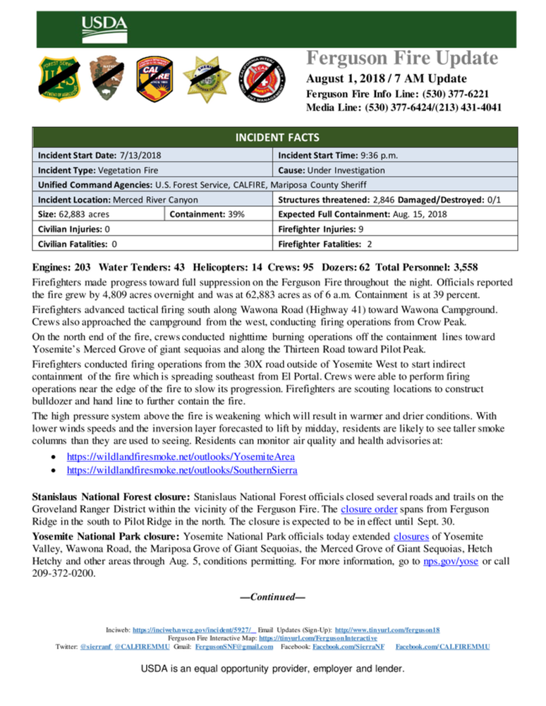
Ferguson Fire Nearly 64,000 Acres, Wawona Evacuated
Posted by: gina clugston August 1, 2018 - 7:14 pm
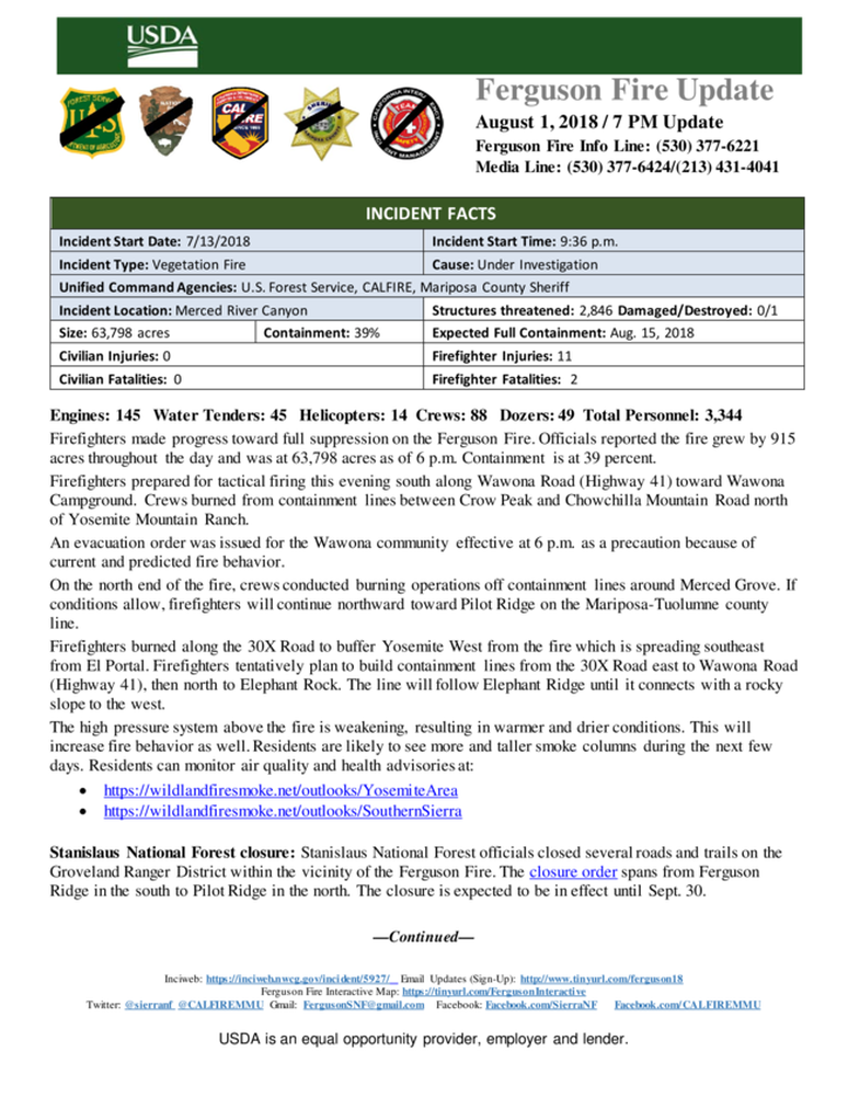
MARIPOSA COUNTY – The Ferguson Fire is now estimated at 63,798 acres with 39 percent containment. The fire grew by 915 acres today.
Just before 6 p.m., several spot fires outside the lines on the southeast corner, and falling embers, prompted the evacuation of the community of Wawona inside Yosemite National Park. Officials say the evacuation was precautionary.
At 7 p.m., the evacuation order was lifted for the El Portal Trailer Park on Highway 140 (see details below).
North of the Merced River on the Stanislaus National Forest, the western flank of the fire has been fairly quiet for several days and has been showing “really cold” on the infrared cameras, so planners have held off on firing farther up the Thirteen Ridge. They have cut a line that shrinks the size of the box in which they’re burning.
Winds have been inconsistent across the northern perimeter, holding up firing operations which crews will continue with when conditions are favorable. Planners hope to have burning completed across Pilot Ridge in the next 24 to 48 hours.
On the east side above the river, crews made good progress firing just off of the old Coulterville Road last night, up to the park boundary. Everything remains within the current containment lines. There are still closures for Anderson Valley and Little and Big Grizzly Flats as well as Old Yosemite Road. All closures will remain in effect until mop-up is complete, expected in the next few days.
South of El Portal, the fire continues to push east parallel to, and south of, the Merced River. What began a few days ago has a spot fire is causing evacuations to remain in place for Yosemite West, Old El Portal and Foresta. Planners have crews firing along the 30X Road, staying even with the fire’s progress.
While crews are keeping ahead of the fire along the 30X Road, other resources are cutting contingency line from there over to Highway 41. The plan is to put in line north and catch Elephant Ridge, a large granite ridge that runs northwest to the Merced River. That will add about another 2,000 acres to the “big box.” If the weather changes and the fire doesn’t move, that will give planners the opportunity to make the box smaller.
Crews finished firing south on Highway 41 inside Yosemite National Park on the west side of Wawona Campground and got it tied in down to the river last night. The fireline is now more than 1,000 feet deep in most places. Just before 6 p.m., the fire spotted across the line in several places. An air tanker is laying retardant across the head of the fire, two heavy helicopters are working the flanks, and crews and dozers are working those spots as of this posting.
There is still one small piece to complete on Old Chowchilla Mountain Road that is about a mile-and-a-half long, and then the line around the southeast corner will be tied in. Once that line is complete, crews can start mopping up inside the line.
In the Footman Ridge area, there was minimal spotting last night. The area has been heavily staffed in order to get that problematic portion of line buttoned up. Everything remains in its current footprint coming up through the back side of Footman Ridge all the way up to Jerseydale and Mariposa Pines. Suppression repair has begun to prevent any kind of erosion damage when we do get some rainfall.
The inversion lifted today across the fire, allowing helicopters to support firing operations. It also caused increased fire activity in some areas, and allowed huge buildups of smoke columns over the fire.
Officials estimate there are 2,846 structures threatened by the fire, but not one home has been lost. One non-residential structure has been destroyed.
There is an estimated date for full containment of Aug. 15.
There are currently 3,344 personnel assigned to the incident including 145 engines, 88 crews, 45 water tenders, 49 dozers, 14 helicopters, and fixed-wing tankers as conditions allow.
There have been nine firefighter injuries reported, and numerous instances of heat exhaustion-type symptoms. There have been two fatalities on the fire; HFEO Braden Varney was killed in a dozer rollover accident on July 14, and Brian Hughes, Arrowhead Hotshot Captain, lost his life on Sunday when he was struck by a tree during a firing operation.
Area residents can expect to see increased smoke during the next few days as firing operations continue. Tactical firing is an effective way to reduce fuel loads while simultaneously widening or extending containment lines. It can reduce the duration and intensity of wildfires, particularly by decreasing available fuels and weakening the fire as it approaches containment lines.
During all tactical firing operations on the Ferguson Fire, firefighters and law enforcement maintain a presence in evacuated communities to ensure home and structure safety.
The high pressure system above the fire is weakening which will result in warmer and drier conditions. With lower winds speeds and the inversion layer forecasted to lift by midday, residents are likely to see taller smoke columns than they are used to seeing. Residents can monitor the latest air quality and health advisories at:
- https://wildlandfiresmoke.net/outlooks/YosemiteArea
- https://wildlandfiresmoke.net/outlooks/SouthernSierra
This closure is based on the current and expected fire behavior and will be in effect until Sept. 30, or until replaced or rescinded. Click here for details and a map of the closure.
Yosemite National Park
Officials have announced that the closure of some portions of Yosemite National Park will be extended to Aug. 5. This now includes Hetch Hetchy. When the park does open these areas, limited visitor services will be available inside Yosemite Valley, including campgrounds, lodging, and food service operations.
Yosemite Valley has been temporarily closed since July 25 due to smoke impacts and for firefighting operations along El Portal Road and the Wawona Road due to the Ferguson Fire.
The Mariposa Grove of Giant Sequoias and the Wawona Road (Highway 41) from the south entrance of Yosemite National Park to Tunnel View will remain closed until further notice.
The Big Oak Flat Road (Highway 120 West) to Crane Flat and Tioga Road (Highway 120 East) from Crane Flat to Tioga Pass, remain open to all visitors and vehicles. All trails and campgrounds along Tioga Road, including the Tuolumne Meadows Campground remain open. All visitor services along Tioga Road, including the High Sierra Camps and visitor services near Tuolumne Meadows, remain open.
Since the Ferguson Fire began on Friday, July 13, several other park facilities and roads have been closed due to fire impacts and the need to support firefighting operations. These closures include Glacier Point Road, Bridalveil Creek Campground, the Wawona Campground, and the Merced Grove of Giant Sequoias.
Yosemite National Park continues to work closely with the Incident Management Team and continues to assess park conditions daily.
For updated 24-hour road and weather conditions for Yosemite National Park, please call 209-372-0200, press 1 and press 1 again. Updated information is also available on the park’s website at www.nps.gov/yose and on the Yosemite National Park Facebook page.
As of July 21, there are fire restrictions in place on the Sierra National Forest. Please read and be informed before you use any type of fire in the forest.
The Incident Command Post for the Ferguson Fire is located at the Ahwahnee Hills Regional Park. Please be aware of heavy fire equipment moving through the area. There is also a base camp set up at the ski area at Badger Pass.
The fire is under Unified Command with Cal Fire, U.S. Forest Service, Yosemite National Park and the Mariposa County Sheriff’s Office. Management of the fire transitioned to a Type 1 Management Team – California Team 4 – on Thursday, July 19. For information about the fire please call 530-377-6221.
The Ferguson Fire started on Friday, July 13, at 8:30 p.m., near Savage Trading Post on the south side of the Merced River canyon along Highway 140. The cause remains under investigation.
Be sure you are signed up to receive alerts when wildfire or other emergencies threaten.
- To sign up for the Mariposa Sheriff’s Office Emergency Alert System visit https://local.nixle.com/register.
- To register for the Madera County Sheriff’s Office Emergency Alert System visit mcalert.org.
Residents can check the San Joaquin Valley Air Pollution Control District’s wildfire page at www.valleyair.org/wildfires for information about any current wildfires and whether they are impacting the Valley. The District’s Real-time Air Advisory Network (RAAN) provides localized air quality data from an extensive air-monitoring network which allows Valley residents to track PM at any Valley address by visiting myraan.com.
Evacuations
New today: A mandatory evacuation order has been issued for the community of Wawona. Residents should leave on Highway 41 to the south gate.
The Evacuation Orders were lifted 7 p.m. for El Portal Trailer Park. This area will be open to residents only and will remain under a Fire Advisement. All residents will need to use the ENTRY POINT on Highway 140 in the Midpines area. The evacuation order remains in effect for Old El Portal and Park Line/ Yosemite View Lodge area.
Evacuations lifted for Highway 140 Corridor – This area will include the following for RESIDENTS ONLY:
- Savages Trading Post
- Cedar Lodge
- Indian Flat
- Incline Road
- Rancheria Flat- Government Housing & National Park Service
- El Portal Complex
Mandatory evacuations remain in place for:
- Wawona
- Old El Portal
- River Road from Briceburg to last BLM Campground
- Foresta
- Yosemite View Lodge
- Yosemite West
- Anderson Valley
- Old Yosemite Road
- Cedar Lodge/Indian Flat Campground
- Rancheria Flat and all campgrounds along Highway 140
- Savages’Trading Post
- El Portal Trailer Park
The shelter at Mountain Christian Center at 40299 Highway 49 in Oakhurst has been closed due to lack of need by evacuees. They remain on standby and will reopen if conditions warrant.
The shelter at New Life Christian Church located at 5089 Cole Road in Bootjack has been closed.
If you have been evacuated due to the Ferguson Fire, the Sheriff’s Office asks that you please check in with the Red Cross Shelter even if you do not plan to stay there.
If you are in a Mandatory Evacuation or Advisory Area and may require assistance with evacuation transportation due to special needs or medical issues, please contact Human Services toll free at 1-833-423-0816 as soon as possible.
Planning ahead will help with a safe and timely evacuation.
Animal Evacuation Centers
Small Animal Shelter is at SPCA of Mariposa County, 5599 Highway 49 in Mariposa is at full capacity.
Residents with small pets can be accommodated at the Mariposa Elementary School Shelter at 5044 Jones Street for those under mandatory evacuation, where Central California Animal Disaster Team (CCADT) is operating an emergency animal shelter. You must check in with Red Cross first. Please try to accommodate your pets with family and friends first, however your pet is welcome to be sheltered if necessary at the Mariposa Elementary School. For questions about pets, please call CCADT at 888-402-2238 ext. 0, and leave a message. Someone will return your call as soon as possible.
Large Animal Shelter is at the Mariposa County Fairgrounds, 5007 Fairgrounds Roadin Mariposa.
Road Closures
- Anderson Valley Road
- Foresta Road
- River Road from Briceburg to the gate at Railroad Flat and all campground areas along 140
- Summit Road
- Old Yosemite Road
- Wawona Road (Highway 41) between Chilnualna Falls in Wawona and Bridalveil Road in Yosemite Valley
- Incline Road and Highway 140 from the entrance to Yosemite National Park to 1.5 miles east of Midpines are closed to everyone except residents.
Mariposa County Sheriff’s Office will have a heavy presence in the area to ensure the security and safety of residents and businesses.
There will still be smoke in the respective areas as firefighters continue firefighting operations. If at any time you feel unsafe, please call 911.
For questions or concerns regarding power, please contact PG&E at 800-743-5000 or visit their website at www.pge.com.
The Mariposa County Health Department has health and safety information for residents returning to their homes on their website at http://www.mariposacounty.org/health or call 209-966-3689.
Mariposa County Health and Human Services will be available to assist residents with gaining additional services. Additional information regarding these and other services is available at www.mariposacountyrecovers.org.
SAFETY MESSAGE – The public is reminded to stay vigilant on current fire conditions. Please continue to adhere to road closures and any evacuation warnings. If you see electrical wires on the ground, stay clear and contact PG&E immediately. Trees and poles with deep charring, particularly if still smoking, should be considered hazardous. Please drive slowly and yield to emergency personnel in the area. As you re-enter your property and evaluate damage, be aware that hazardous conditions may exist, particularly if a residence or out-building has burned. Hazards may include asbestos, heavy metals, by-products of plastic combustion and various other chemicals. We encourage the public to remain prepared year-round for wildfires by visiting the www.readyforwildfire.org website. The best show of support is having your home and property “fire-ready.”
Cooperating Agencies on the Ferguson Fire include:
- Bureau of Land Management
- California Conservation Corps
- California Department of Corrections
- California Highway Patrol
- California Office of Emergency Services
- Caltrans
- Central Califonia Animal Area Disaster Team
- Madera County Sheriff
- Mariposa County Public Works
- Mariposa Public Works
- National Weather Service
- North Fork Rancheria of Mono Indian of California
- Pacific Gas and Electric
- Red Cross
- Sierra Tel
- Tuolumne County Sheriff
Ferguson Fire Map - August 1st
Wawona, August 1st - The air quality was quite clear in Wawona area this AM, even with the increased burning operations near Wawona, but smoke might impact the community through the day into unhealthy to hazardous levels once the winds shift.
Fire crews have brought the fire south toward the Wawona campground along the Wawona Rd. In addition, crews are bringing fire from the west along improved dozer lines east of Signal Peak (DevilsPeak) lookout toward Wawona to tie in all constructed fire defensive lines.
Fire crews and engines remain in the community.
Fire activity is more active in the Yosemite West area with fire crossing the constructed handline in really difficult terrain within Division G.
Gary Wuchner
Campaign To Help Out Families of Deceased Firefighters
A bulldozer driver and a firefighter lost their lives in our Ferguson Fire the past two weeks. Our own Wawona fire captain and the Valley fire captain grew up with one and knew the other from Sequoia/Kings Canyon. Our little hamlet is very sad right now and yet everyone is still working to keep us safe.
Here are the GoFundMe campaigns to help out the families these guys left behind. Thanks!:
Here are the GoFundMe campaigns to help out the families these guys left behind. Thanks!:
New Date For Yosemite Valley Re-opening: August 5
Ferguson Fire Perimeter Map, July 31
An IR flight was conducted last night, however it could only partially complete the entire fire footprint. Note the ongoing, and nearly completed black line operation on the Wawona Rd., south toward Wawona. Crews are w/ in a mile of the campground.
G. Wuchner
G. Wuchner
Ferguson Fire operational update 7.30.18
Firefighters Gaining Ground on Ferguson Fire, Though Problem Areas Remain, Mainly on the Northern Front
BY WILLIAM RAMIREZ
[email protected]
The Ferguson Fire continued to grow Monday, reaching 56,659 acres, but fire officials say progress is being made on numerous fronts.
Jacob Welsh, a spokesperson for the unified command fighting the fire, said the majority of the firefighters’ success has been on the western portion of the fire. The lines from the Jerseydale area through the Merced River have been holding well.
Areas in the southern portion including Triangle Park Road and the East Westfall Zone have had their evacuation advisories and orders lifted, respectively.
“We feel with the presence of all the firefighters and the security of the containment lines that we will be able to keep the fire out of those residential areas,” Welsh said.
The northern area of the fire in the Stanislaus National Forest is not breeding as much confidence, but there is a plan in place to eventually control the fire.
Welsh said containment lines have been made along Merced Grove, where tactical firing operations have already begun. Tactical firing is a process in which a region that the fire is heading toward is burned intentionally, so there is no fuel left for the wildfire to burn.
The Ferguson Fire has been a costly battle, in terms of lives and injured firefighters. Bulldozer operator Braden Varney, 36, died earlier this month when his bulldozer overturned. On Sunday, 33-year-old firefighter Brian Hughes died when a dead tree struck him.
Seven firefighters have been hurt. “We’re doing all we can to keep our firefighters safe,” Welsh said.
The total cost of fighting the blaze, since it broke out July 13, is $59.5 million.
Tactical firing operations were taking place Monday along Highway 41 and in Ponderosa Basin. Welsh said it could be another three or four days before operations on Highway 41 are complete.
This fire has called for the usage of many indirect lines, Welsh said. This means firefighters must allow the fire to grow to an area where it is safe to fight it.
The team of over 3,700 personnel has the fire 30 percent contained.
Safety has been especially concerning along the south end of the fire near the Chowchilla Mountains, where the steep terrain compounded with spot fires has made it difficult for firefighters to make progress.
Welsh said the Ferguson Fire is one of 63 uncontained fires across the country, which has called upon the service of over 26,000 firefighters— 11,000 of which are in California.
“This is an all hands on deck situation,” he said.
Pine Tree Market's Owner, Paul DeSantis' Community Loyalty Mentioned in the Wall Street Journal
Ferguson Fire Map - July 30
Firefighter from Sequoia and Kings Canyon National Parks Killed on Ferguson Fire
Press Release - SEQUOIA AND KINGS CANYON NATIONAL PARKS, Calif. July 29, 2018 – This morning, park officials were informed that Brian Hughes, 33, a firefighter from Sequoia and Kings Canyon National Parks was killed in the line of duty on the Ferguson Fire in Mariposa County. He was from Hawaii.
The fatal incident occurred earlier this morning. At the time, the firefighter and his crew were engaged in a tactical firing operation on the east side of the Ferguson Fire. They were operating in an area with a large amount of tree mortality. The firefighter was struck by a tree. He was treated on scene, but passed away before he could be transported to a hospital.
“The team at Sequoia and Kings National Parks is devastated by this terrible news,” says parks superintendent Woody Smeck. “Our deepest condolences go out to the firefighter’s family and loved ones. We grieve this loss with you.”
Ferguson Fire Estimated Date For Full Containment:
August 15
Posted by: gina clugston July 29, 2018 - 7:35 am
MARIPOSA COUNTY – Firefighters had a productive night on the lines as they completed firing operations in several sections of the Ferguson Fire.
The fire is now estimated at 53,646 acres with 30 percent containment.
Conditions allowed crews to complete firing below Yosemite West from Henness Ridge, southeast to Highway 41 (Wawona Road).
North of Ponderosa Basin, the predicted squirrely winds came from the north out of Devils Gulch to challenge firefighters just after dark last night, but crews were able to catch several spot fires, hold the containment line, and complete firing from Footman Ridge southeast to Roundtree Saddle.
North of the Merced River on the Stanislaus National Forest, crews fired off the contingency lines on Soapstone Ridge, burning east toward the active fire.
Tactical firing is an effective way to reduce fuel loads while simultaneously widening or extending containment lines. It works to reduce the duration and intensity of wildfires by robbing the fire of available fuels as it approaches containment lines.
During all tactical firing operations on the Ferguson Fire, firefighters and law enforcement maintain a presence in evacuated communities to ensure homes and structures remain safe.
Residents can expect to see smoke plumes throughout the day as tactical firing operations continue, particularly east of the fire along Highway 41 (Wawona Road) inside Yosemite National Park, and across the southern perimeter from Roundtree Saddle toward Wawona Campground.
Air quality is likely to decrease as a result of increased smoke from the firing operations. Residents can monitor the latest air quality and health advisories at:
- https://wildlandfiresmoke.net/outlooks/YosemiteArea
- https://wildlandfiresmoke.net/outlooks/SouthernSierra
Officials estimate 5,236 structures are threatened by the fire, and just one non-residential structure has been destroyed.
There are currently 3,861 personnel assigned to the incident including 272 engines, 93 crews, 45 water tenders, 78 dozers, 16 helicopters, and fixed-wing tankers as conditions allow.
There have been seven firefighter injuries reported, and numerous instances of heat exhaustion-type symptoms. There has been one fatality on the fire.
We will update with details of today’s activity on the firelines after tonight’s briefing.
At 7 p.m. yesterday, evacuation orders for the Triangle Road area were lifted for residents only. These areas will remain under a Fire Advisement of a potential Evacuation Order should conditions change.
Due to the large amount of emergency equipment in the area, speed control will also be enforced.
General Information
Mariposa County Sheriff’s Office will have a heavy presence in the area to ensure the security and safety of residents and businesses.
There will still be smoke in the respective areas as firefighters continue firefighting operations. If at any time you feel unsafe, please call 911.
For questions or concerns regarding power, please contact PG&E at 800-743-5000 or visit their website at www.pge.com.
The Mariposa County Health Department has health and safety information for residents returning to their homes on our website at http://www.mariposacounty.org/health or call 209-966-3689.
Mariposa County Public Works will be at Lushmeadows Store from 10 a.m. – 3 p.m. providing FREE residential spoiled food waste disposal.
Mariposa County Health and Human Services will be available to assist residents with gaining additional services. Additional information regarding these and other services is available at www.mariposacountyrecovers.org.
SAFETY MESSAGE – The public is reminded to stay vigilant on current fire conditions. Please continue to adhere to road closures and any evacuation warnings. If you see electrical wires on the ground, stay clear and contact PG&E immediately. Trees and poles with deep charring, particularly if still smoking, should be considered hazardous. Please drive slowly and yield to emergency personnel in the area. As you re-enter your property and evaluate damage, be aware that hazardous conditions may exist, particularly if a residence or out-building has burned. Hazards may include asbestos, heavy metals, by-products of plastic combustion and various other chemicals. We encourage the public to remain prepared year-round for wildfires by visiting the www.readyforwildfire.org website. The best show of support is having your home and property “fire-ready.”
Make sure you are signed up to receive alerts if wildfire or other emergencies threaten.
- To sign up for the Mariposa Sheriff’s Office Emergency Alert System visit https://local.nixle.com/register.
- To register for the Madera County Sheriff’s Office Emergency Alert System visit mcalert.org.
Officials have announced that Yosemite Valley will reopen to all visitors at 4 p.m. on Friday, Aug. 3. Limited visitor services will be available inside Yosemite Valley, including campgrounds, lodging, and food service operations.
Yosemite Valley has been temporarily closed since July 25 due to smoke impacts and for firefighting operations along El Portal Road and the Wawona Road due to the Ferguson Fire.
The Mariposa Grove of Giant Sequoias and the Wawona Road (Highway 41) from the south entrance of Yosemite National Park to Tunnel View will remain closed until further notice.
The Hetch Hetchy area remains open. The Big Oak Flat Road (Highway 120 West) to Crane Flat and Tioga Road (Highway 120 East) from Crane Flat to Tioga Pass, remain open to all visitors and vehicles. All trails and campgrounds along Tioga Road, including the Tuolumne Meadows Campground remain open. All visitor services along Tioga Road, including the High Sierra Camps and visitor services near Tuolumne Meadows remain open.
Since the Ferguson Fire began on Friday, July 13, several other park facilities and roads have been closed due to fire impacts and the need to support firefighting operations. These closures include Glacier Point Road, Bridalveil Creek Campground, the Wawona Campground, and the Merced Grove of Giant Sequoias.
Yosemite National Park continues to work closely with the Incident Management Team and continues to assess park conditions daily.
For updated 24-hour road and weather conditions for Yosemite National Park, please call 209-372-0200, press 1 and press 1 again. Updated information is also available on the park’s website at www.nps.gov/yose and on the Yosemite National Park Facebook page.
As of July 21, there are fire restrictions in place on the Sierra National Forest. Please read and be informed before you use any type of fire in the forest.
The Incident Command Post for the Ferguson Fire is located at the Ahwahnee Hills Regional Park. Please be aware of heavy fire equipment moving through the area. There is also a base camp set up at the ski area at Badger Pass.
The fire is under Unified Command with Cal Fire, U.S. Forest Service, Yosemite National Park and the Mariposa County Sheriff’s Office. Management of the fire transitioned to a Type 1 Management Team – California Team 4 on Thursday, July 19. For information about the fire please call 530-377-6221.
The Ferguson Fire started on Friday, July 13, at 8:30 p.m. The cause remains under investigation.
Smoke from the Ferguson Fire is impacting the Mariposa County Air Pollution Control District and across the region. For information specific to Mariposa County visit http://www.mariposacounty.org/index.aspx?NID=1434. For additional information on air quality you can visit the AirNow website or the air fire smoke page.
Residents can check the San Joaquin Valley Air Pollution Control District’s wildfire page at www.valleyair.org/wildfires for information about any current wildfires and whether they are impacting the Valley. The District’s Real-time Air Advisory Network (RAAN) provides localized air quality data from an extensive air-monitoring network which allows Valley residents to track PM at any Valley address by visiting myraan.com.
Evacuations
Mandatory evacuations are in place for:
- Savage Trading Post
- Redbud Lodge
- Cedar Lodge
- Indian Flat Campground
- Ferguson Ridge
- Incline Road from Clearing House to the Foresta Bridge in El Portal
- The BLM campgrounds in Briceburg are closed until further notice
- El Portal Trailer Park
- Old El Portal
- Rancheria Flat- Government Housing
- Foresta
- Yosemite View Lodge
- Yosemite West
- Anderson Valley
- Old Yosemite Road
- The north side of Triangle Road from Vista Lago to East Westfall and all side roads to the north
- The north side of East Westfall to Old Mill and all side roads to the north
- East Westfall Road to Chowchilla Mountain Road and all side roads
- Entire Ponderosa Subdivision
Advisories have been issued for the following locations:
- Triangle Road from East Westfall to Highway 49 South and all side roads
Should these areas come under a mandatory evacuation order you will be notified via the Sheriff’s Office Emergency Alert System by text, email and a voice call, the Mariposa County Sheriff’s Office Facebook page, and door-to-door communication by Sheriff’s Office staff. At that time you will be notified of the best routes of travel to safely evacuate your residence.
A Red Cross Evacuation Center has been established at Mariposa Elementary School at 5044 Jones Street in Mariposa. This shelter is accepting small pets with their owners.
The shelter at Mountain Christian Center at 40299 Highway 49 in Oakhurst has been closed due to lack of need by evacuees. They remain on standby and will reopen if conditions warrant.
The shelter at New Life Christian Church located at 5089 Cole Road in Bootjack has been closed.
If you have been evacuated due to the Ferguson Fire, the Sheriff’s Office asks that you please check in with the Red Cross Shelter even if you do not plan to stay there.
If you are in a Mandatory Evacuation or Advisory Area and may require assistance with evacuation transportation due to special needs or medical issues, please contact Human Services toll free at 1-833-423-0816 as soon as possible.
Planning ahead will help with a safe and timely evacuation.
Animal Evacuation Centers
Small Animal Shelter is at SPCA of Mariposa County, 5599 Highway 49 in Mariposa is at full capacity.
Residents with small pets can be accommodated at the Mariposa Elementary School Shelter at 5044 Jones Street for those under mandatory evacuation, where Central California Animal Disaster Team (CCADT) is operating an emergency animal shelter. You must check in with Red Cross first. Please try to accommodate your pets with family and friends first, however your pet is welcome to be sheltered if necessary at the Mariposa Elementary School. For questions about pets, please call CCADT at 888-402-2238 ext. 0, and leave a message. Someone will return your call as soon as possible.
Large Animal Shelter is at the Mariposa County Fairgrounds, 5007 Fairgrounds Roadin Mariposa.
Road Closures
Highway 140 is closed from the El Portal entrance gate to 14 miles north of Mariposa.
Wawona Road (Highway 41) between Chilnualna Falls Road in Wawona and Bridalveil Fall Road in Yosemite Valley were closed beginning at noon on July 25.
Also closed are:
- Chowchilla Mountain Road at Highway 49 south
- Harris Road at Highway 49 south
- All roads inside Ponderosa Basin Subdivision
- Hites Cove Road from Bear Clover Road to the Merced River
- River Road from Briceburg to the gate at Railroad Flat and all campgrounds
- Anderson Valley Road
- Old Yosemite Road
- Summit Road
Ferguson Fire Over 51,000 Acres, Firing Operations Successful
 Chumash Engine 802 firefighter – photo credit Kari Greer
Posted by: gina clugston July 28, 2018 - 7:36 pm
MARIPOSA COUNTY – Firefighters had a productive day on the lines as they conducted firing operations on three sides of the fire.
The fire is now estimated at 51,671 and is 30 percent contained.
The inversion was very heavy this morning, creating extremely smoky conditions in Mariposa, Oakhurst and many other surrounding communities.
The dense smoke once again delayed air operations. Helicopters were up in the early afternoon, but it was about 3 p.m. before air tankers were able to get to work.
On the northern part of the fire burning on the Stanislaus National Forest, crews have tied in lines up toward Soapstone and initiated firing operations there to remove fuels and minimize the impact of the fire running to the line and potentially crossing it.
They will fire the line up through Montgomery Ridge north to Pilot Peak and tie it in to the line on Pilot Ridge. They are also utilizing the road system in the Paps Gulch and Domingo Flat area. Crews will be putting fire on the ground and burning out the “big box” up there over the next 48 hours.
Resources are staged throughout Anderson Valley during the firing operations. Crews did some firing around structures today to protect them as the fire backs down.
Firing operations south of El Portal went well over the last couple days. At the end of day shift yesterday, when the inversion finally lifted, a spot fire was identified about 1,000 feet across the line to the east off Henness Ridge.
Crews hiked in to the 4-acre spot and were able to get hose to the fire. The steep terrain, with rocks coming down off the mountain, made it unsafe for firefighters to work the spot last night, but with help from helicopters today, crews were able to get it contained.
The fire backed down almost to the Merced River near Pigeon Gulch today, and threw a few spot fires down between the road and the river, but crews were able to contain them.
Farther east down Henness Ridge below Yosemite West, crews conducted firing operations along the line toward Highway 41 inside Yosemite National Park. They made it about halfway last night, and the day shift resumed firing at about 10 a.m. this morning.
Once they reach Highway 41, they will turn south and continue firing along the west side of the road as conditions allow, removing the fuel and slowing the approach of the main fire as it moves in from the west.
The firing operation is expected to take place over the next three to four days. Crews have prepped about ¾ of the way down from Yosemite West to Wawona campground, and retardant has been put down on the east side of the road to stop any spotting over.
The southern part of Yosemite will remain closed until at least Aug. 3. The community of Wawona has dozer line around it and firelines are plumbed. Firefighters are staged across the area for structure protection, but officials do not expect the fire to impact the Wawona area.
On the southern perimeter near Kirby Peak and Footman Ridge, crews have worked tirelessly over the past few days and have held the slopover and completed the line across the bottom of the fire north of East Westfall Road. There are several dozer lines south of the main containment line to create a catch for the ember wash when northerly winds impact the fire there.
Crews did a lot of mop-up in that area today. There was very little fire activity, just some interior burning.
Evacuations were lifted for the Triangle Road area today for residents only (see details below).
Smoke was visible today in the Devils Gulch area as firefighters conducted burnout operations east toward Roundtree Saddle. They achieved good results, with the fire backing down deep into the gulch and creating a good, wide fireline. There was no threat to the line, say fire officials, and crews are doing mop-up there.
The terrain through the Roundtree area is a bit challenging, but once they get around the saddle, the firing will be easier as they head east on Chowchilla Mountain Road and tie in to the line around the west side of Wawona Campground.
Ponderosa Basin remains under an evacuation order as the fire continues to be active in Devils Gulch, just north of the community. Favorable winds from the south assisted suppression efforts there today, helping to push the fire back into itself. However at night, winds have been coming down from the north, lining up to potentially impact the Basin.
Planners say they are being very diligent about the safety of that community in ensuring they get past Roundtree Saddle with burning before reassessing the evacuation orders in place there. They reevaluate twice a day, and will get those residents back into their homes just as soon as it is safe to do so.
Crews are still in the Jerseydale/ Mariposa Pines area doing mop-up, but the lines are holding well and officials expect that area to be in patrol status by the end of the day.
Officials estimate 5,236 structures are threatened by the fire, and just one non-residential structure has been destroyed.
There is now an estimated date for full containment of Aug. 15.
We will update with details of today’s activity on the firelines after tonight’s briefing.
There are currently 3,861 personnel assigned to the incident including 272 engines, 93 crews, 45 water tenders, 78 dozers, 16 helicopters, and fixed-wing tankers as conditions allow.
There have been seven firefighter injuries reported, and numerous instances of heat exhaustion-type symptoms. There has been one fatality on the fire.
At 7 p.m. this evening, evacuation orders for the Triangle Road area were lifted for residents only. These areas will remain under a Fire Advisement of a potential Evacuation Order should conditions change.
The Triangle area includes the following locations:
The above listed locations will be open to residents only. Residents will only be allowed to enter through the ENTRY POINT at Triangle Road and Darrah Road. Please use either Triangle Road from Hwy 140 to the intersection at Darrah or Darrah Road from Highway 49S to the Triangle intersection. Please have your identification / proof of residency ready to show at the Entry Point.
The following areas remain closed due to fire activity:
Crews are still in the Jerseydale/ Mariposa Pines area doing mop-up, but the lines are holding well and officials expect that area to be in patrol status by the end of the day.
Officials estimate 5,236 structures are threatened by the fire, and just one non-residential structure has been destroyed.
There is now an estimated date for full containment of Aug. 15.
We will update with details of today’s activity on the firelines after tonight’s briefing.
There are currently 3,861 personnel assigned to the incident including 272 engines, 93 crews, 45 water tenders, 78 dozers, 16 helicopters, and fixed-wing tankers as conditions allow.
There have been seven firefighter injuries reported, and numerous instances of heat exhaustion-type symptoms. There has been one fatality on the fire.
At 7 p.m. this evening, evacuation orders for the Triangle Road area were lifted for residents only. These areas will remain under a Fire Advisement of a potential Evacuation Order should conditions change.
The Triangle area includes the following locations:
- Triangle Road from East Westfall to Hwy 49S
- Triangle Park Road
- Falling Acorn Drive
- Stellers Jay
The above listed locations will be open to residents only. Residents will only be allowed to enter through the ENTRY POINT at Triangle Road and Darrah Road. Please use either Triangle Road from Hwy 140 to the intersection at Darrah or Darrah Road from Highway 49S to the Triangle intersection. Please have your identification / proof of residency ready to show at the Entry Point.
The following areas remain closed due to fire activity:
- Monte Vista Lane
- Vista Lago Lane
- East Westfall Road and all side roads
- Ponderosa Basin Subdivision
- Triangle Road from East Westfall to Hwy 49s.- Residents Only
- Monte Vista Lane
- Vista Lago Lane
- East Westfall Road and all side roads
 Dozer work on Devils Peak – photo USFS
General Information
Mariposa County Sheriff’s Office will have a heavy presence in the area to ensure the security and safety of residents and businesses.
There will still be smoke in the respective areas as firefighters continue firefighting operations. If at anytime you feel unsafe, please call 911.
For questions or concerns regarding power, please contact PG&E at 800-743-5000 or visit their website at www.pge.com.
The Mariposa County Health Department has health and safety information for residents returning to their homes on our website at http://www.mariposacounty.org/health or call 209-966-3689.
Mariposa County Public Works will be at Lushmeadows Store from 10 a.m. – 3 p.m. providing FREE residential spoiled food waste.
Mariposa County Health and Human Services will be available to assist residents with gaining additional services. Additional information regarding these and other services is available at www.mariposacountyrecovers.org.
SAFETY MESSAGE – The public is reminded to stay vigilant on current fire conditions. Please continue to adhere to road closures and any evacuation warnings. If you see electrical wires on the ground, stay clear and contact PG&E immediately. Trees and poles with deep charring, particularly if still smoking, should be considered hazardous. Please drive slowly and yield to emergency personnel in the area. As you re-enter your property and evaluate damage, be aware that hazardous conditions may exist, particularly if a residence or out-building has burned. Hazards may include asbestos, heavy metals, by-products of plastic combustion and various other chemicals. We encourage the public to remain prepared year-round for wildfires by visiting the www.readyforwildfire.org website. The best show of support is having your home and property “fire-ready.”
Make sure you are signed up to receive alerts if wildfire or other
emergencies threaten.
Yosemite National Park
Officials have announced that Yosemite Valley will reopen to all visitors at 4 p.m. on Friday, Aug. 3. Limited visitor services will be available inside Yosemite Valley, including campgrounds, lodging, and food service operations.
Yosemite Valley has been temporarily closed since July 25 due to smoke impacts and for firefighting operations along El Portal Road and the Wawona Road due to the Ferguson Fire.
The Hetch Hetchy area remains open. The Big Oak Flat Road (Highway 120 West) to Crane Flat and Tioga Road (Highway 120 East) from Crane Flat to Tioga Pass remain open to all visitors and vehicles. All trails and campgrounds along Tioga Road, including the Tuolumne Meadows Campground remain open. All visitor services along Tioga Road, including the High Sierra Camps and visitor services near Tuolumne Meadows remain open.
Since the Ferguson Fire began on Friday, July 13, several other park facilities and roads have been closed due to fire impacts and the need to support firefighting operations. These closures include Glacier Point Road, Bridalveil Creek Campground, the Wawona Campground, and the Merced Grove of Giant Sequoias.
Yosemite National Park continues to work closely with the Incident Management Team and continues to assess park conditions daily.
For updated 24-hour road and weather conditions for Yosemite National Park, please call 209-372-0200, press 1 and press 1 again. Updated information is also available on the park’s website at www.nps.gov/yose and on the Yosemite National Park Facebook page.
As of July 21, there are fire restrictions in place on the Sierra National Forest. Please read and be informed before you use any type of fire in the forest.
The Incident Command Post for the Ferguson Fire is located at the Ahwahnee Hills Regional Park. Please be aware of heavy fire equipment moving through the area. There is also a base camp set up at the ski area at Badger Pass.
The fire is under Unified Command with Cal Fire, U.S. Forest Service, Yosemite National Park and the Mariposa County Sheriff’s Office. Management of the fire transitioned to a Type 1 Management Team – California Team 4 on Thursday, July 19. For information about the fire please call 530-377-6221.
The Ferguson Fire started on Friday, July 13, at 8:30 p.m. The cause remains under investigation.
Smoke from the Ferguson Fire is impacting the Mariposa County Air Pollution Control District and across the region. For information specific to Mariposa County visit http://www.mariposacounty.org/index.aspx?NID=1434. For additional information on air quality you can visit the AirNow website or the air fire smoke page.
Residents can check the San Joaquin Valley Air Pollution Control District’s wildfire page at www.valleyair.org/wildfires for information about any current wildfires and whether they are impacting the Valley. The District’s Real-time Air Advisory Network (RAAN) provides localized air quality data from an extensive air-monitoring network which allows Valley residents to track PM at any Valley address by visiting myraan.com.
Evacuations
No new evacuations today.
New yesterday: Evacuations were lifted for the Lushmeadows area. Click here for details.
Mandatory evacuations are in place for:
Advisories have been issued for the following locations:
Should these areas come under a mandatory evacuation order you will be notified via the Sheriff’s Office Emergency Alert System by text, email and a voice call, the Mariposa County Sheriff’s Office Facebook page, and door-to-door communication by Sheriff’s Office staff. At that time you will be notified of the best routes of travel to safely evacuate your residence.
A Red Cross Evacuation Center has been established at Mariposa Elementary School at 5044 Jones Street in Mariposa. This shelter is accepting small pets with their owners.
The shelter at Mountain Christian Center at 40299 Highway 49 in Oakhurst has been closed due to lack of need by evacuees. They remain on standby and will reopen if conditions warrant.
The shelter at New Life Christian Church located at 5089 Cole Road in Bootjack has been closed.
If you have been evacuated due to the Ferguson Fire, the Sheriff’s Office asks that you please check in with the Red Cross Shelter even if you do not plan to stay there.
If you are in a Mandatory Evacuation or Advisory Area and may require assistance with evacuation transportation due to special needs or medical issues, please contact Human Services toll free at 1-833-423-0816 as soon as possible.
Planning ahead will help with a safe and timely evacuation.
General Information
Mariposa County Sheriff’s Office will have a heavy presence in the area to ensure the security and safety of residents and businesses.
There will still be smoke in the respective areas as firefighters continue firefighting operations. If at anytime you feel unsafe, please call 911.
For questions or concerns regarding power, please contact PG&E at 800-743-5000 or visit their website at www.pge.com.
The Mariposa County Health Department has health and safety information for residents returning to their homes on our website at http://www.mariposacounty.org/health or call 209-966-3689.
Mariposa County Public Works will be at Lushmeadows Store from 10 a.m. – 3 p.m. providing FREE residential spoiled food waste.
Mariposa County Health and Human Services will be available to assist residents with gaining additional services. Additional information regarding these and other services is available at www.mariposacountyrecovers.org.
SAFETY MESSAGE – The public is reminded to stay vigilant on current fire conditions. Please continue to adhere to road closures and any evacuation warnings. If you see electrical wires on the ground, stay clear and contact PG&E immediately. Trees and poles with deep charring, particularly if still smoking, should be considered hazardous. Please drive slowly and yield to emergency personnel in the area. As you re-enter your property and evaluate damage, be aware that hazardous conditions may exist, particularly if a residence or out-building has burned. Hazards may include asbestos, heavy metals, by-products of plastic combustion and various other chemicals. We encourage the public to remain prepared year-round for wildfires by visiting the www.readyforwildfire.org website. The best show of support is having your home and property “fire-ready.”
Make sure you are signed up to receive alerts if wildfire or other
emergencies threaten.
- To sign up for the Mariposa Sheriff’s Office Emergency Alert System visit https://local.nixle.com/register.
- To register for the Madera County Sheriff’s Office Emergency Alert System visit mcalert.org.
Yosemite National Park
Officials have announced that Yosemite Valley will reopen to all visitors at 4 p.m. on Friday, Aug. 3. Limited visitor services will be available inside Yosemite Valley, including campgrounds, lodging, and food service operations.
Yosemite Valley has been temporarily closed since July 25 due to smoke impacts and for firefighting operations along El Portal Road and the Wawona Road due to the Ferguson Fire.
The Hetch Hetchy area remains open. The Big Oak Flat Road (Highway 120 West) to Crane Flat and Tioga Road (Highway 120 East) from Crane Flat to Tioga Pass remain open to all visitors and vehicles. All trails and campgrounds along Tioga Road, including the Tuolumne Meadows Campground remain open. All visitor services along Tioga Road, including the High Sierra Camps and visitor services near Tuolumne Meadows remain open.
Since the Ferguson Fire began on Friday, July 13, several other park facilities and roads have been closed due to fire impacts and the need to support firefighting operations. These closures include Glacier Point Road, Bridalveil Creek Campground, the Wawona Campground, and the Merced Grove of Giant Sequoias.
Yosemite National Park continues to work closely with the Incident Management Team and continues to assess park conditions daily.
For updated 24-hour road and weather conditions for Yosemite National Park, please call 209-372-0200, press 1 and press 1 again. Updated information is also available on the park’s website at www.nps.gov/yose and on the Yosemite National Park Facebook page.
As of July 21, there are fire restrictions in place on the Sierra National Forest. Please read and be informed before you use any type of fire in the forest.
The Incident Command Post for the Ferguson Fire is located at the Ahwahnee Hills Regional Park. Please be aware of heavy fire equipment moving through the area. There is also a base camp set up at the ski area at Badger Pass.
The fire is under Unified Command with Cal Fire, U.S. Forest Service, Yosemite National Park and the Mariposa County Sheriff’s Office. Management of the fire transitioned to a Type 1 Management Team – California Team 4 on Thursday, July 19. For information about the fire please call 530-377-6221.
The Ferguson Fire started on Friday, July 13, at 8:30 p.m. The cause remains under investigation.
Smoke from the Ferguson Fire is impacting the Mariposa County Air Pollution Control District and across the region. For information specific to Mariposa County visit http://www.mariposacounty.org/index.aspx?NID=1434. For additional information on air quality you can visit the AirNow website or the air fire smoke page.
Residents can check the San Joaquin Valley Air Pollution Control District’s wildfire page at www.valleyair.org/wildfires for information about any current wildfires and whether they are impacting the Valley. The District’s Real-time Air Advisory Network (RAAN) provides localized air quality data from an extensive air-monitoring network which allows Valley residents to track PM at any Valley address by visiting myraan.com.
Evacuations
No new evacuations today.
New yesterday: Evacuations were lifted for the Lushmeadows area. Click here for details.
Mandatory evacuations are in place for:
- Savage Trading Post
- Redbud Lodge
- Cedar Lodge
- Indian Flat Campground
- Ferguson Ridge
- Incline Road from Clearing House to the Foresta Bridge in El Portal
- The BLM campgrounds in Briceburg are closed until further notice
- El Portal Trailer Park
- Old El Portal
- Rancheria Flat- Government Housing
- Foresta
- Yosemite View Lodge
- Yosemite West
- Anderson Valley
- Old Yosemite Road
- The north side of Triangle Road from Vista Lago to East Westfall and all side roads to the north
- The north side of East Westfall to Old Mill and all side roads to the north
- East Westfall Road to Chowchilla Mountain Road and all side roads
- Entire Ponderosa Subdivision
- Tip Top Road from Triangle Road to Gunther Road including Gunther Road
Advisories have been issued for the following locations:
- Triangle Road from East Westfall to Highway 49 South and all side roads
Should these areas come under a mandatory evacuation order you will be notified via the Sheriff’s Office Emergency Alert System by text, email and a voice call, the Mariposa County Sheriff’s Office Facebook page, and door-to-door communication by Sheriff’s Office staff. At that time you will be notified of the best routes of travel to safely evacuate your residence.
A Red Cross Evacuation Center has been established at Mariposa Elementary School at 5044 Jones Street in Mariposa. This shelter is accepting small pets with their owners.
The shelter at Mountain Christian Center at 40299 Highway 49 in Oakhurst has been closed due to lack of need by evacuees. They remain on standby and will reopen if conditions warrant.
The shelter at New Life Christian Church located at 5089 Cole Road in Bootjack has been closed.
If you have been evacuated due to the Ferguson Fire, the Sheriff’s Office asks that you please check in with the Red Cross Shelter even if you do not plan to stay there.
If you are in a Mandatory Evacuation or Advisory Area and may require assistance with evacuation transportation due to special needs or medical issues, please contact Human Services toll free at 1-833-423-0816 as soon as possible.
Planning ahead will help with a safe and timely evacuation.
More Scenes From Wawona
The photos depict completed suppression and defensible space measures firefighters are completing in Wawona. The work includes handline construction, using existing trails and open areas near homes. Over 5 miles of hose now surrounds the community.
Portable water tanks are being strategically placed for use by engines for structure protection. The large “ pumpkins” are water sources for helicopter use as needed.
Over 185 firefighters were assigned to Division M, Wawona Friday July 27.
The dozer transporters are parked where dozer began work on existing road systems in the Sierra National Forest off the Chowchilla Mtn Rd. and near Wawona.
Ferguson Fire Perimeter Map, July 28
Yosemite Valley to Reopen Aug. 3
July 27, 2018 5:30 pm
For Immediate Release
Media Contacts:
Scott Gediman 209-372-0248
Jamie Richards 209-372-0529
Yosemite National Park Announces Yosemite Valley to Reopen at
4:00 pm on Friday, August 3, 2018.
Yosemite National Park announces Yosemite Valley will reopen to all visitors at 4:00 pm on Friday, August 3, 2018. Limited visitor services will be available inside Yosemite Valley, including campgrounds, lodging, and food service operations.
Yosemite Valley has been temporarily closed since July 25 due to smoke impacts and for firefighting operations along El Portal Road and the Wawona Road due to the Ferguson Fire.
Due to continuing firefighting operations along the Wawona Road, the Mariposa Grove of Giant Sequoias and the Wawona Road (Highway 41) from the South Entrance of Yosemite National Park to Tunnel View will remain closed until further notice.
The Hetch Hetchy area remains open. The Big Oak Flat Road (Highway 120 West) to Crane Flat and Tioga Road (Highway 120 East) from Crane Flat to Tioga Pass remain open to all visitors and vehicles. All trails and campgrounds along Tioga Road, including the Tuolumne Meadows Campground remain open. All visitor services along Tioga Road, including the High Sierra Camps and visitor services near Tuolumne Meadows remain open.
Since the Ferguson Fire began on Friday, July 13, several other park facilities and roads have been closed due to fire impacts and the need to support firefighting operations. These closures include Glacier Point Road, Bridalveil Creek Campground, the Wawona Campground, and the Merced Grove of Giant Sequoias.
Yosemite National Park continues to work closely with the Incident Management Team and continues to assess park conditions daily.
For updated 24-hour road and weather conditions for Yosemite National Park, please call 209-372-0200, press 1 and press 1 again. Updated information is also available on the park’s website at www.nps.gov/yose and on the Yosemite National Park Facebook page.
-NPS-
Containment Line Work Along Spelt Road
Photos courtesy of Gary Wuchner
Dean Shenk Retirement Bar-B-Que July 31 Postponed
After 41 years of service, Saturday September 1st, 2018 will be Dean Shenk’s final day working for NPS. The bbq planned to celebrate his career on Tuesday, July 31st from 6:00 p.m,. to 10:00 p.m. in the Grey Barn in Wawona has been postponed. A new date is yet to be determined. Once it is re-scheduled, table service and bar-b-que Tri-Tip will be provided (however, bringing your own mess kit is encouraged). Bring a side dish & folding chairs or "Lawn Chairs" if convenient.
Ferguson Fire 29% Contained, July 27
Ferguson Fire Perimeter Map, July 26
Yosemite National Park Fire Restrictions
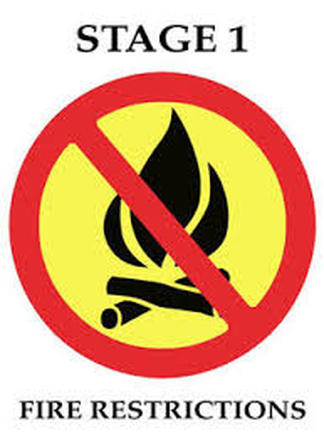
Yosemite National Park is experiencing high fire danger, along with continued hot and dry weather patterns. Due to the current and predicted fire conditions and fire behavior, the Superintendent of Yosemite National Park will be implementing Stage 1 fire restrictions until further notice is given.
By order of the Superintendent of Yosemite National Park and under authority of Title 36, Code of Federal Regulations, Section 2.13(c):
· No building, maintaining, attending or using a fire, campfire, or cooking fire (including charcoal fires) within Yosemite National Park below 6,000 feet in elevation. “Sierra” (twig) stoves are not permitted. Portable stoves using pressurized gas, liquid fuel or propane are permitted, as are alcohol stoves (with and without a shutoff valve) including alcohol tablet/cube stoves.
· No smoking below 6,000 feet except within an enclosed vehicle, a campground or picnic area where wood and charcoal fires are allowed or in a designated smoking area. All public buildings, public areas of Concession buildings (including restrooms), other areas as posted and within 25 feet of any non-single family residential building remain closed to smoking at all times.
· Campfires and cooking fires may still be used in designated campgrounds, picnic areas and residential areas in developed portions of the park in accordance with park regulations.
Designated Campgrounds and Picnic Areas: Upper Pines, Lower Pines, North Pines, Yellow Pines, Camp 4, Wawona, Bridalveil Creek, Hodgdon Meadow, Crane Flat, Tamarack Flat, White Wolf, Yosemite Creek, Porcupine Flat, Tuolumne Meadows., Lembert Dome, Tenaya Lake, Yosemite Creek, Wawona, Mariposa Grove, Glacier Point, Cascade, El Capitan, Cathedral Beach, Sentinel Beach, Swinging Bridge, Housekeeping Camp, Church Bowl, and Lower Yosemite Falls.
There are no administrative exemptions to this order. Notice of closure will be posted and areas will be monitored to ensure compliance. This designation will remain in place until rescinded.
--
Yosemite Fire and Aviation Information
[email protected]
209-379-1493
YARTS Suspends Service
Effective 7/25/18, all YARTS service to Yosemite Valley is suspended until further notice.
YARTS will operate on the following schedule on July 25, 2018:
HWY 41 (FRESNO)
Runs 22, 24 & 26 will arrive in Yosemite Valley by 10 am with no passengers.
Run 22 will depart Yosemite Valley Visitor center at 10:30 am
Run 24 will depart Yosemite Valley Visitor center at 11 a.m.
Run 26 will depart Yosemite Valley visitor center at 11:30 am.
THESE WILL BE THE ONLY BUSES LEAVING YOSEMITE VALLEY FOR HWY 41 DESTINATIONS UNTIL FURTHER NOTICE.
HWY 395/120E (MAMMOTH LAKES)
Buses will depart as scheduled with the only destination being Tuolumne Meadows until further notice. Buses will hold in Tuolumne Meadows and return at the scheduled times.
HWY 120 W (SONORA)
Runs 1, 2 & 3 will arrive in Yosemite Valley by 10 am with no passengers.
Run 1 will depart Yosemite Valley Visitor Center at 10:20 am
Run 2 will depart Yosemite Valley Visitor center at 10:50 am
Run 3 will depart Yosemite Valley Visitor center at 11:20 am.
Two additional buses will arrive at Yosemite Valley Visitor Center by 11a.m. to take passengers going to MERCED only. Those buses will depart Yosemite Valley Visitor Center at 11:25 am for Merced.
THESE WILL BE THE ONLY BUSES LEAVING YOSEMITE VALLEY FOR HWY 120 W DESTINATIONS or MERCED UNTIL FURTHER NOTICE.
HWY 140 (MERCED/MARIPOSA)
Will continue to operate on its modified schedule until further notice.
Portions Of Yosemite National Park To Close Until Sunday, July 29, Ahead Of Ferguson Fire
Posted by: gina clugston July 24, 2018 - 1:11 pm
YOSEMITE – Yosemite National Park officials have announced that parts of the park will be closed as the nearly 37,000 acre Ferguson Fire moves ever-eastward toward Highway 41 and the communities of Wawona and Yosemite West.
Yosemite Valley and Wawona will close at noon tomorrow, July 25, to all visitors due to the ongoing impacts of the fire.
These closures include all hotels, campgrounds and visitor services in Yosemite Valley and Wawona. Park visitors currently staying in park campgrounds and lodging facilities are asked to be out of these areas by noon tomorrow. There is no fire in the vicinity of Wawona, but Rte. 41 will need to be used exclusively by fire personnel for containment and back-burning.
With the ongoing closure of Highway 140, park visitors can exit the park via Highways 120 and 41. The temporary closure is expected to last until Sunday, July 29. The Mariposa Grove of Giant Sequoias is closed.
Since the fire began on Friday, July 13, several other park facilities and roads have been closed due to fire impacts and the need to support firefighting operations. These closures include the Glacier Point Road, Bridalveil Creek Campground, the Wawona Campground, the Merced Grove of Giant Sequoias and others.
Highways 120 west and east, and the Tuolumne Meadows area remain open at this time.
The park will continue to work with the Incident Management Team and assess conditions day by day.
For updated 24-hour road and weather conditions for Yosemite National Park, please call 209-372-0200, press 1 and press 1 again. Updated information is also available on the park’s website at www.nps.gov/yose.
New Meeting For Wawona Regarding Ferguson Fire
There will be another community meeting Wed., July 25, at 3pm at the Community Center again presented by the IMT, to brief everybody about current preparations for various contingencies in the Wawona/ Hwy. 41 area.
Ferguson Fire Perimeter Map, July 24
Note increase in black line (containment @ 25%), and dozers lines near Wawona.
Ferguson Fire 25% Contained
Sierra Sun Times, July 24, 2018 - Awahanee, CA. -
The Ferguson Fire now in its 12th day, started July 13 on the Sierra National Forest and is managed under unified command between the United States Forest Service, California Interagency Incident Management Team 4, CALFIRE and the Mariposa County Sheriff’s Office. Much of the fire is burning in steep, rugged terrain with little to no access roads. Mandatory and advisory evacuations are in place in several areas but no homes have been damaged or destroyed.
The Ferguson Fire is burning in very rough terrain with high firefighter exposure due to very hot conditions and limited access requiring heavy rotor wing support. Prior to the Rough Fire, this river canyon held the record for the largest fire on the Sierra NF which burned in 1924.
Yosemite National Park remains open, nps.gov/yose or call 209-372-0200
The fire is 36,587 acres with 25% containment. 3,311 personnel are currently engaged on the fire which includes 194 engines, 45 water tenders, 16 helicopters, 91 crews, and 52 dozers. There has been 1 fatality and 6 injuries to date.
Today at 11:00 a.m., the Unified Commanders, CAL FIRE, US Forest Service and Mariposa County Sheriff’s Office, will host a community meeting to discuss the current Ferguson Fire situation. Officials will present an overview of the current status of the fire and actions being taken to stop its spread. Current maps of the fire will be available, as well as other handouts. Officials will be available to answer questions. Meeting will take place at the Yosemite Valley Auditorium 9035 Village Drive Yosemite National Park, CA 95389. Parking is available along Village Drive or in the Yosemite Village Parking Area.
Ferguson Fire Containment Jumps, One Structure Destroyed
Written by Tracey Petersen.
Update at 7:15 a.m., July 23: Incident Command relays that one outbuilding has been destroyed but stress “dozens more have been saved because of the efforts of crews throughout the fire area.” This weekend the threat to structures surged from 216 to 3,494 after a mandatory evacuation order was issued for Old Yosemite Road in the Groveland.
New help in the skies to battle the blaze are a pair of DC-10 tanker planes and a fleet of helicopters, which are being utilized to slow the fire’s spread. To the south, the fire continues to burn in the Chowchilla area and indirect-line construction is moving forward to protect Wawona and Yosemite National Park.
Firefighters are making good progress building lines to help contain the blaze as they gained 13% contained overnight the total acres is 33,743 acres.
Additional details on the fire and a Celebration for Life for a fallen firefighter are below.
Original post at 6:30 a.m.: Mariposa, CA — The latest update on the Ferguson Fire, burning on both the Sierra and Stanislaus national forests, overnight the acreage rose by nearly 1,300 acres to a total of 33,743 acres, but some good news this morning the containment rose to 13-percent. However, the threat to structures surged from 216 to 3,494 this weekend. The explosion in the number came with the afternoon mandatory evacuation order for Old Yosemite Road in the Groveland area as the fire moved north toward the Montgomery Gulch and Anderson Valley vicinities.
Another two firefighters were injured battling the blaze bringing the total to six, as reported hereyesterday. Fire spokesman Rich Eagan says the firefighters were hospitalized Friday after suffering back injuries. Both have been released and are expected to fully recover. Two of the other four firefighters also had back injuries involving muscle strain, another one suffered from a leg fracture and the other from dehydration.
Honoring a fallen firefighter, a public visitation was held yesterday in Modesto for fallen Heavy Fire Equipment Operator Braden Varney. Today there will be a Celebration of Life, also in Modesto, at the House Church located at 1601 Coffee Road it begins at 10:30 a.m.
Overnight, ground crews worked preparing for firing operation along several fronts of the blaze including east on Henness Ridge, near El Portal southeast toward Wawona Road and Yosemite National Park to take place when weather conditions improve.
Resources on scene include 3,066 personnel, 199 engines, 46 water tenders, 16 helicopters, 66 hand crews and 43 dozers.
If you see breaking news, traffic or weather contact us at the News Hotline at 532-6397. If you have a photo regarding this news story or any Mother Lode News Story please email [email protected].
Fire information is located under the “Community” tab or keyword: fire
Local Burn Day information is here. If you see breaking news send us a photo at [email protected].
