WawonaNews.com - July 2014
Wildfire Near Yosemite Forces Road Closures, Evacuations
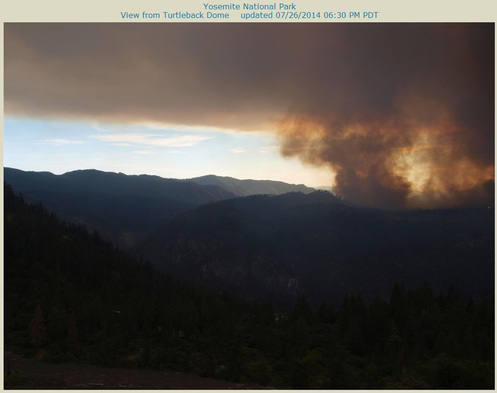
July 26, 2014
Evacuations are in place for the community of Foresta as firefighters battle a wildfire outside Yosemite National Park.
The fire started Saturday around 4:30 p.m. and now covers approximately 500 acres.
It is burning in the Merced Canyon, and has been named the “El Portal Fire.”
The closure of Highway 120, between Crane Flat and the Highway 120/140 junction has been ordered. The community of Foresta has been ordered evacuated.
Many resources have been ordered to attack the fire: ground crews, air craft, and helicopters. More resources will arrive throughout the evening.
Yosemite July Lightning Fire Update #1 - 7/24/14
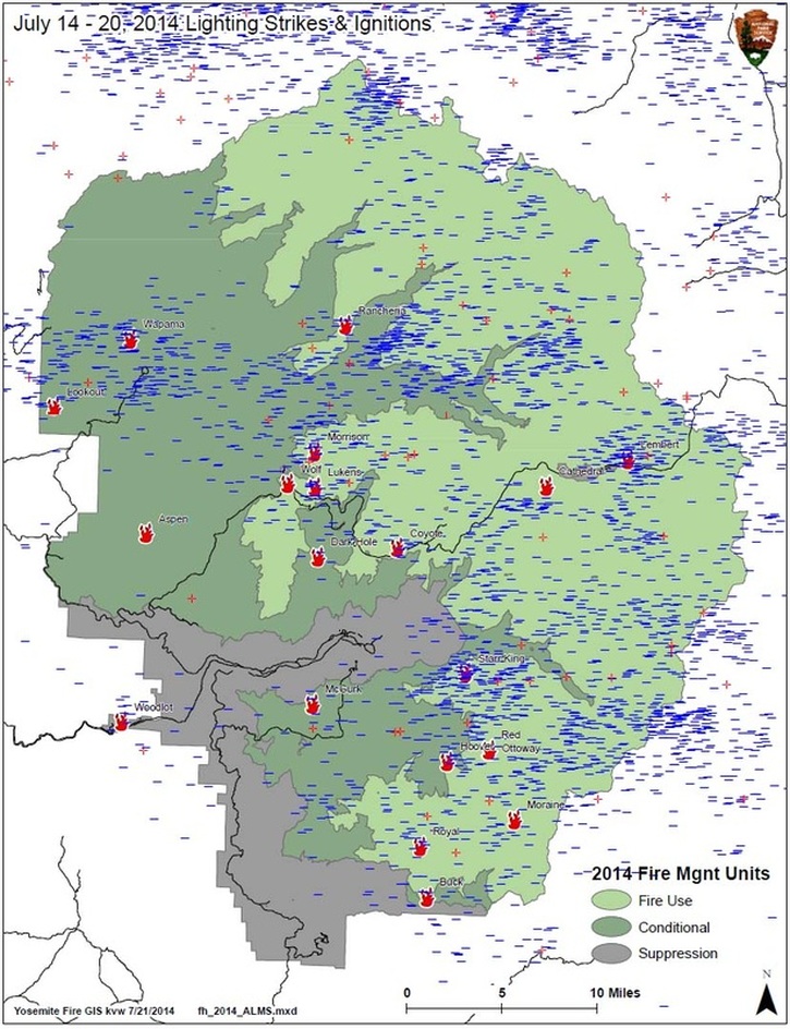
Since July 14, Yosemite National Park has experienced over 3,000 lightning strikes with more than 21 fire starts. Multiple thunderstorms, accompanied by rain, have put out or temporarily slowed activity and growth. Most fires are between 8000’ and 9000’ elevation. They are small, creeping and smoldering surface fires or single logs less than 1/10 of an acre and are showing minimal activity. Of 1,004 fires above 8,000’ since 1930, 941 never got to be 10 acres. Most of these fires have few values at risk an pose little threat to people or park infrastructure. As the weather warms and fuels dry out it is likely other fires will be found. All fires are being monitored by fire crews.
Fires Managed for Multiple Objectives: Yosemite fire management is developing strategies for these fires and depending on risk assessment; most of these current fires will be naturally extinguished. Fire crews will utilize natural barriers of granite, streams or open ground to manage fires. The Fire Management Plan allows the park to manage any fire outside of the suppression unit.
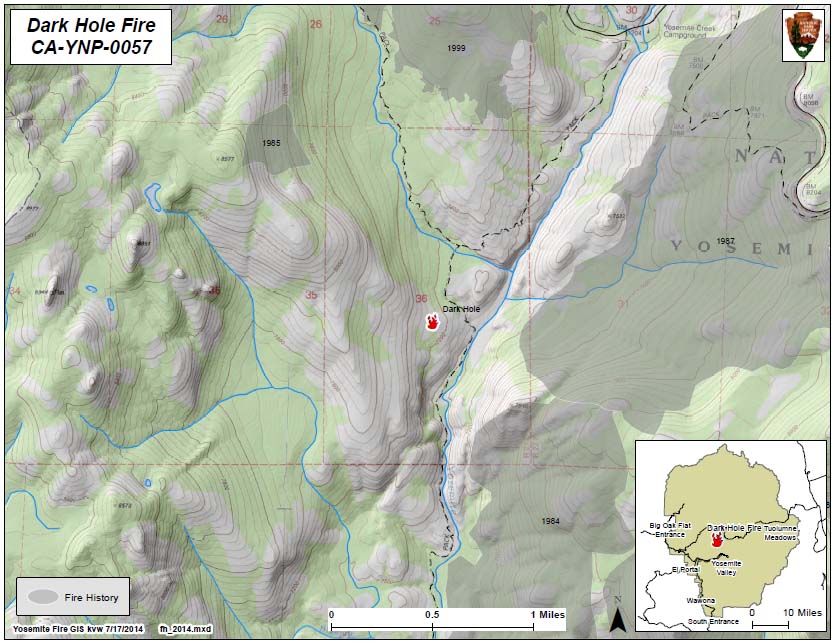
Dark Hole: (37 48.323 x 119 36.786, Mariposa Co. 7400’, July 16.) This fire has grown to approximately 11 acres and will be managed for multiple objectives. It is within a red fir forest and it is the largest and most active of all the park-wide fires. It is located near the Yosemite Creek trail about a mile south of the Yosemite Creek campground. It is in an area of past lightning fires, although the immediate area has no fire history. Smoke is visible from Tioga Road east of Yosemite Creek, and from Sentinel Dome and Glacier Point. Hazards may include smoky conditions and poor visibility, rolling rocks and logs. There is one trail closure: The Lukens trail to Yosemite Creek trail is closed between Tioga Road and Yosemite Creek Campground Road and Trail. The Yosemite Creek Tail remains open. To avoid smoke and other hazards, hikers are urged to pass through the area quickly.
Lukens: (37 51.514 x 119 37.080, Tuolumne Co., 8310’, July 15) A single log is burning within a red fir forest near Lukens Lake.
Morrison (37 53.117x119 37.153 - Tuolumne Co., 8740’ July 15) This is a surface fire smoldering and creeping through forest needle litter in a red fir forest.
Starr King (37 43.215x119 28.108 Mariposa Co., 8730’, July 16) This is on the east side of Mount Starr King. It is creeping and smoldering through red fir. It is periodically visible from Washburn Point.
Cathedral (37 51.843x119 23.720 – Tuolumne Co. 9140’, July 16) This high elevation fire is smoldering in a single log. It is west of Cathedral Peak.
Lembert (37 53.159x119 19.059 – Tuolumne Co. 9250’, July 16) This smoldering and creeping surface fire is east of Lembert Dome in a lodgepole pine forest. It is has not been active, is not visible and may be out.
Moraine (37 37.195x119 25.126 – Madera Co. 9480’, July 14) This high elevation fire in red fir is not showing any activity.
Coyote (37 48.53 x 119 32.26 - Mariposa Co. 9000’ Start July 19). This was a single snag in granite. It has low potential to grow.
Wolf (37 51.644 x 119 38.684 – Tuolumne Co. 8200’ July 17) This is a surface fire showing little fire activity in red fir & lodgepole pine.
Rancheria (59.014 x 119 335.625 - Tuolumne Co. 8200’July 19) This remote fire, north of the Hetch Hetchy Reservoir, remains active and is .25 acre in size. It is within a Jeffrey pine, lodgepole pine forest. It has moderate to high potential for growth and is within the 1948 Rancheria Fire footprint.
Wapama (37 58.134 x 119 44.983 – Tuolumne Co. 5530’ July 19) This fire is at the top of Wapama Falls on the north Rim of Hetch Hetchy Reservoir. It is active and at .25 acre in Jeffrey pine and live oak.
Royal (37 39.232 x 119 30.452 – Madera Co. 9000’, July 20) A single tree was struck by lightning and the smoldering fire is surrounded by granite. It is south of Glacier Point.
Red (37 39.71 x 119 26.67 – Madera Co. 8030’, July 20) A single tree was struck and it has low potential for growth. This fire is near Red Peak within the Illilouette basin, south of Glacier Point.
McGurk (37 41.589 x 119 36.884 – Mariposa Co. 7020’, July 20) The top of a White Fir tree was struck by lightning. The strike tree is at the top of Bridalveil Falls on the south rim of Yosemite Valley. The smoldering fire is not showing fire activity.
Falls (37 59.358 X 119 45.022 – Tuolumne Co. 6160’, July 20) This fire is near the north rim of Hetch Hetchy Reservoir. It remains active.
Gibson (37 59.466 X 119 44.440 – Tuolumne Co. 6450, July 20) This fire is between Falls Creek and Mt. Gibson on the north rim of Hetch Hetchy and surrounded by granite. It remains active in black oak & Sierra juniper.
Lookout (37 38.98 x 119 28.734 – Tuolumne Co. 5,200’ July 20) This fire is near the North Mountain fire lookout. This fire is within the Rim Fire footprint in a ponderosa pine forest. This fire is showing little activity.
Lightning Fires Identified for Suppression: These fires either at high elevation or threatened communities. These fires will continue to be patrolled by fire crews:
Woodlot (37 40.527x119 47.835 – Mariposa Co., 2050’ July 20.) This fire had high potential to grow and threatened the community of El Portal. Quick initial actions by fire crews kept this fire to less than 4 acres. Fire crews will continue to patrol the area.
Buck (37 32.914 x 119 29.982 – Madera Co. 7920’ July 20) A single tree was struck near the southern park boundary at the upper end of the South Fork Merced River. It was in a red fir forest. This fire was put out by Yosemite Helitack crews.
Aspen (37 49.165 x 119 46.758 – Tuolumne Co., 6280’, July 15). This fire is within the 2013 Rim Fire footprint and near Aspen Valley. A single ponderosa tree was burning. The fire tree was lined to mineral earth by fire crews and is reported out.
Hoover (37 39.143 x 119 29.018 – Mariposa Co. 8030’, July 20) This fire is south of Glacier Point and in the Illilouette basin. It is within the 2001 Hoover Fire footprint. It is in heavy brush fields. Yosemite Helitack crews have lined and contained the creeping and smoldering fire and it will be suppressed.
Ottoway (37 39.705 x 119 26.622 – Mariposa Co. 8880’, July 20) It was found very near the Hoover Fire footprint. Fire crews reported it out.
For additional information:
Ø Fire Information: [email protected]; (209) 372-0480 or (209) 375-9574.
Ø Yosemite National Park Web Page: http://www.nps.gov/yose/parkmgmt/current_fire.htm.
Ø Yosemite Air Quality Web Page: http://www.nps.gov/yose/naturescience/aqmonitoring.htm
Ø Yosemite Fire Facebook: http://www.facebook.com/pages/Yosemite-Wildland-Fire/124632964255295
Ø Yosemite Fire Twitter: http://twitter.com#!/YosemiteFire
YOSEMITE-WAWONA ELEMENTARY SCHOOL
Board of Directors Meeting
Board of Directors Meeting
Monday, July 14, 2014
Wawona Elementary School
7925 Chilnualna Falls Road
Wawona, California
Amended
CALL TO ORDER at 6pm.
ROLL CALL
Members Present:
Michelle Stauffer Ed Mee
Max Stauffer Dale Wohlgemuth
Chad Andrews Stella Pizelo
Staff present:
Esme Macarthy
Public present:
INTRODUCTIONS
APPROVAL OF MINUTES from June 7, 2014 meeting.
PUBLIC COMMENTS ON NON-AGENDA ITEMS. Note: The public may speak on any item not on the printed agenda. No action may be taken by the Board. The public will also be given the opportunity to comment before or during the Board’s consideration of items.
CONSENT AGENDA
Approve expending $78.92 to repair playground equipment.
Approve expending $1388.54 To CRMA for Liability insurance.
Approve expending $572.00 to CRMA for Workers Comp insurance quarterly premium.
Approve expending $20 for State Raffle Yearly Registration.
Approve reimbursing Chad Andrews $26.89 for supplies to repair retaining wall.
PRESIDENT’S REPORT
Business management.
FINANCIAL REPORT
BOARD REPORTS
STAFF REPORTS
DISCUSSIONS/ACTION ITEMS
Recycling Center repairs and upgrades.
Computer equipment purchase for students.
NEXT MEETING DATE
NEXT MEETING AGENDA ITEMS
ADJOURNMENT
South Fork continuing to drop at exceptionally fast rate
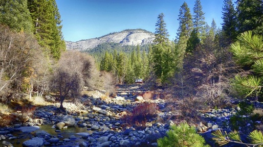
Dear Yosemite Community: Yosemite is now entering its third consecutive year of drought. After an exceptionally dry winter and spring, water in the South Fork Merced and Tuolumne rivers are continuing to drop at exceptionally fast rates and our driest and busiest months are still to come. The South Fork has now dropped to 2.78 CFS, and we are implementing critical water conservation measures.
Past droughts have shown domestic water supply in Wawona and Tuolumne to be especially vulnerable. Previous water conservation efforts in Wawona have had significant effects on water usage. Thanks to water conservation effort water use in Wawona dropped daily average of 77,523 gallons in June 2013 to 69,596 gallons in June 2014. Although Wawona and Tuolumne are the most highly impacted communities by the drought, the severity and duration of this drought makes water usage a responsibility for every member of Yosemite.
Some key water conservation measures to remember:
*Ensure faucets, toilet, pipes, and other water sources do not leak.
*Take shorter showers and install water-saving shower heads or flow restrictors.
*Don’t let the water run when brushing your teeth or shaving, use a wash basin.
*Don’t let the faucet run while preparing food or cleaning, and use your automatic washing-machine only for full loads.
*Use a broom to clean driveways, sidewalks, and steps, and don’t run the hose while washing your car.
Water your lawn only when it needs it, do so when cool and avoid watering on windy days.
For a complete list of conservation measures, refer to appendix B in the Wawona Water Conservation Plan. If you have any questions, contact District Ranger Eric Scott at: 209-375-9520. We thank you for your continued attention to this very timely and important issue. We will continue to update you as we learn new information about this drought and how to best protect the water ecosystems of Yosemite National Park.
On behalf of the Executive Leadership Team,
Don Neubacher
New Yosemite Nature Notes Video: Birdsongs
_YOSEMITE-WAWONA ELEMENTARY CHARTER SCHOOL
Board of Directors Meeting

Board of Directors Meeting
Monday July, 2014
Call to Order 6 p.m.
Introductions
Public comments on non-agenda items. Note; The public may speak on any item not on the printed agenda. No action may be taken by the Committee. The public will also be given the opportunity to comment before or during the committee’s consideration of items.
Approval of June 29, 2014 Meeting Minutes
President’s Report
Financial Report
Board Reports
Discussions/Action Items
Authorize official name change
Recycling Program
Insurance Resolution
Next meeting; date and agenda
Adjournment
In compliance with the American Disabilities Act, if you need special assistance to participate in this meeting, please contact the Wawona School at 209-375-6383.
Yosemite National Park: Protected for 150 Years
By Rob Lovitt
On June 30, 1864, President Abraham Lincoln took time out from the trauma and bloodshed of the Civil War to sign legislation to preserve two parcels of land in Mariposa County, California. Known as the Yosemite Grant, it didn’t just save the land from commercial development; it also laid the foundation for what we know as national parks today.
“Setting aside special places for all people for all time had never been done before,” said Mike Tollefson, president of the Yosemite Conservancy, the park’s philanthropic partner. “It launched the national park idea, not only in this country but worldwide.”
On Monday, the park will celebrate that 150-year legacy with a full schedule of events, including a heritage fair, museum exhibits and history hikes with “Galen Clark,” an early settler and the park’s first ranger. Bringing the festivities full circle will be a groundbreaking ceremony for the restoration of the park’s Mariposa Grove, which along with Yosemite Valley was originally preserved 150 years ago.
YOSEMITE-WAWONA ELEMENTARY CHARTER SCHOOL
Board of Directors Meeting
Sunday June 29, 2014
1. Call to Order 7 p.m.
2. Introductions
3. Public comments on non-agenda items. Note; The public may speak on any item not on the printed agenda. No action may be taken by the Committee. The public will also be given the opportunity to comment before or during the committee’s consideration of items.
4. President’s Report
5. Financial Report
6. Board Reports
7. Discussions/Action Items
a. Approve Bylaws and Conflict of Interest
b. Approve Articles of Incorporation
c. Approve Non-Material changes to Charter
d. Review and Approve LCAP
e. Review and approve Insurance Contract with CMRA
8. Next meeting: date and agenda
9. Adjournment
In compliance with the American Disabilities Act, if you need special assistance to participate in this meeting, please contact the Wawona School at 209-375-6383.
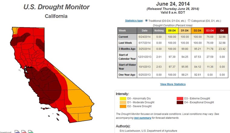
California Drought Map for June 24, 2014 Shows 76% of the State in Extreme Drought
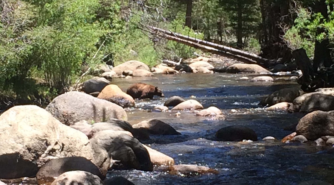
Bear sighting on Buckeye Creek
Wawona Water Conservation
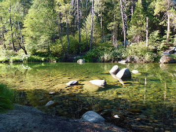
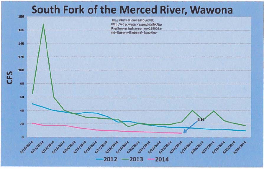
This winter and spring have been exceptionally mild with regard to rain and snowfall. Like 2012 and 2013, 2014 will likely go down as one of the driest years on record for Yosemite National Park. As a result, water levels in the rivers and streams are lowfor June. Current data shows that the water level in the South Fork Merced River is dropping quickly and there is no significant precipitation forecasted in the near future. Water conservation measures are mandatory when flow rates drop below 6 cubic feet per second (CFS) in the South Fork Merced.
As of June 23, the river-gauge has measured below 7 CFS (see chart below) which means that the Wawona community will soon need to implement conservation measures. We anticipate that the South Fork Merced will remain below these levels until significant rainfall occurs. We ask that residents and employees begin implementing the guidance and direction from water conservation plan. There is also a list of recommended measures below. Attentive conservation measures are our best approach to ensure that water is available where needed for safety and health purposes, as well as protection of park resources.
We ask that you consider your water consumption in the coming days and weeks and look for ways to conserve it. We will continue to share more information about the water levels and conservation practices as necessary. We thank you for your attention and support as we address this important community issue. Through our combined efforts, we can work to maintain a sufficient water supply while still preserving the ecosystems of Yosemite National Park. (J. Friesen-McCabe)
Black Bear follows joggers in Canada
Two men jogging on the Matcheetawin Discovey Trails near Fort McMurray, Alta., earlier this month got quite a scare after a close encounter with a black bear.
Bruce Allan posted a video of the encounter on YouTube.
In the video, which was filmed on June 5, the bear follows the joggers for several minutes, coming extremely close but never attacking.
"You have to let us go," urged one of the people in the video.
The bear eventually appeared to lose interest and the joggers sprinted to their vehicle and out of harms way.
