WawonaNews.com - October 2014
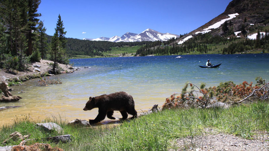
Scenes from Tenaya Lake
Your browser does not support viewing this document. Click here to download the document.
Innkeepers plan attack on tax hike
By Erik Skindrud
MARIPOSA GAZETTE EDITOR
A group of innkeepers met last week to organize opposition to Measure K, the ballot measure that would raise the pernight tax on tourists from 10 percent to 11.25 percent.
Raising the tax would hammer lodging operators by upping the price of county stays compared to adjacent counties, said Kevin Shelton, a spokesman for the county’s second-biggest lodging operator.
“Today, people book online, and they can instantly compare rates,” Shelton said. “That ability requires us to make sure our rates are competitive. Any increase (in bed tax) challenges our competitiveness.”
A simple majority of voters must back Measure K on Nov. 4 for it to take effect next year. Raising the tax, which applies only to visitors, might put tens of thousands of more dollars in the county’s general fund and could reduce the chance that future wildfires or government shutdowns would spur layoffs or furloughs for county employees, proponents say.
Former County Administrative Officer Rick Benson, who left the position earlier this month, recommended the increase to the board. Supervisors Kevin Cann, Merlin Jones, Janet Bibby and Lee Stetson passed the item with yes votes on July 8.
Supervisor John Carrier cast the lone no vote.
Among the lodging operators who met on Sept. 18 were Shelton, of Yosemite View Lodge and Cedar Lodge, Douglas Shaw of the Yosemite Bug Rustic Mountain Resort, Gopal Das of Mariposa’s Comfort Inn and Donna Davis of The Redwoods in Yosemite (located at Wawona), said Gary Francisco, a Midpines vacation-rental owner who also attended the meeting.
Attendees discussed the possibility of printing “No On Measure K” signs at the meeting, but no course of action was agreed upon, Francisco said.
Francisco called the notion that the increase is needed “doom and gloom” on the part of outgoing CAO Benson.
“(My) observation (is), the cost of government will always rise to the amount of money given it,” he said in an email.
Davis, who helps manage more than 130 vacation rentals inside the Park at Wawona, said the tax hike might have far-reaching effects if voters approve it.
After paying more for lodging, visitors might be stingier with their money at shops and restaurants. The tax hike might hit group lodging in shoulder seasons especially hard, she said.
Ultimately, nudging bed-tax up might actually reduce the county’s tax revenue, because visitors would end up going elsewhere, she argued.
“I’m going to do everything in my power to make sure voters understand how harmful this could be to the county’s budget,” she said. “And we only have a couple of weeks to get our message out.”
The Nov. 4 election is a little over a month away. Sample ballots were due to be mailed today from the county elections office, Registrar of Voters Keith Williams said on Monday.
Vote-by-mail ballots are scheduled to go out on Monday, Oct. 6, Williams said, so some voters might be making their choices as early as Tuesday.
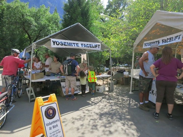
Yosemite Facelift 2014
Your browser does not support viewing this document. Click here to download the document.
Your browser does not support viewing this document. Click here to download the document.
New Program Tracks Yosemite’s Bears in Real-Time
National Park Service Programs and Yosemite Conservancy Funding Help Keep Bears Wild
Yosemite National Park, Sept. 23, 2014 – For the first time, National Park Service wildlife managers in Yosemite will map and monitor the movement of the park’s black bears in real-time to help wildlife managers understand the animals’ activities beyond Yosemite Valley. Yosemite Conservancy donors are contributing nearly $70,000 to purchase GPS collars to track the bears.
The project will provide currently unknown information about how bears are using the majority of the park’s wild habitat. Wildlife managers have successfully tracked the movements of black bears in developed areas in Yosemite for over a decade using radio telemetry. However, once a bear leaves a developed area, its movements are difficult to track.
“This project will expand the park’s understanding of Yosemite’s black bear population, and help to keep bears wild and visitors safe,” said Yosemite National Park Superintendent Don Neubacher. “Yosemite Conservancy funding helps us to achieve our bear management goals of keeping healthy natural populations of black bears as independent from human influence as possible.” Neubacher added that study results would be used as part of interpretive programs to teach visitors about bears’ behavior.
The full breadth of the park’s bear management programs, many of which are supported by Yosemite Conservancy, have reduced bear incidents involving damage to personal property by 95 percent since 1998, according to the National Park Service. Since 1989, Yosemite Conservancy donors have contributed $2.1 million to support bear protection and education programs, such as the construction and installation of over 2,000 bear-proof food storage lockers throughout the park. The organization also rents bear-proof food canisters used by backpackers and supports educational programs like the Junior Ranger program, an interactive program that helps children develop an appreciation for protecting natural resources by teaching them about park wildlife, habitat and history. The National Park Service’s “Red Bear-Dead Bear” signs mark sites where bears have been hit by vehicles to encourage drivers to slow down.
“We’re committed to helping the park protect Yosemite’s wildlife so future generations can experience thrills like seeing a black bear ambling through a valley meadow,” said Yosemite Conservancy President Mike Tollefson. “Those are memories that last a lifetime and encourage people to be stewards of the park.”
Tollefson said the GPS technology to be used in the bear program has been applied successfully in an effort funded by Yosemite Conservancy to reestablish and monitor bighorn sheep in Yosemite. The new GPS program for bears and existing radio telemetry tracking allow park personnel to prevent incidents and help stem bears’ reliance on human food sources. Bears that become conditioned to human food stored or disposed of improperly often break into vehicles and even homes.
Through the support of donors, Yosemite Conservancy provides grants and support to Yosemite National Park to help preserve and protect Yosemite today and for future generations. The work funded by Yosemite Conservancy is visible throughout the park, from trail rehabilitation to wildlife protection and habitat restoration. The Conservancy is dedicated to enhancing the visitor experience and providing a deeper connection to the park through outdoor programs, volunteering and wilderness services. Thanks to dedicated supporters, the Conservancy has provided more than $81 million in grants to Yosemite National Park. Learn more at www.yosemiteconservancy.org or call 1-800-469-7275. Additional details on bear management are also at http://www.nps.gov/yose/naturescience/bear-management.htm.
-NPS-
Editor’s Note: Photos are available by e-mailing Peter Bartelme at [email protected] or calling at 415-664-1503
Contacts:
Peter Bartelme, Yosemite Conservancy, 415-664-1503, [email protected]
Jennifer Miller, Yosemite Conservancy, 415-434-1782, [email protected]
Scott Gediman and Kari Cobb, National Park Service, 209-372-0248, [email protected], [email protected]
YOSEMITE-WAWONA ELEMENTARY CHARTER SCHOOL Board of Directors Meeting

September 24, 2014, 6 PM
Wawona Elementary School
7925 Chilnualna Falls Road
Wawona, California
AGENDA
1. CALL TO ORDER
2. ROLL CALL
MONTHLY ITEMS AND FINANCIAL REPORTS
3. CONSENT AGENDA
NOTE: The Board will be asked to approve all of the following items by a single vote, unless any member of the Board or of the public asks that an item be removed from the consent agenda and considered and discussed separately.
3.1. Approval of agenda
3.2. Approval of minutes of the regular meeting, September 15, 2014
4. Financial reports
4.1. Monthly approval of warrants (Action needed)
4.1.1. Reimbursement to Esme for Office Supplies
4.2. Financial Report
5. HEARING OF PERSONS WISHING TO ADDRESS THE BOARD
The public may address the Board on any matter pertaining to the school that is not on the agenda. Unless otherwise determined by the Board, each person is limited to five (5) minutes. There will be no Board discussion and no action will be taken unless listed on a subsequent agenda.
ACTION ITEMS
6. Discuss and approve new Board members
7. Discuss and approve procedure to receive wire transfers and certificate form for funding from the State
8. Establish reporting procedures for Attendance Report
9. Discuss Loretta teaching one day a week. Approve funding.
Your browser does not support viewing this document. Click here to download the document.
Your browser does not support viewing this document. Click here to download the document.
Your browser does not support viewing this document. Click here to download the document.
Your browser does not support viewing this document. Click here to download the document.
Your browser does not support viewing this document. Click here to download the document.
Golf tournament on Saturday, September 20

Join the Yosemite Wawona Elementary Charter School for a BBQ dinner after the school golf tournament on Saturday, September 20. 4 p.m. on the hotel lawn.
Check out the Silent Auction and Raffle prizes. They are great this year!!
Dinner Menu: (Adults $20 & Children $10)
Wawona BBQ Dinner Serve: 4:00 PM to 6:00 PM
CHOICE OF ONE ENTREE ENTREE: Baby Back Ribs, Half Rack, House BBQ Sauce ENTREE: Flat Iron Steak, 8 oz. Spice Rubbed ENTREE: BBQ Chicken, Half Chicken, House BBQ Sauce ENTREE: Garden Burger, Grilled Vegetarian Patty SIDES (UNLIMITED): BBQ Baked Beans, Corn on the Cob, Cornbread, Coleslaw, Potato Salad, Pasta Salad & Garden Salad DESSERTS: Cakes, Pies & Fresh Fruit BEVERAGES: Iced Tea, Lemonade, Coffee & Ice Water
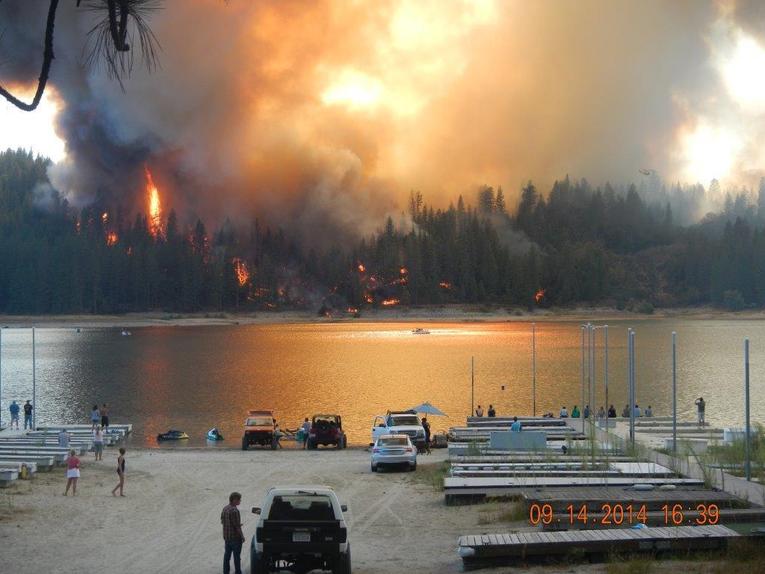
Courtney fire now 60% contained
Courtney Fire Incident Information:
Last Updated: September 17, 2014 8:20 am
Date/Time Started: September 14, 2014 1:36 pm
Administrative Unit: CAL FIRE Madera-Mariposa-Merced Unit
County: Madera County Location: Courtney Lane and 7 Hills Rd, Oakhurst
Acres Burned - Containment: 320 acres - 60% contained
Structures Destroyed:33 Residences, 28 Outbuildings, 13 Vehicles and 4 Recreational Vehicles Destroyed and 4 Residences, 6 Outbuildings and 2 Vehicles Damaged
Evacuations: 200 Structures with approximately 600 residents living in the Bass Lake Heights community.
****Effective September 16, 2014 at 6:00 PM the Evacuation Order is lifted for the residents along Summit Road.
Road Closures :Road 426 between Suncrest Drive to Road 223
Road 222 between Road 432 (Rec Point) and Road 426 Road 426 between 222 and
Injuries: 2 Cause: Under Investigation Cooperating
Agencies: CAL FIRE, USFS, CAL OES, Madera County Fire Department, Madera County Sheriff’s Department, PG&E, Red Cross, Sierra Telephone, CHP, Hillview Water District, and Local Government Resources within the Central Valley.
Total Fire Personnel: 560
Total Fire Engines: 73
Total Fire crews: 10
Total Dozers: 8
Total Water Tenders: 11
Long/Lat: -119.604124/37.311915
Conditions: Firefighters are continuing to build and reinforce containment lines. There continues to be a threat to the Bass Lake Heights community. Access to the fire is difficult due to steep terrain and several structures in the Wildland Urban Interface. Firefighters are experiencing extreme fire behavior conditions due to drought and low fuel moisture. Over 35 residents were escorted through the fire damaged area.
Phone Numbers (209) 966-4784 (Courtney Fire Information Line)
Your browser does not support viewing this document. Click here to download the document.
Your browser does not support viewing this document. Click here to download the document.
Courtney Fire Update - 8 AM, September 16
Courtney Fire (Madera County, Central California) Update:Latest Statistics: 320 Acres Burned, 61 Structures Destroyed, 35 Percent Contained
Evacuations remain in place for 600 people in 200 homes in Madera County due to the Courtney Fire. The fire spread from Oakhurst, California, to the popular recreational area Bass Lake. More than 600 firefighters were struggling to cope with the blaze due to steep, rugged terrain and "extreme fire behavior conditions."
The fire already claimed 61 structures, including 33 homes, near Oakhurst, California, an area already reeling from a wildfire that destroyed eight structures earlier this year.
"I really feel for this community, which has already been through a lot," state fire spokesman Dennis Mathisen told the Associated Press. "This is yet another example of how the damaging effect of this drought has impacted California."
Your browser does not support viewing this document. Click here to download the document.
Your browser does not support viewing this document. Click here to download the document.
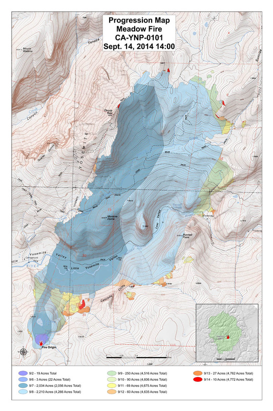
Meadow Fire 80% Contained
Basic Information
Current as of: 9/15/2014, 8:20:47 AM
Incident Type: WildfireCauseLightning
Date of Origin: Saturday July 19th, 2014 approx. 08:00 AM
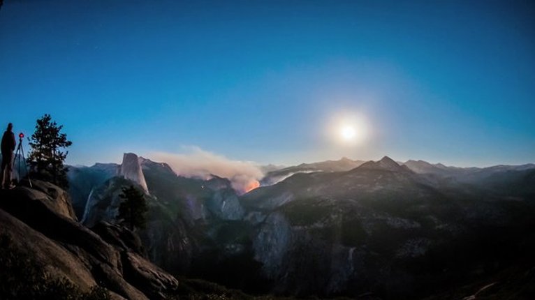
Location: East of Half Dome in the Merced River Drainage at Little Yosemite Valley
Incident Commander: David Cooper
SCSIIMT2Incident Description: Wildfire In The WildernessCurrent Situation
Total Personnel: 424
Size: 4,772 Acres
Percent of Perimeter Contained: 80%
Estimated Containment Date: Sunday September 21st, 2014 approx. 12:00 AM
Fuels Involved: Timber(litter and understory), timber brush and ground litter.
Significant Events
Last nights operational briefing indicated an additional 30 percent containment in Division E, K,W and S. There a few isolated heat sources along the fires perimeter in Division E and W with most of the heat dispersed in the fires interior. Crews continue to make good progress keeping the fire within containment lines. Crews continue to patrol containment lines and hot spots as needed. The fire continues to cool with isolated heat sources within the interior. Isolated heat scattered throughout the fire continue to produce smoke, but overall air quality adjacent to the incident is creasing as the fire cools.
OutlookPlanned
Actions
Crews will continue line construction and improve direct fire line where needed. Spot fires are still a concern to suppression efforts in Division E, where the largest areas of heat appear to be concentrated. Aircraft will continue to support suppression actions, as well as shuttle crews and equipment. Aircraft will backhaul used supplies and equipment as needed.
Projected Incident
Activity
Winds are expected to increase as a low pressure moves towards the northwest coast. The air mass could bring some isolated thunderstorms to the crest of the Sierra adjacent to the fire area. Complete fuel consumption is still expected in the lower elevations of the fire. Higher elevations will continue to smolder with some areas of open flame. The eastern divisions of the fire continue to carry the most heat. Minimal perimeter growth is expected in the eastern division that have open line as temperatures remain low and relative humidity increase. Given the large areas heat within interior, minimal smoke is being produced, but fire activity within containment lines is expected to continue.
Remarks
Crews continue to be spiked out in the wilderness to reduce helicopter flights, crew safety and wilderness impacts. Operations has secured the Point protection for the three High Sierra Camps, operated by the park concessionaire, located at Vogelsang, Sunrise Meadow and Merced Lake. Measures taken not to attract bears to food and other supplies have been successful. As divisions meet containment objectives, crews from those divisions will be placed in demobilization status. Given the current fire activity within California, demobilization of crews as they complete there assignments is a priority for the Meadow Incident.
Current Weather
Weather Concerns
A southwesterly flow aloft will reside over the district through Wednesday between an upper level trough off the Pacific Northwest Coast and high pressure ridge centered over the four corners region. Other than an isolated thunderstorm. Along the Sierra Crest from Fresno County southward this afternoon. Dry weather will prevail through at least Wednesday morning. Isolated thunderstorms are possible over the mountains and desert. From late Wednesday through Thursday as the upper level trough nears the Central Coast. Temperatures will average above normal through Wednesday with generally light and terrain driven winds. Humidity will gradually trend upward through the period. Temperature at 5000 feet 89-94; ridge winds southeast to southwest at 7-17 mph.
Wildfire burns 21 structures near Bass Lake
By Carmen George and Andrea Castillo
The Fresno Bee September 14, 2014
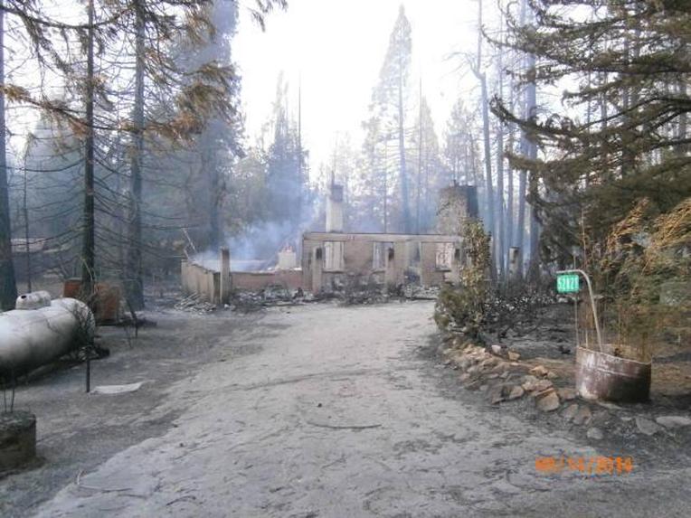
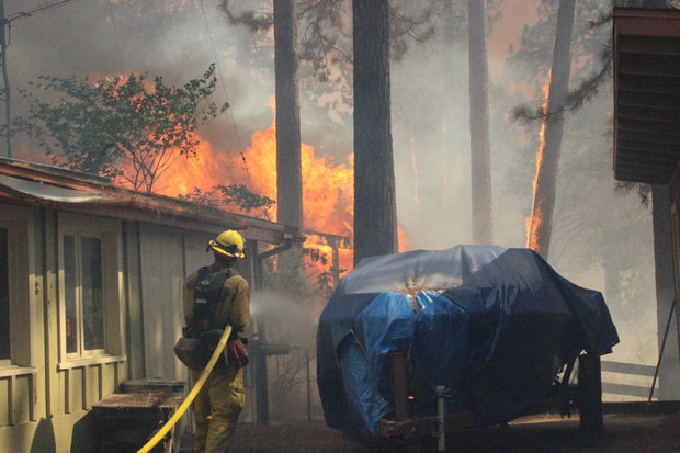
OAKHURST — A fire that swept from outside of Oakhurst to the edge of Bass Lake on Sunday damaged or destroyed 21 structures, blackened 320 acres and prompted an evacuation of hundreds of residents and visitors, including from the Bass Lake resort area.
A neighborhood around Cedar Drive and Road 426 was hit especially hard, with several homes turned to ash and smoldering embers.
Cal Fire Battalion Chief Chris Christopherson said he believed more than 10 homes had been lost, the majority off of Road 426 near Manzanita Drive on the crest of the hill.
"This is gut-wrenching," Christopherson said. "It makes you sick."
Jon Cunningham was among the unlucky.
Cunningham, 72, was home when he smelled the fire and saw the orange sky.
Cunningham told his wife there was a fire coming. Then he turned and saw the black smoke coming from the other side of the mountain.
"My wife and I looked back and saw our backyard was burning," he said. "So we didn't take much time. She drove one car, I drove the other car and we just left."
The couple grabbed what they could: one suitcase each, a computer and some business records.
Photo albums, handmade furniture, a 1930s piano, tools and everything else stayed behind and burned.
Cunningham's three-bedroom, two-bath house on Pine Drive is now ashes.
"When we got to the corner of (Road) 426, two large fir trees were just flaming like candles," he said.
He and his wife are staying with friends in Pierce Lakes. It's the first time they've lost a house in a fire, and they don't know what comes next.
"Pretty soon it'll settle in," he said, "but right now you deal with it as it comes."
The fire, stoked by winds, threatened 400 homes and prompted officials to order the evacuation of about 1,000 people as well as their animals.
The American Red Cross opened evacuation centers at Oakhurst Community Center and North Fork Town Hall. Pets were being accepted at the Oakhurst shelter. North Fork was expected to have a pet shelter in place by Sunday night.
Large animals that are evacuated and need shelter can go to the Coarsegold Rodeo Grounds off Road 415, south of Coarsegold School, Cal Fire said. Those evacuating are asked to first call Thomas Bohna at (559) 760-5577.
At the Oakhurst Community Center, more than 30 residents had checked in as of 6 p.m., said community volunteer Jerry Ongman.
One of those evacuees, Mary Goddard, 75, an Oakhurst resident since 1997, said this is the fourth Oakhurst fire she's seen from her home this summer. "We've had too many ... I want to go home."
This is the first time she and her husband, Peter Goddard, 80, have been evacuated. "I'm scared, shaky, not sure if everything is OK."
Dozens of residents had parked along Highway 41 on Deadwood mountain on Sunday afternoon, pointing at smoke plumes and aircraft buzzing above the flames.
The Bass Lake area was under pre-evacuation advisory notice Sunday night. As of 7 p.m., that has been reduced to advisory status for everything north of Recreation Point, including Road 432, Slide Creek and World Mark.
Cal Fire Capt. Frank Bigelow Jr. said the fire was moving slowly and fire officials didn't anticipate more evacuations Sunday night, although residents should "stay vigilant and stay aware of what's going on."
The cause is under investigation, Bigelow said. Fire crews had containment lines around 20% of the fire as of Sunday night, and said steep terrain and brush left dry by the drought have contributed to extreme fire behavior.
The fire started around 1:35 p.m. off Courtney Lane and headed uphill, cresting the ridge and then turning to the north and to the edge of Bass Lake.
Tom Tuso, manager of Bass Lake Water Sports and Boat Rentals, said Sunday around 5 p.m. that he had just been told by the sheriff's office to evacuate the business. At the time, five rental boats with about 50 people were out on the water.
"We're calling our guests and telling them to bring their boats back and following orders," he said by phone. "We should be out of here within the next 15-30 minutes."
Tuso said he could see 50-foot flames right across the lake. He said fire officials asked that the area near Angel Falls be cleared out so helicopters could land.
"They chased the fire down to the lake," he said. "Now the wind shifted and it appears it is turning around and going back up toward Oakhurst."
April Rodriguez, a front desk agent at The Pines Resort reached by phone around 5:30 p.m. Sunday, said the scene wasn't too hectic because everyone knew in advance what the game plan was if the pre-evacuation notice changed. Around 5 p.m., the resort was asked to evacuate, she said.
Rodriguez said 31 rooms would be evacuated and those due to check in Sunday night were being rerouted to safer areas.
"This (fire) actually was the closest one for us," she said. "The Junction fire luckily did not go over the ridge. This one is a little bit more interesting."
The Junction fire, which started in Oakhurst on Aug. 18, destroyed 47 structures, including the Suburban Propane office and at least eight homes, and damaged six structures.
"This is very similar to how the Junction fire moved through Oakhurst last month," the sheriff's office said on its Facebook page.
About 400 firefighters and other personnel swarmed into the Oakhurst and Bass Lake areas and continued working through the night. Fifteen aircraft also aided firefighting efforts Sunday.
Road closures in effect included Road 426 near Suncrest to Road 223; Road 222 to Road 432; Road 222 at Road 426; and Road 223 at Road 420 (Thornberry Road).
School closures
The Courtney fire prompted school officials to close the following schools on Monday: Yosemite High School, Ahwahnee High School, Campbell High Community Day, and Evergreen High School in Oakhurst.
In the Bass Lake Joint Union Elementary School District, closures include Wasuma Elementary, Oakhurst Elementary and Oak Creek Intermediate schools.
Yosemite Unified School District's "Back to School Night" originally scheduled for Monday has been postponed.
The reporters can be reached at [email protected], [email protected] or (559) 441-6330.
Read more here: http://www.fresnobee.com/2014/09/14/4123537/wildfire-near-oakhurst-prompts.html#storylink=cpy
Your browser does not support viewing this document. Click here to download the document.
Your browser does not support viewing this document. Click here to download the document.
Your browser does not support viewing this document. Click here to download the document.
Your browser does not support viewing this document. Click here to download the document.
