WawonaNews.com - October 2020

WAWONA LARGE ITEM PICK UP
The Mariposa County Public Works will again pick up large items in Wawona on Saturday, October 10, 2020. The truck will arrive in the Wawona maintenance yard at 9 a.m. that morning and depart at 3 p.m. Large household furnishings, appliances, deck furniture, etc. will be accepted. No hazardous waste or electronics will be accepted. Thanks to Miles Menetrey for facilitating this for Wawona property owners!
The Mariposa County Public Works will again pick up large items in Wawona on Saturday, October 10, 2020. The truck will arrive in the Wawona maintenance yard at 9 a.m. that morning and depart at 3 p.m. Large household furnishings, appliances, deck furniture, etc. will be accepted. No hazardous waste or electronics will be accepted. Thanks to Miles Menetrey for facilitating this for Wawona property owners!
Creek Fire Update:
Size: 316,673 Acres, Contained: 49%
Creek Fire Update:
Size: 311,703 Acres, Contained: 45%
Dancing At Camp Curry in 1958 - by Tom Bopp
Enhanced Stage 2 Fire Restrictions
Yosemite National Park is experiencing poor air quality due to the Creek Fire, which is an ongoing wildfire burning near Yosemite National Park. The smoke from this fire is degrading air quality throughout the park by creating unhealthy levels of particulate matter. In response, Yosemite National Park has implemented park-wide Stage Two Fire Restrictions with an additional enhancement to reduce the negative impacts and unhealthy effects of wildfire smoke.
By order of the Superintendent of Yosemite National Park and under authority of Title 36, Code of Federal Regulations, Sections 1.5(a) 1.5(a)(1), 2.13(a)(1) and 2.13(c).
Permissible actions include:
There are no administrative exemptions to this order. Notice of closure will be posted and areas will be monitored to ensure compliance. This designation will remain in place until rescinded.
-NPS-
For information on fire restrictions in Yosemite National Park, visit:
https://www.nps.gov/yose/planyourvisit/firerestrictions.htm
For information on planning your visit in Yosemite National Park visit:
ww.nps.gov/yose
Yosemite National Park is experiencing poor air quality due to the Creek Fire, which is an ongoing wildfire burning near Yosemite National Park. The smoke from this fire is degrading air quality throughout the park by creating unhealthy levels of particulate matter. In response, Yosemite National Park has implemented park-wide Stage Two Fire Restrictions with an additional enhancement to reduce the negative impacts and unhealthy effects of wildfire smoke.
By order of the Superintendent of Yosemite National Park and under authority of Title 36, Code of Federal Regulations, Sections 1.5(a) 1.5(a)(1), 2.13(a)(1) and 2.13(c).
- Enhancement: Wood fires are prohibited park-wide. Burning wood in campgrounds, picnic areas, outdoor residential areas, and Wilderness is not permitted.
- The building, maintaining, or attending of a charcoal fire, or twig stove is prohibited park-wide at all elevations, including Wilderness.
- Smoking is prohibited except within an enclosed vehicle, a building in which smoking is allowed, designated campgrounds, designated picnic areas, paved developed areas, and designated smoking areas.
- Fireworks are always prohibited.
Permissible actions include:
- Portable stoves using pressurized gas, liquid fuel, or propane are permitted, as are alcohol stoves (with and without a shutoff valve) including alcohol tablet/cube stoves.
- Charcoal fires may be used in designated open campgrounds and open picnic areas with park-installed grills in developed portions of the park, in accordance with park regulations.
- Charcoal fires and indoor wood fires may be used in residential areas in developed portions of the park in accordance with park regulations.
There are no administrative exemptions to this order. Notice of closure will be posted and areas will be monitored to ensure compliance. This designation will remain in place until rescinded.
-NPS-
For information on fire restrictions in Yosemite National Park, visit:
https://www.nps.gov/yose/planyourvisit/firerestrictions.htm
For information on planning your visit in Yosemite National Park visit:
ww.nps.gov/yose
Day Use Reservation System to End on November 1
Yosemite National Park is announcing modifications to operations to implement the latest guidance from the White House, Centers for Disease Control & Prevention (CDC), and local and state public health authorities, as the park continues to increase public access and services. The NPS is working servicewide with federal, state, and local public health authorities to closely monitor the COVID-19 pandemic and using a phased approach to increase access on a park-by-park basis.
Yosemite National Park will be modifying park operations beginning on November 1, 2020, ending the day use reservation system that has been in place since the park reopened in June.
Day use reservations will be in place through the month of October. To secure a day use reservation, please visit www.recreation.gov. Day use passes will not be required for entrance into Yosemite National Park beginning on November 1, 2020.
“We would like to extend our gratitude to all park visitors and our local communities for their support of our modified operations this summer,” stated Acting Superintendent Cicely Muldoon. “With the health and safety of park visitors and employees guiding our decisions, we were thrilled to welcome thousands of visitors to Yosemite this summer.”
Since March 2020, Yosemite National Park has been part of the Yosemite Gateway Area Coordination Team (YOGACT), a group consisting of public health, public safety, and elected officials from Madera, Tuolumne, Mariposa, and Mono Counties. Other agencies in the group include the U.S. Public Health Service, U.S. Forest Service, Bureau of Land Management, and the National Park Service. This group has been collaborating, and continues to collaborate, on public health and safety issues affecting Yosemite National Park and the greater Yosemite region. This group’s collective efforts have resulted in the park being able to reopen in June and stay open throughout the busy summer season. Based on changing conditions and public health guidance, this group works in alignment on decisions affecting visitors and residents of the Yosemite region.
Yosemite National Park continues to urge visitors to do their part when visiting and to follow CDC guidance to prevent the spread of infectious diseases by maintaining a safe distance between yourself and other groups; wear a cloth face covering when social distancing cannot be maintained; washing your hands often with soap and water for at least 20 seconds; avoiding touching your eyes, nose, and mouth; covering your mouth and nose when you cough or sneeze; and most importantly, staying home if you feel sick.
For current road and weather conditions in Yosemite National Park, please call 209-372-0200, and press 1. Updated information is also available on the park’s website at www.nps.gov/yose and on the Yosemite National Park Facebook page.
The Rangers' Club
A Tree - by Tom Bopp
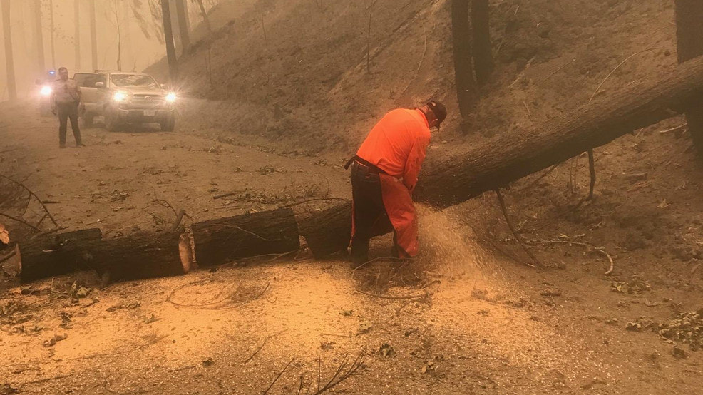
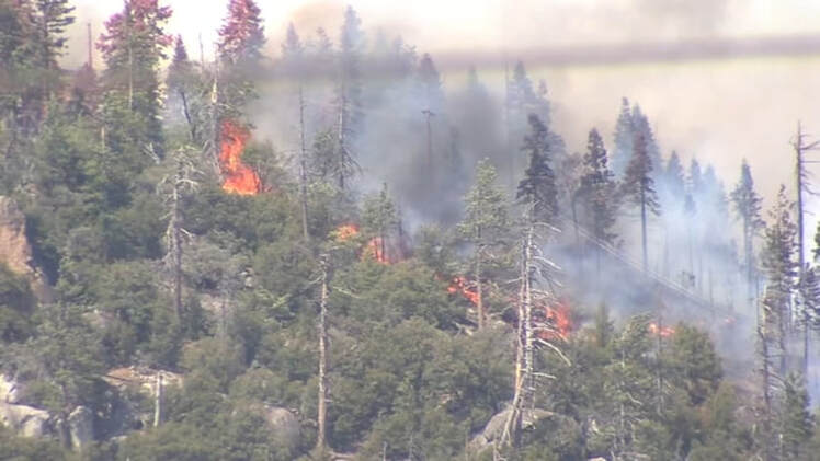
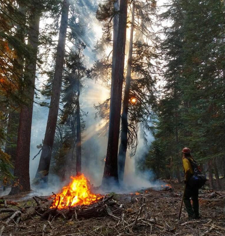 Yosemite Wildland Firefighter monitors fire near Tioga Road, 9.21.2020. NPS Photo.
Fire Update September 25 - October 1, 2020
There are multiple fires burning in Yosemite National Park. Each fire is burning in Wilderness, in a fire adapted ecosystem. There are multiple trail closures in effect around Yosemite Creek and the southern part of the park. All fires may be visible from Tioga Road (Highway 120 through Yosemite National Park), Glacier Point, and high country vistas. Smoke from each fire is settling locally at night and in the morning then rising and dispersing to the north and northeast in the early afternoon. Park managers are working with the local Air Quality Districts to monitor smoke impacts to the park and local communities. Smoke from ongoing Southern and Central Sierra fires continue to impact the area.
Blue Jay Fire
Location: 4 miles south of White Wolf Campground and 1 mile west of Lukens Lake Trail at approximately 9,000 feet elevation.
Discovery Date: July 24, 2020
Size: 4,498 acres
Containment: 50%
Strategy: Confine and Contain
Cause: Lightning
Activity has diminished substantially due to cooler weather conditions and smoke inversion in the area. Primary direction of growth is to the north and northwest from Tioga Road at McSwain Summit. Unmanned Aircraft Systems (UAS) support for aerial reconnaissance and mapping, Infrared Detection (IR), and aerial ignition concluded this week. UAS support benefited firefighting operations immensely where firefighters could not access terrain on foot.
inciweb.nwcg.gov/incident/6888/
Wolf Fire
Location: 1 mile north of White Wolf Campground and 2 miles east of Lukens Lake Trail at approximately 9,000 feet elevation.
Discovery Date: August 11, 2020
Size: 1,087 acres
Containment: 35%
Strategy: Confine and Contain
Cause: Lightning
The fire has a 50% active perimeter, primarily on the southeastern edge. The fire is burning in dense pockets of vegetation and accumulated dead and down logs and is creeping along the forest floor, with some isolated single tree torching and short range spotting along the active perimeter.
inciweb.nwcg.gov/incident/7134/
North Whizz Dome Fire
Location: 4/10 mile south of Cathedral Creek and 1 mile northwest of Tioga Road at approximately 8,400 feet elevation.
Discovery Date: August 27, 2020
Size: 75 acres
Containment: 0%
Strategy: Monitor
Cause: Lightning
The fire has a 15% active perimeter, primarily on the western edge. The fire is burning in heavy fuels, ground litter, and pockets of accumulated dead and down logs with isolated single tree torching. Fire personnel will continue to monitor fire behavior and growth.
inciweb.nwcg.gov/incident/7135/
Horse Fire
Location: Horse Ridge, 1 mile southeast of Ostrander Lake at approximately 9,500 feet elevation.
Discovery Date: August 24, 2020
Size: 35 acres
Containment: 0%
Strategy: Monitor
Cause: Lightning
The fire is creeping and smoldering through sparse vegetation in a very rocky area. There are currently no threats to trails or infrastructure. Fire personnel will continue to monitor fire behavior and growth.
https://inciweb.nwcg.gov/incident/7149/
These updates will happen weekly unless significant activity occurs. For the most up-to-date fire information go to: Inciweb
Yosemite Fires Web Map
Fire Update Printable PDF
Yosemite Fires Map Printable PDF
-NPS-
- Air Quality: Yosemite Air Quality Page or airnow.gov or airnow.gov/fires
- Sign-up for Alerts: go.nps.gov/alert
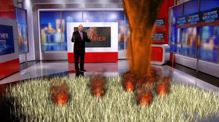
California's Largest Single Wildfire Spawned Two Massive Firenados -- One Was an EF2
(
CNN)California's Creek Fire is not only the largest single wildfire in the state known for huge and destructive blazes, it spawned two rare firenados a day after the fire started earlier this month.
One firenado -- short for fire tornado -- was rated an EF-2, with winds up to 125 miles per hour. The other had winds of up to 100 miles per hour and was rated an EF-1.
They wreaked havoc across the rugged area, the result of "unprecedented fire behavior," government forecasters said Thursday.
Fire tornadoes are created when the rising heat from a fire pulls in smoke, fire and dirt, creating a rotation vortex above the blaze, according to CNN meteorologist Haley Brink.
"To have even one tornado within a fire is rare," CNN meteorologist Taylor Ward said. "Fires can lead to fire whirls -- kind of like a dust devil -- due to differential heating, but to get a tornado with winds of over 100 mph is quite unusual."
The tornadoes uprooted pine trees, snapping even several 2-foot diameter trees and stripping bark from their trunks, a storm survey report said.
The historic wildfires California is experiencing this year have generated intense heat, causing the vortices to form, meteorologist Jerald Meadows at the National Weather Service office in Hanford, California, told CNN on Thursday.
While Meadows can't say for certain the state is seeing more firenados than in the past, he said we will learn more as the technology has improved to track and monitor their formation.
It's not the first time this year the phenomenon has occurred: The Loyalton Fire in Northern Calfornia, near Nevada, spawned one last month. The Creek Fire, which started on September 4, has burned 291,426 acres in the Sierra National Forest and remains just 34% contained.
Both Creek Fire firenados occurred September 5, the first near Huntington Lake, and the second near Mammoth Pool, where a rescue operation airlifted hundreds of trapped people to safety. CNN's Theresa Waldrop contributed to this report.
Yosemite Reopens Friday, September 25
Yosemite National Park will reopen to all park visitors on Friday, September 25, 2020 at 9:00 am. Some visitor services will be available and other visitor services will open incrementally over the weekend.
The park has been closed since September 17 due to smoke impacts and hazardous air quality throughout the park.
Yosemite National Park officials continue to monitor air quality conditions throughout the park. The park continues to confer with local and federal public health experts on air quality, smoke impacts, and resulting impacts on public health. Yosemite National Park, or portions of the park, may close intermittently due to changes in air quality and smoke impacts. For information on current air quality and smoke impacts, please visit https://fire.airnow.gov/?lat=37.672508866650354&lng=-119.80573.
For updated 24-hour road and weather conditions for Yosemite National Park, please call 209-372-0200, and press 1. For any questions about vacation home rentals please call us at (877) 221-4904.
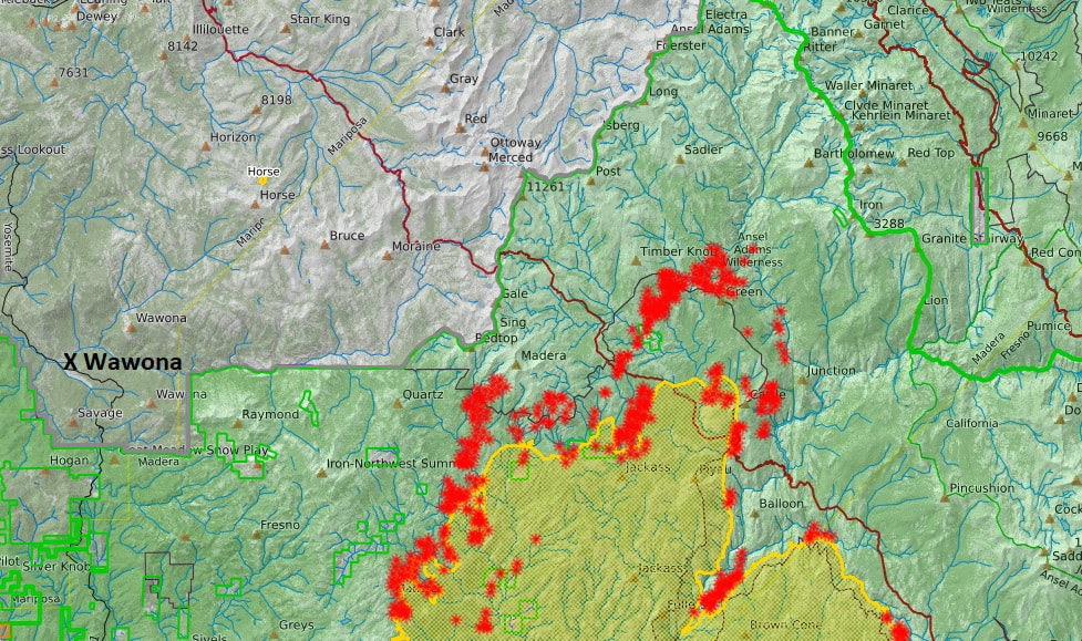
Creek Fire No Longer a Threat to Wawona - Advisory Lifted
The fire advisory for the Wawona area has been lifted. The Creek Fire continues to burn in the area, although there is no longer a threat to the Wawona area. View updates on InciWeb: https://go.usa.gov/xGm5t.
The fire advisory for the Wawona area has been lifted. The Creek Fire continues to burn in the area, although there is no longer a threat to the Wawona area. View updates on InciWeb: https://go.usa.gov/xGm5t.
Creek Fire Report, September 21st, 4:30 PM
Size: 280,425 Acres, Contained: 30%
InciWeb
Madera County: The current hot, dry weather pattern will continue; however, winds will be mild. This will moderate fire behavior and provide firefighters an opportunity to implement their plans. Fire containment lines in Madera County now extend from the San Joaquin River to Peckinpah Meadows. Today fire crews will continue back-burning operations along FR 8S09 between Peckinpah Meadows and the Whisky Falls area. The back-burns help remove fuels and fortify the dozer lines that have been put in place to help stop advancement of the fire. Early this morning a small area of fire was pushed by down-sloping winds towards Central Camp and approached one of these dozer lines. A crew of firefighters had already been staged in this area late last night, and was used to protect this line. The fire perimeter north of Central Camp to Little Shut Eye Peak has had minimal growth. The protection of the communities along the fire’s western edge continues to be the highest priority. The fire has burned into higher elevations along the north and northeastern boundaries and is slowing as it moves into areas with sparse timber and high rock concentrations. This area of fire is also approaching the Lions Fire burn scar. This 13,000-acre scar lacks adequate fuels to sustain forward progress. These natural features will begin to impede fire progress and give Air Operations a chance to contain this area of fire once the smoke clears enough to fly safely.
Weather ConcernsNorth Zone: Smoke continues over the fire area and will continue for the next 72 hours. The ridges and upper slopes were drier today and will continue to be quite dry the next 72 hours with higher humidity on the lower slopes. RH will drop into the teens for ridges and into the 20s for lower elevations while overnight recovery is moderate, near 50% and 30-35% for the thermal belts. Overall, winds will be terrain driven, with southwest winds on the ridges during the day gusting to 20-25 mph with light downcanyon winds at night.
Rules Proposed by State Insurance Commissioner Offer Discount for Reducing Wildfire Risks
JOSEPH SERNA LA Times STAFF WRITER
After multiple years of insurers dropping homeowners’ policies in areas hard-hit by wildfires, the state insurance commissioner is pushing for regulations that would offset rising premiums with discounts for mitigating wildfire risks.
On Oct. 19, the Department of Insurance will host an investigatory hearing where homeowners, industry experts and insurance providers, among others, can give their input into regulations Commissioner Ricardo Lara plans to initiate that would probably accelerate premium increases for some homeowners while giving them a chance to learn how their property’s risk is calculated and opportunities to reduce it, Lara’s office said.
“The reality is climate change is going to continue to disrupt communities through extreme heat and weather and affect our insurance markets,” Lara said. “Using my authority as a regulator to look at these key areas is really going to be critical.”
For several years now, the housing market in California’s expanding wildland-urban interface, the area where suburbia blends with the wildlands, has been rocked by wind-driven fires that have wiped out housing stock and years of insurers’ profits along with it. In response, insurers have been dropping policies in those at-risk areas by the thousands, pushing people into the secondary market, and dramatically raising the premiums for many others, arguing that the tandem moves are meant to limit their financial risks.
But at the same time, consumer advocates say, insurers have been slow-rolling the rate increases across the rest of their portfolio, keeping the increases overall below 7% annually so it doesn’t open them up for a public inspection, enabled under Proposition 103, approved in 1988.
Lara’s office said it would push for insurers to seek rate increases more reflective of the risks the companies’ actuaries spell out, which means probably higher than 7%, but it would also require insurers provide more information to homeowners on what they can do to reduce those risks.
“Time and time again we heard from consumers, ‘How do I appeal my score? How do I know what I need to do to lower that score?’ And right now there’s nothing,” Lara said.
To soften the rate-increase impact, Lara said his office will require that insurers provide and explain the reasoning behind a homeowner’s particular fire risk score. Thousands of homeowners in the last few years have received notices when their policies ended telling them they were suddenly uninsurable because of fire risks, or conversely, that it would cost prohibitively more to remain covered and there was nothing they could do to change it.
“We’re saying, ‘Let’s promote transparency and recognize that home-hardening, that’s science-based, works,” Lara said.
To that end, insurers have been working with the Insurance Institute for Business & Home Safety to outline a standard approach to home hardening on an individual and communitywide scale, which wildfire experts say is key to limiting the loss of life and property. Lara said he’ll work with those groups to determine what types of strategies homeowners can take to reduce their risks and get a discount. A failed Assembly bill that Lara endorsed earlier this year would have required insurers to cover homes whose owners reduced their risks.
Historically, Californians have a spotty track record of mitigating their wildfire risks on a large scale, and with few exceptions, local governments have done a poor job of enforcing the standards that already exist. Both consumers and local governments will have a role in seeing the proposed regulations bear fruit after statewide mitigation standards are set.
“We’re incentivizing the consumer and incentivizing the local community to bring down the risk and keeping the insurance market vibrant where they’re competing for people’s businesses,” Lara said.
One insurance group, the American Property Casualty Insurance Assn., which represents about 60% of the property casualty insurance market, welcomed the upcoming hearing as an opportunity to revisit the rate-making process overall. Insurers have complained that California’s laws don’t allow them to price in the increasing risks linked to climate change because they can set rates based only on past losses.
“APCIA applauds the commissioner’s interest in improving the regulatory system to encourage more insurers to write insurance in high-risk wildfire areas and give consumer more choices,” the group said in a statement. “Clearly, California is facing dramatically different conditions with five of the state’s largest fires occurring just this year. Climate change is altering conditions in California and we expect this to be the ‘new normal.’”
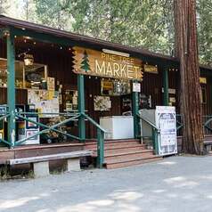
New "Smoke Closure" Hours for Pine Tree Market
|
|
Creek Fire Evening Briefing Video - September 20
Size: 278,368 Acres, Contained: 27% , "Things going very well"
Yosemite National Park Remains Closed Due to Hazardous Air Quality
Park through roads now accessible for drive through traffic
Yosemite National Park remains closed due to hazardous air quality. However, park through roads are now accessible for vehicular traffic desiring to drive through the park. Limited services are available throughout the park. Visitors should be prepared to drive through without stopping.
Accessible roads for driving through Yosemite National Park include the Wawona Road (continuation of Highway 41), the El Portal Road (continuation of Highway 140), and the Big Oak Flat and Tioga Roads (Continuation of Highway 120). Limited restroom facilities are available on all road corridors.
The Glacier Point Road and the Mariposa Grove Road will remain closed. All lodging facilities, restaurants, campgrounds, and visitor centers remain closed.
Yosemite National Park officials continue to confer with local and federal public health experts on air quality and human health and safety. The park will reopen when conditions improve and allow for the health and safety of park visitors and employees to engage in regular park activities.
Visitors utilizing park roads are required to stay in their vehicles as they drive through Yosemite National Park. Prohibited activities in Yosemite National Park include hiking, cycling, camping, climbing, etc.
For detailed information on current air quality and smoke impacts, please visit https://fire.airnow.gov/?lat=37.672508866650354&lng=-119.80573
For updated 24-hour road and weather conditions for Yosemite National Park, please call 209-372-0200, and press 1. Updated information is also available on the park’s website at www.nps.gov/yose and on the Yosemite National Park Facebook page.
-NPS-
Creek Fire Size: 271,938 Acres, Contained: 25%
InciWeb SPet. 19, 7:00 PM
North Zone:
Moderate fire activity this morning on multiple portions of the fire, with group torching as the drying of the fuels continues. The fire remained active on the North and North West sections of the fire through the afternoon. Fire activity will be low overnight. Whisky Falls and Browns Meadow will have the most active fire. Smoke will continue to be a concern the next several days, but will be less than previous days. Smoke remained in the canyons with haze on the upper slopes and ridges. The next 72 hours will see terrain-driven winds each day, with ridge winds from the southwest. Ridge winds may be a bit stronger Monday afternoon with gusts to 25 mph. Temperatures will warm with relative humidity lower the next 72 hours, but still be near seasonal values. Overnight relative humidity recovery will be fair.
|
|
 Wawona Store and Post Office 10 AM to 4 PM Wawona Store and Post Office 10 AM to 4 PM
New Post Office and Stores Hours During Park Closure
|
Creek Fire North Zone Morning Briefing - September 19
Creek Fire Perimeter Map - September 19
Click on image for live view
Creek Fire Briefing Video, September 18
Size: 248,296 Acres, Contained: 22%, "Great Day", 0.25 Inches In Northern Area, Very Little Fire Growth
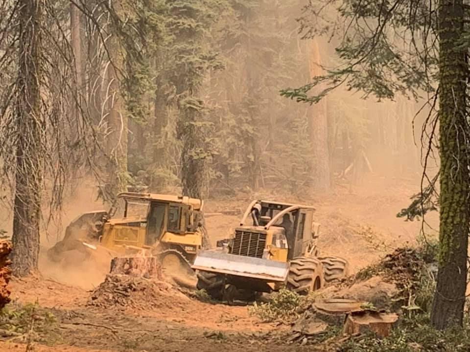
Plucked Like Feathers
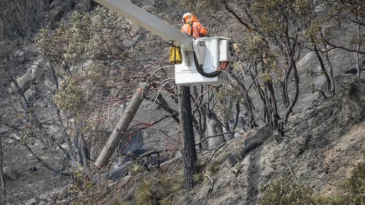
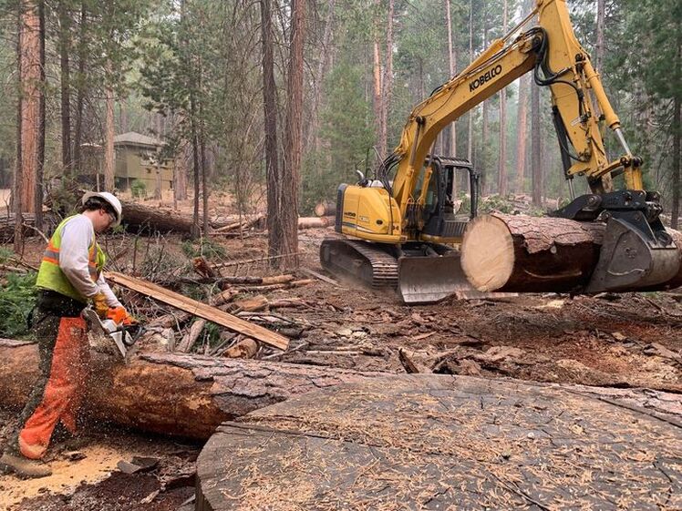
#CreekFire is utilizing additional heavy equipment on the fire's west perimeter. This Feller Buncher speeds up indirect line construction by removing fuels (trees and vegetation). The fuels are removed from the fires edge to help reduce fire intensity and chances of spotting. Dozers and fire fighters will follow behind the buncher to additionally clear fuels.
Creek Fire Morning Briefing - September 18
1980s Hotel Projects - by Tom Bopp
 Yosemite staff getting set for additional wildfire activity throughout the park.
Creek Fire Morning Update 9/18/20 9:30 AM
248,296 Acres, 20% Containment
Madera County: Weather conditions for today will feature increasing humidity along with the chance for light showers in the region. This humidity will help reduce the volatility of spot fires, and slow progression of the fire in the north and northeastern sections of the fire. This weekend, down-sloping winds and an inversion layer will return once again trapping smoke in lower elevations and valleys.
Yosemite, Sequoia, and Kings Canyon National Parks have all been closed to the public. The Parks were closed due to the unhealthy smoke conditions, and not because of the threat of fire spread. Any remaining visitors in these National Parks will be evacuated today. All visitors and recreationists reported to be in the Forests have been accounted for and have exited the park with no injuries reported.
Work continues on the west flank to fortify contingency lines and to protect assets such as Central Camp and the Bass Lake area. The tactics deployed in this area will provide options for our firefighting operations depending on how the fire reacts to the changing weather conditions in this area.
Preparations continue for the community of Mammoth Lakes as winds push the Creek Fire to the northeast. Management Action Points (MAPs) have been established as virtual lines on the map in relation to fire location. If the fire crosses any of these MAPs, Emergency Officials will enact appropriate actions to protect life and property. All concerned in this specific region can visit the Sierra National Forest Facebook page, or use the following link for information: https://creek-fire-preparedness-monomammoth.hub.arcgis.com
As weather conditions allow air operations to resume, please respect the Temporary Flight Restriction; keep drones away from the fire and firefighting operations. If you fly, we can’t! Don’t be the reason a firefighting air mission has to divert!
.
Fresno County: On Friday, the Creek Fire’s South Zone should experience less fire activity this morning than during the previous operations periods. An overnight weather system brough high level tropical moisture to the fire, increasing cloud cover and humidity and very light showers were experienced in the fire area. This pattern will linger into Friday morning, and gusty southwest winds return in the morning along with seasonal temperatures, humidity, and local upslope and upcanyon winds.
While precipitation may occur, it is forecast at less than 1/10th of an inch. It will reduce fire activity in finer fuels such as grasses and brush but will not affect heavier fuels like timber. For this reason, as the weather system moves out Friday afternoon southwest winds will increase. This presents the likelihood that fire in the afternoon into the overnight periods will be more substantial than the daytime.
Last night the fire behavior was centered around Huntington Lake around China Peak. It will also progress towards Florence Lake and the Dinkey Lakes Wilderness. It should be noted substantial heat remains in the heavier fuel loads, in which smoldering will be observed until complete mop-up can occur.
Operationally for the next twenty-four and forty-eight hours, the priority remains increasing containment through perimeter control and direct attack of any open flames and mopping up inside the current fire area. This will be accomplished through utilizing bulldozers and building new line and improving existing lines. Where the terrain limits accessibility of bulldozers, hand-crews are assigned to complete this task in Blue Canyon and Sycamore Creek and some portions of the southwest area of the fire.
#FireYear2020
Great Basin National Incident Management Team #1
CAL FIRE
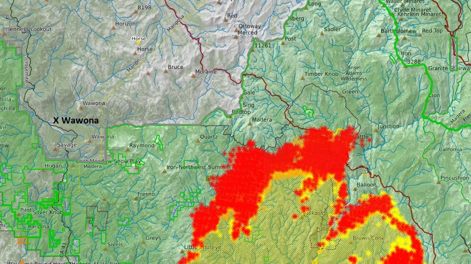
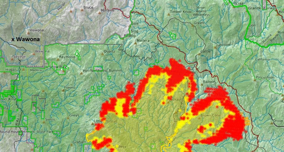
The Smaller Fires In Yosemite
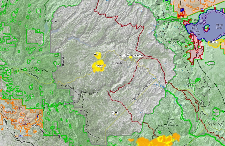
Click on map for live view
Fire Update September 18-24, 2020
There are multiple fires burning in Yosemite National Park. Each fire is burning in Wilderness, in a fire adapted ecosystem. There are multiple trail closures in effect around Yosemite Creek and the southern part of the park. All fires may be visible from Tioga Road (Highway 120 through Yosemite National Park), Glacier Point, and high country vistas. Smoke from each fire is settling locally at night and in the morning, then rising and dispersing to the north and northeast in the early afternoon. Park managers are working with the local Air Quality Districts to monitor smoke impacts to the park and local communities. Heavy smoke from the Creek Fire continues to impact the area.
Blue Jay Fire
Location: 4 miles south of White Wolf Campground and 1 mile west of Lukens Lake Trail at approximately 9,000 feet elevation.
Discovery Date: July 24, 2020
Size: 4,061 acres
Containment: 40%
Strategy: Confine and Contain
Cause: Lightning
Activity has diminished substantially due to cooler weather conditions and smoke inversion in the area. Primary direction of growth is to the north and northwest from Tioga Road at McSwain Summit. Spotting north of Tioga Road is smoldering and creeping, with occasional small group torching. Fire crews are utilizing Unmanned Aircraft Systems (UAS) for aerial reconnaissance and mapping, Infrared Detection (IR), and aerial ignition. This type of aerial ignition aids fire personnel by gaining depth along natural containment lines in areas that firefighters cannot access on foot.
inciweb.nwcg.gov/incident/6888/
Wolf Fire
Location: 1 mile north of White Wolf Campground and 2 miles east of Lukens Lake Trail at approximately 9,000 feet elevation.
Discovery Date: August 11, 2020
Size: 900 acres
Containment: 25%
Strategy: Confine and Contain
Cause: Lightning
The fire has a 30% active perimeter, primarily on the southeastern edge. The fire is burning in dense pockets of vegetation and accumulated dead and down logs and is creeping along the forest floor, with some isolated single tree torching and short range spotting along the active perimeter.
inciweb.nwcg.gov/incident/7134/
North Whizz Dome Fire
Location: 4/10 mile south of Cathedral Creek and 1 mile northwest of Tioga Road at approximately 8,400 feet elevation.
Discovery Date: August 27, 2020
Size: 85 acres
Containment: 0%
Strategy: Monitor
Cause: Lightning
The fire has a 50% active perimeter burning in heavy fuels through ground litter on the forest floor and burning in pockets of accumulated dead and down logs with some isolated single tree torching. Fire personnel will continue to monitor fire behavior and growth.
inciweb.nwcg.gov/incident/7135/
Horse Fire
Location: Horse Ridge, 1 mile southeast of Ostrander Lake at approximately 9,500 feet elevation.
Discovery Date: August 24, 2020
Size: 23 acres
Containment: 0%
Strategy: Monitor
Cause: Lightning
The fire is creeping and smoldering through sparse vegetation in a very rocky area. There are currently no threats to trails or infrastructure. Fire personnel will continue to monitor fire behavior and growth.
https://inciweb.nwcg.gov/incident/7149/
These updates will happen weekly unless significant activity occurs. For the most up-to-date fire information go to : Inciweb
Yosemite Fires Web Map
Fire Update Printable PDF
Yosemite Fires Map Printable PDF
-NPS-
- Air Quality: Yosemite Air Quality Page or airnow.gov or airnow.gov/fires
- Sign-up for Alerts: go.nps.gov/alert
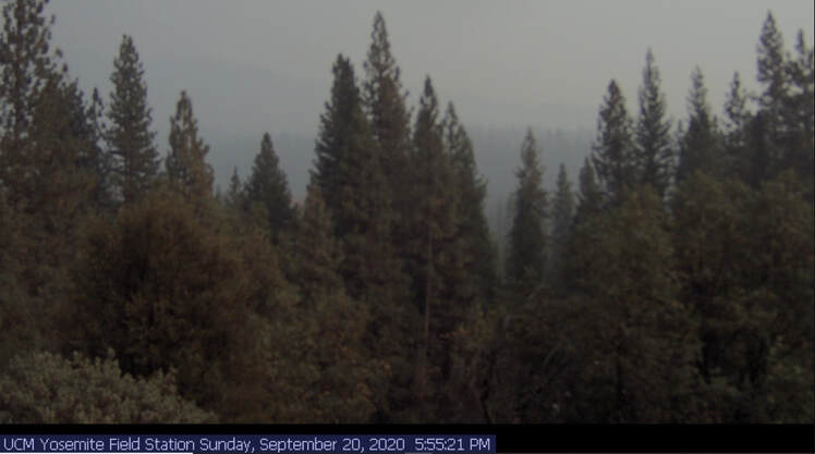
Wawona Smoke Conditions 8:00 AM, September 18
null
null
Creek Fire Permiter Map 7:30 AM, September 18 As Rain Falls In The Area
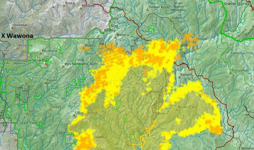
Click on map for updated live view
Creek Fire Perimeter With Fire History Near Wawona
20% Contained - Sept. 17, 8 PM
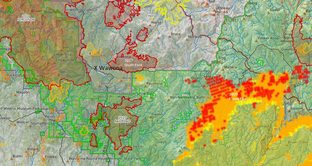
Current Creek Fire Perimeter on bottom, right, with previous fires around Wawona. Click on the map for a live view of the Creek Fire's perimeter.
Yosemite Closes Due to Smoke Conditions
This is a message from Yosemite National Park.
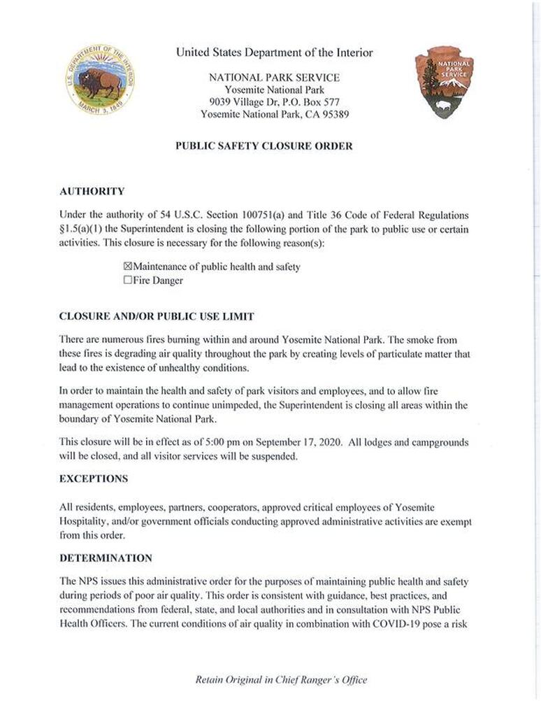
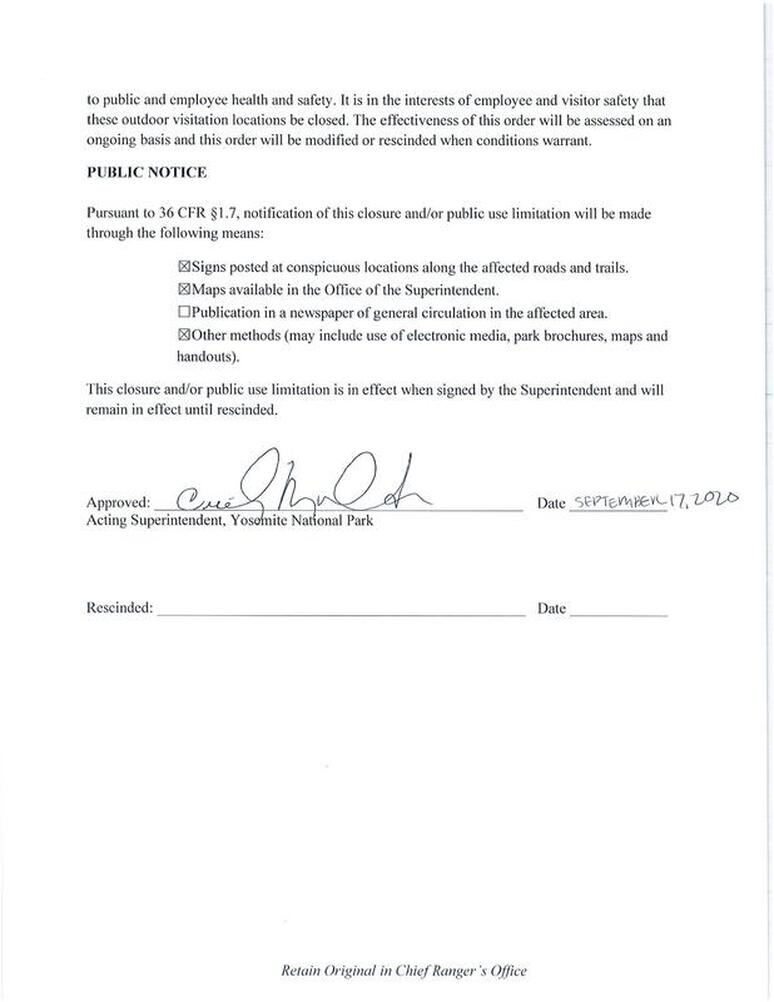
Yosemite National Park announces that the park will close to all visitors and vehicular access due to significant smoke impacts and hazardous air quality throughout the park. All park entrance stations and roads will close beginning at 5:00 pm tonight, Thursday, September 17, 2020. Employees, property owners, residents will still be allowed to come and go.
With air quality projected to be in the unhealthy to hazardous range over the next several days, the park anticipates the closure to be in effect at least throughout the weekend. The park will continue to assess the smoke impacts, air quality index, and fire activity throughout the region. Yosemite National Park will reopen to visitors when conditions improve, and it is safe for visitors and employees to be in Yosemite National Park.
Yosemite National Park's closure is in alignment with the closure of Sequoia and Kings Canyon National Parks and the surrounding national forests.
For detailed information on current air quality and smoke impacts, please visit https://fire.airnow.gov/ ?lat=37.672508866650354&lng=- 119.80573
For updated 24-hour road and weather conditions for Yosemite National Park, please call 209-372-0200, press 1 and press 1 again. Updated information is also available on the park’s website at www.nps.gov/yose and on the Yosemite National Park Facebook page.
This is a message from Yosemite National Park.
Yosemite National Park announces that the park will close to all visitors and vehicular access due to significant smoke impacts and hazardous air quality throughout the park. All park entrance stations and roads will close beginning at 5:00 pm tonight, Thursday, September 17, 2020. Employees, property owners, residents will still be allowed to come and go.
With air quality projected to be in the unhealthy to hazardous range over the next several days, the park anticipates the closure to be in effect at least throughout the weekend. The park will continue to assess the smoke impacts, air quality index, and fire activity throughout the region. Yosemite National Park will reopen to visitors when conditions improve, and it is safe for visitors and employees to be in Yosemite National Park.
Yosemite National Park's closure is in alignment with the closure of Sequoia and Kings Canyon National Parks and the surrounding national forests.
For detailed information on current air quality and smoke impacts, please visit https://fire.airnow.gov/ ?lat=37.672508866650354&lng=- 119.80573
For updated 24-hour road and weather conditions for Yosemite National Park, please call 209-372-0200, press 1 and press 1 again. Updated information is also available on the park’s website at www.nps.gov/yose and on the Yosemite National Park Facebook page.
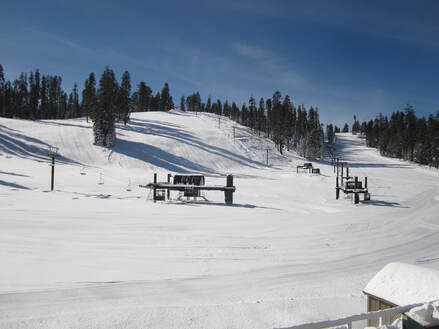
Badger Pass Ski Area will not open for the 2020-21 season
Due to ongoing concerns related to COVID-19, Badger Pass Ski Area will not open for the 2020-21 season. This includes both Nordic and downhill operations.
We are in the process of contacting season pass holders with the option of a season pass rollover or refund. Thank you for your continued interest in California’s original ski area, and we hope to see you next season! — sharing a COVID-19 Update at Badger Pass Ski Area.

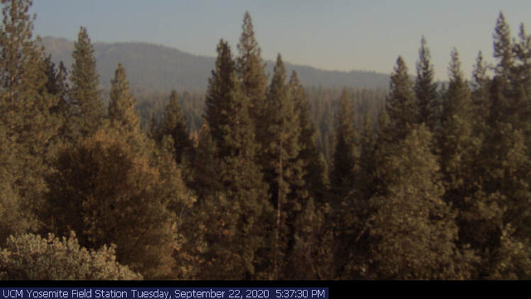
YOSEMITE-WAWONA ELEMENTARY CHARTER SCHOOL
Board of Directors Regular Meeting
Tuesday, September 22, 2020
5:30 P.M.
Wawona Elementary School
7925 Chilnualana Falls Road
Wawona, CA
ZOOM Meeting
CALL TO ORDER
ROLL CALL
MONTHLY ITEMS AND FINANCIAL REPORTS
HEARING OF PERSONS WISHING TO ADDRESS THE BOARD
The public may address the Board on any matter pertaining to the school that is not on the agenda. There will be no Board discussion and no action will be taken unless listed on a subsequent agenda. Speakers will be limited to 3 minutes.
ACTION ITEMS
APPROVAL OF LEARNING CONTRINUITY AND ATTENDANCE PLAN FOR 2020-21
Consideration and action on the approval of the Learning Continuity and Attendance plan as discussed at the regular Board meetings on August 8 and September 15.
BOARD MEMBER COMMENTS
FUTURE AGENDA ITEMS
Request that various items be placed on the next agenda for discussion and/or action.
NEXT BOARD MEETING
Unless otherwise announced, the next regular meeting of the Board of Directors will be scheduled for Tuesday, October 13, 2020, at 5:30 p.m. at the Wawona School.
ADJOURNMENT
Creek Fire Full Detail Map
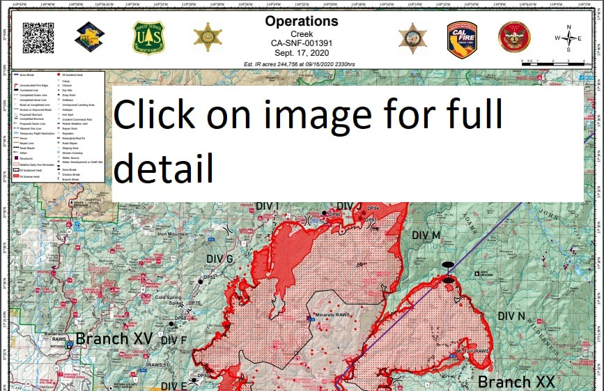
Creek Fire Briefing - September 17
Click to set custom HTML
Creek Fire Perimeter Map as of 7:00 AM, Sept. 17
Size: 244,756 Acres
Contained: 18%
Thursday, September 17ABC30 News - The Creek Fire is now the 10th largest wildfire in California's modern history after more than 244,000 acres have burned.
Clearer skies and breezy conditions will be factors the next few days for firefighters battling the wildfire.
Officials say the weather will likely increase fire activity both during the day and night. Firefighters are focused on strengthening and holding containment lines around communities and key areas.
More than 200 marines, and ten members of the Navy will arrive in Central California this Saturday and Sunday.
Creek Fire Briefing Video, September 16
Size: 228,025 Acres, Contained: 18%, Making Progress in the North, But Slow,
Pushing Fire North-East Towards National Barriers (High Elevation Granite)
Yosemite Hospitality Temporarily Closes All Operations at Curry Village Through Thursday, September 24 Due to Wildfire Smoke
Sierra Sun times
September 16, 2020 - Yosemite Hospitality has temporarily closed all operations at Curry Village through Thursday, September 24 in the interest of employee and visitor health due to the current and forecast AQI. The temporary closure includes all lodging, food and beverage, and retail services (food trucks, CV Grocery & Gift, Mountain Shop).
All reservations are being moved to Yosemite Valley Lodge. Any visitors with questions about their lodging reservations should contact Yosemite Hospitality Central Reservations at 888-413-8869.
Degnan's and the Village Store remain open in Yosemite Village. Basecamp Eatery and the Grocery & Gift Shop remain open at Yosemite Valley Lodge. The Ahwahnee Dining Room (takeout only), Sweet Shop, and Gift Shop remain open.
Services at Curry Village will resume again on Friday, September 25, conditions permitting.
Source: NPS
CreekFire Morning Update 9/16/20
220,025 Acres, 18% Containment
Madera County:
Estimated containment for the fire has increased to 18%. The weather conditions yesterday afternoon brought more of a southwest wind, which allowed for some clearing of the smoke conditions along the west side of the fire. Today’s weather conditions will feature lower humidity levels which may fall below 10% relative humidity, with very little recovery overnight. This dry air coupled with clearing smoke conditions may lead to increased fire activity this afternoon, especially along the northern fire perimeter. Wind conditions will increase Thursday afternoon into Friday in the higher elevations of the Sierra National Forest further supporting fire spread on the north and northeast flanks.
Road clearing operations continue along the 81 Road and Mammoth Pools Road. This will eventually provide safer access to the northern fire perimeter for the fire crews. Operations also continue to remove an estimated 1,500 cattle remaining in the fire area. Beekeepers are working on removing active beehives from along the fire lines, which will allow crews to work in those areas.
A major factor in containment progress along the perimeter are snag patches. These patches are areas of dead trees which have been burned but remain standing. These trees are a constant safety threat to fire crews and the greatest threats need to be felled. Residents returning to evacuated areas are advised to avoid these areas and to be aware of the danger of falling trees. Damage assessments are approximately 55% complete; the county will notify property owners directly as information becomes available.
The Madera County Sheriff’s office has again lifted evacuation orders, reducing the number of evacuated residents to approximately 11,000. As a result of the reduced evacuation orders, the Red Cross Temporary Evacuation Facility at the Mariposa Fairgrounds has been closed. Please visit the Sheriff’s website (QR code and complete web address below in yellow highlight) for current updates on evacuation orders and warnings.
Air operations are resuming missions slated for today. Please respect the Temporary Flight Restriction; keep drones away from the fire and firefighting operations. If you fly, we can’t! Don’t be the reason a firefighting air mission has to divert!
Creek Fire North Zone Briefing, September 16
Creek Fire Perimeter Map as of 7:00 AM, Sept. 16
Creek Fire 18% Contained
Outlook:
North Zone: Fire will progress primarily to the north and northeast towards Balloon Dome, Granite Creek, Bowler, Portuguese Viewpoint, Globe Rock, and Little Shuteye Peak. Fire will also continue to be active Central Camp, South Fork Bluffs and Whiskey Falls.
Remarks:
Acreage did not increase because crews were unable to collect IR perimeter data during the day. Indication of fire growth was observed through satellite Intel but fire department was unable to determine the exact amount of growth.
Weather Concerns:
North Zone: Smoke was heavy in the morning, but the slow clearing forecast began in the afternoon with some sun. Temperatures remain very warm Wednesday and Thursday with very low humidity and poor overnight recovery. RH minimums down to the single digits with almost no recovery Wednesday night. A break in the inversion is possible Wednesday and likely on Thursday as winds aloft increase from the southwest. Winds will also gradually increase with more sun and increased flow aloft. A cold front will move through Thursday night into Friday with gusty winds in the higher elevations near the Sierra Crest to 40 mph or more. Winds will remain gusty Friday as humidity increases with cooler conditions. Lighter winds and seasonable conditions are expected for the weekend with a return to smoky conditions likely.
InciWeb- Incident Information System
Creek Fire North Zone Briefing, September 15
Creek Fire: 220,025 Acres Burned With 16% Containment,
By ABC30.Com Staff
CAL FIRE officials say the Creek Fire grew to 220,025 acres overnight while containment remained at 16%.
In total, approximately 555 structures have been destroyed and 47 were damaged by the flames since the wildfire broke out. Damage assessment was 46% complete as of Tuesday morning.
Officials say their firefighting efforts are being hampered due to the thick smoke. It's keeping airplanes and helicopters grounded and unable to help by dropping water and fire retardant on the flames.
